In this California Highway article we examine the history of California State Route 222 between Ukiah and Talmage in Mendocino County.

California State Route 222 ("CA 222") is a two mile State Highway which connects from US Route 101/Redwood Highway in Ukiah east via Talmage Road to the community of Talmage. CA 222 notably isn't signed with reassurance shields but does include Post Mile paddles. CA 222 has a surprisingly long history which is rooted in serving Mendocino State Hospital.

Part 1; the history of California State Route 222 and Mendocino State Hospital
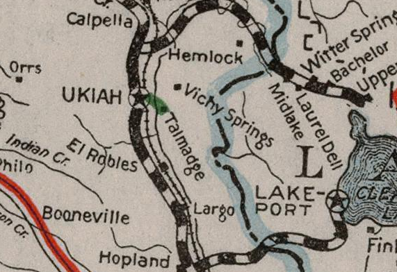
The origin of CA 222 traces back to 1925 when Legislative Route Number 70 ("LRN 70") between Ukiah and Mendocino State Hospital was adopted into the State Highway System. The original definition of LRN 70 was; "LRN 1 (future US 101) near Ukiah to the west line grounds of Mendocino State Hospital." LRN 70 according to CAhighways.org was stated to have originated from LRN 1 2,446 feet south of the Ukiah Town Limit in it's original definition along Talmage Road. LRN 70 can be first be seen on the 1926 Division of Highways State Map.

The full history of Mendocino State Hospital can be found on asylumprojects.org. Mendocino State Asylum was established in 1889 by the State Legislature. During October of 1890 contracts for the male ward of the Asylum and much of the facility in Talmage were set. During January of 1891 contracts for the female ward of the Asylum were set. Construction of Mendocino State Asylum began during April 1891 and was completed by December 1893. Mendocino State Asylum was renamed to "Mendocino Asylum" by the State Legislature during 1893, the original main building can be seen below.

The original Mendocino Asylum grounds can be seen below. The community of Talmage essentially grew with the expanding Mendocino Asylum.

Below is a 1935 Postcard of the Main Building of Mendocino State Hospital.

During 1897 Mendocino Asylum was renamed to "Mendocino State Hospital" as part of the amusingly unfriendly sounding "Insanity Law." By 1935 the population of the original Mendocino State Hospital facility would reach 2,600 patients. During 1952 the original Main Building of Mendocino State Hospital was razed as part of a series of projects to renovate the facility grounds. Mendocino State Hospital reached a peak patient population of approximately 3,000 by 1955. At it's peak Mendocino State Hospital employed 700 people.
Mendocino State Hospital was closed during 1972 as part of a State Government reorganization spurred by then Governor Ronald Reagan. Amusingly and somewhat ironically the State Government reorganization efforts during 1972 also saw the Department of Public Works merged with the Department of Aeronautics to form modern Caltrans. Mendocino State Hospital was purchased by the Dharma Realm Buddhist Association during 1974 and the City of Ten Thousand Buddhas was established during 1976. The City of Ten Thousand Buddhas incorporated much of the existing Mendocino State Hospital and expanded their facility largely during the 1980s.
The original alignment of LRN 70 can be seen on the 1935 Division of Highways Map of Mendocino County. The original alignment of US 101/LRN 1 ran through downtown Ukiah via State Street which meant LRN 70 was approximately 0.41 miles longer than CA 222 is today.

During the 1964 State Highway Renumbering LRN 70 was reassigned as CA 222. CA 222 initially retained the same alignment and definition of LRN 70. CA 222 can be seen for the first time on the 1964 Division of Highways State Map.


CA 222 was shortened to it's current length when US 101/Redwood Highway was moved to a bypass of Ukaih. The November/December 1964 California Highway & Public Works Guide ("CHWP") cites that 10.6 miles of freeway bypass realignment of US 101 in Ukiah was completed with it anticipated to be opened to traffic during Fall of 1965.

The US 101/Redwood Highway bypass is described as complete in the November/December 1965 CHPW.


During 1981 the definition of CA 222 was changed to; "Route 101 near Ukiah easterly to East Side Road in Talmadge." "Talmadge" is sometimes used as an alternative spelling for the community of Talmage. The route definition of CA 222 was changed to end in "Talmage" during 1990. Despite no longer accessing a State facility there has never been a documented push to relinquish CA 222. Likely CA 222 remains an active State Highway due to the bridge over the Russian River in addition to a somewhat large traffic count which approaches 10,000 vehicles a day.
Part 2; a drive on California State Route 222
Our drive on CA 222 begins on former US 101 northbound on State Street in Ukiah at the intersection with Talmage Road. From State Street northbound a shield directing traffic east to US 101 via Talmage Road. Note; the photos below were snipped from Google Street View.

Before US 101/Redwood Highway moved to it's bypass route it began on Talmage Road immediately east of State Street.

Former CA 222 on Talmage Road crosses a set of railroad tracks approaching Waugh Lane.

Before US 101/Redwood Highway was moved the route of Talmage Road and LRN 70 followed what is now Talmage Frontage Road west of the freeway and Cadwell Frontage Road east of it. Former Talmage Road/LRN 70 in the form of Talmage Frontage Road can be seen in the photo below to the left.

Modern CA 222 begins at the southbound ramp to US 101 at Post Mile MEN L0.412. The "L" suffix denotes a overlap Post Mile.


CA 222/Talmage Road eastbound crosses over US 101. From the freeway overpass former Talmage Road/LRN 70 in form of Caldwell Frontage Road can be seen on the left.


CA 222/Talmage Road crosses over the Russian River via the Ron Ledford Memorial Bridge at Post Mile MEN 0.98.


CA 222 can be seen on the Bridge Identification Post Mile at the Ron Ledford Memorial Bridge. The previous designation of as the "Russian River Bridge" can be seen painted on the structure itself. The current bridge name was enacted by the State Legislature during September of 2012 to honor Ron Ledford a deceased Ukiah Valley resident.


CA 222's east terminus if located at Post Mile MEN 2.153.
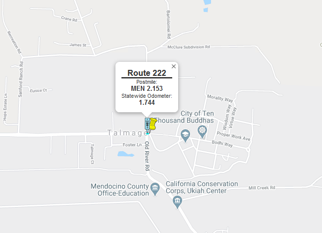
East of Old River Road the route ahead continues as Bodhi Way into the former grounds of Mendocino State Hospital. The large gate on Bodhi Way services as the entrance way to the City of Ten Thousands Buddhas.

Comments