
My journey was CA 1 was approximately 123 miles from the junction of CA 46 north of Harmony of San Luis Obispo County towards CA 156 in Castroville of Monterey County. While there is plenty of flat and straight segments of CA 1 between the two endpoints the route through Big Sur makes up for it with plenty of curves.

Part 1; the history of the Cabrillo Highway through Big Sur and the Monterey Peninsula
The backstory of the coastal route occupied by CA 1 in Big Sur is surprisingly old. A trail from Monterey southward to El Rancho Sur between the Little Sur and Big Sur River existed as early 1853. This trail was declared a public road by Monterey County in 1855. By 1870 the trail had been improved to a wagon road as far south as Bixby Creek. The 1873 California Geological Survey Map of Central California shows the primitive road south from Carmel to the Little Sur River.

By 1886 the trail south to the vicinity of Sycamore Canyon at W.B. Post's Ranch had been improved enough to allow wagon travel. The wagon route from Carmel south to Post's Ranch can be see on the 1896 Blum Map of Central California.

Today much of this old wagon road exists as Coast Road from the Bixby Creek Bridge south to Andrew Molera State Park. The 1935 Division of Highways Map of Monterey County shows in detail how far inland Coast Road is compared to modern CA 1.

In 1894 Dr. John Roberts traveled out of Monterey to Point Sur to respond to a wrecked ship by of the existing wagon road. The trip ultimately spurred Dr. Roberts to petition the state legislature to build a roadway between Carmel and San Simeon. The crux of the argument for a coastal roadway was that it help national defense during World War I. All the above is detailed on a historic plaque just south of the Big Creek Bridge at the Big Creek Vista located at Post Mile MON 27.325.

In 1919 the State Legislature approved $1,500,000 dollar bond to build Legislative Route 56 from Carmel south to San Simeon. LRN 56 as part of the 1919 Third State Highway Bond Act. Full details on the legislative history of LRN 56 can be found on CAhighways.org.
CAhighways.org on LRN 56
LRN 56 between Carmel and San Simeon first appears on the 1920 Division of Highways Map as an unbuilt highway.

In 1921 the Legislature extended LRN 56 south to Cambria which is reflected on the 1922 Division of Highways Map. The Division of Highways assumed control of the existing road between Cambria and San Simeon while a section of LRN 56 near Ragged Point north to the Monterey County line appear as under construction. Incidentally 1922 was the last time Tulare Lake appeared on a State Highway Map.

On the 1924 Division of Highways Map a section of LRN 56 south of Big Sur appears under construction.

The March 1926 California Highways and Public Works Guide cites that the Division of Highways assumed control of the existing highway from Carmel south to the Big Sur River. Statements like "Bugbear" (which apparently means; a cause of obsessive fear, irritation, or loathing) and "somewhat safer" are amusing to read in a modern context.


On the 1928 Division of Highways State Map work on LRN 56 north from Ragged Point continued into Monterey County approaching Gorda.

The December 1931 California Highways and Public Works Guide details the construction of the Garrapata Creek and Granite Creek Bridges. The Garrapata Creek Bridge is cited to have opened in November of 1931 and the Granite Creek Bridge was anticipated to open in early 1932.


In 1931 LRN 56 was extended south to San Luis Obispo which is reflective on the 1932 Division of Highways Map. A third construction segment south out of Carmel to Point Sur also appears on the 1932 State Highway Map.

The dedication ceremony for the opening the Bixby Creek Bridge was held on November 28, 1932 according to the December 1932 California Highways and Public Works Guide. The Bixby Creek Bridge to most is the signature structure of CA 1 within the Big Sur region and is a direct replacement of Coast Road.


In 1933 LRN 56 was extended south to LRN 2 (US 101) near Las Cruces and north to Ferndale to LRN 1 (also US 101). Subsequently LRN 56 was routed through the Monterey Peninsula on what had been a previously locally maintained highway. LRN 56 appears completed in Big Sur on the 1934 Division of Highways Map aside from a segment near Lopez Point.

In the August 1934 California Highways and Public Works Guide the Sign State Routes were announced. CA 1 was applied to LRN 56 from Las Cruces northward towards Fortuna

The October 1934 California Highways and Public Works Guide cites that the very first Sign State Route Shield was installed as part of CA 1 in Carmel. The Sign Route shield was installed on September 10, 1934, at the junction of the Carmel, Pacific Grove, and Monterey Highways. Note; the article stub also cites that early Sign Route shields were to be installed by the Auto Clubs and not the Division of Highways by way of a cooperative agreement.


Within Carmel the original alignment of CA 1/LRN 56 was along the same corridor the modern highway takes north near Hatton Canyon from Carmel Valley Road (County Route G16) north to Carpenter Street. From Carpenter Street the initial route of CA 1/LRN 56 continued north atop the same right-of-way the modern freeway uses to Munras Avenue. CA 1/LRN 56 north continued into downtown Monterey onto Abrego Street. Within downtown Monterey the original route of CA 1/LRN 56 followed Abrego Street and turned on Del Monte Avenue. CA 1/LRN 56 originally continued north on Del Monte Avenue through Seaside onward towards Marina. Within Marina CA 1/LRN 56 originally followed Del Monte Boulevard. North of Marina CA 1/LRN 56 followed Lapis Road towards Neponset and Salinas River. Originally CA 1 crossed the 1914 Neponset Truss Bridge next to the Southern Pacific Monterey Branch. Originally CA 1/LRN 56 northbound entered Castroville via Preston Road where it turned left at Merritt Street.
The opening of the Malpaso Creek Bridge is discussed in the September 1935 California Highways and Public Works Guide.

On June 27th, 1937, CA 1 opened entirely through Big Sur and as the Carmel-San Simeon Highway. The surface of CA 1 in Big Sur when it opened was oiled earth aside from the segment north of the community of Big Sur. This is all reflective on the 1936-37 State Highway Map.

The opening of the Carmel-San Simeon Highway through Big Sur is the cover story of the July 1937 California Highway and Public Works Guide.


A secondary article in the July 1937 CHPW Guide discusses the twenty-nine bridges of the Carmel-San Simeon Highway.


During World War II the route of CA 1 was renamed the Roosevelt Highway in honor of Franklin Delano Roosevelt. CA 1 in Big Sur was initially opened as a seasonal highway which was closed during the winters due to heavy rainfall and landslides. The winter of 1941 in Big Sur was so heavy with 160 inches of rain that the state considered abandoning much of CA 1 between Carmel and San Simeon. The history of closures of CA 1 in Big Sur due to rain and landslides has been such a common occurrence that it has affected the highway ever since it opened fully in 1937.
CA 1/LRN 56 appears shifted onto Fremont Street from Munras Avenue in downtown Monterey through Seaside on the 1942 Division of Highways Map. The alignment of CA 1/LRN 56 onto Fremont Street eliminated a large bottleneck point in downtown Monterey that would have been an issue on the original highway.

The September/October 1944 California Highways and Public Works Guide discusses the improved route of CA 1/LRN 56 from the City Limit of Monterey to Castroville. Part of the new alignment of CA 1/LRN 56 included a new bridge over the Salinas River which opened in 1943 and replaced the 1914 Neponset Bridge. Numerous four-lane sections of CA 1/LRN 56 were opened which appear to be spurred by military interests out of Fort Ord which would have been a priority during World War II.


The improvements described above also had a dramatic impact on highway flow via LRN 22 from Castroville to Prunedale which was intended to reach US 101/LRN 2 more efficiently. The effects on traffic in Castroville can be viewed on the article below:
Historic Highway Alignments in Castroville
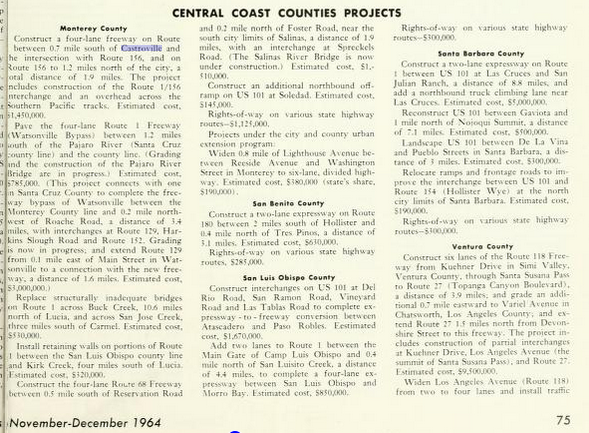
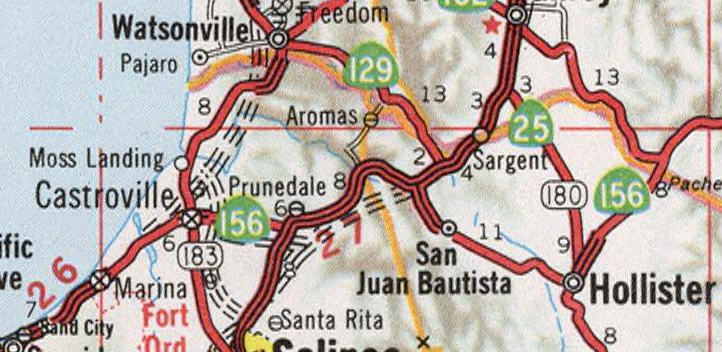
During the 1964 State Highway Renumbering all Legislative Routes were dropped in favor of field signage. CA 1 and CA 156 essentially remained the same in Castroville but LRN 118 was reassigned as CA 183. On November/December 1964 California Highways and Public Works guide a new freeway alignment of CA 1 in Castroville is discussed which included a new junction with CA 156. This new alignment included CA 156 being routed over a new overpass of the Southern Pacific Railroad in Castroville.
Within Monterey the result of the 1964 State Highway Renumbering was that CA 68 was extended on multiplex over CA 1 onto what had been LRN 262 towards Asilomar State Beach. The multiplex of CA 68 on to CA 1 can be seen on the 1964 Division of Highways State Map.

The November/December 1965 California Highways and Public Works Guide cites that a new 6.7 mile freeway alignment of CA 1 from the southern City Limit of Monterey and Fort Ord as budgeted for the 1967-68 fiscal year. The new freeway alignment of CA 1 included a freeway interchange with CA 68 eastbound towards Salinas.

On the 1967 Division of Highways State Map the new route of CA 1 and CA 156 in Castroville appear as completed. Note; CA 156 is shown having a planned freeway route east to Prunedale which was never built.
The 1967 Division of Highways State Map also displays the planned freeway alignment of CA 1 between the south City Limit of Monterey and Fort Ord. It seems that the freeway alignment bypass of Monterey was intended to begin near Carmel Valley Road.

The 1969 Division of Highways State Map shows the interchange of CA 1/CA 68 complete which implies that the freeway through Monterey had opened. Unfortunately, the California Highways and Public Works Guides had ended a couple years prior so there is no construction documentation to link for exact dates of the project. The new freeway alignment of CA 1 through the Monterey Peninsula bisected the former surface route on Fremont Street. .

The planned origin point of the CA 1 Freeway at Carmel Valley Road disappears on the 1970 Division of Highways Map which implies it had been cancelled.

At some point between 1970 and 1975 CA 1 through Cambria was moved off of Main Street onto the modern bypass route. The new alignment of CA 1 through Cambria was built in conjunction with CA 46 moving off of Santa Rosa Creek Road. The new alignment of CA 1 and CA 46 near Cambria can be seen on the 1975 Caltrans State Highway Map.

At some point between 1979 and 1981 CA 1 was relocated west of Castroville onto a bypass (the bridge ID of CA 156 west under CA 1 north is blacked out in field). The realignment of CA 1 extended CA 156 west onto the Castroville Freeway grade to it's present west terminus and shifted CA 183 through downtown via Merritt Street. The new alignment of CA 1 and CA 156 can be seen on the 1981 Caltrans State Highway Map.

In 2005 CA 1 between Las Cruces north to San Francisco was designated the Cabrillo Highway by State Streets and Highway Code Section 635. The Cabrillo Highway is reference to Spanish Explorer Juan Rodriguez Cabrillo. Cabrillo was the first European Explorer of California who journeyed the future State in 1542-1543. Cabrillo ultimately died of an infection brought on by an injury sustained while attempting to rescue some of his men from attacking members of Tongva Tribe.
Part 2; a drive on CA 1 from CA 46 north through Big Sur and the Monterey Peninsula to CA 156
My approach to CA 1 was from CA 46 westbound in San Luis Obispo County near the village of Harmony. I made a right hand turn onto CA 1 northbound from the west terminus of CA 46.


CA 1 north of CA 46 is signed as 106 miles from the City of Monterey. Hearst Castle is noted to be 12 miles to the north.

CA 1 north of CA 46 is signed with scenic placards, this one in the photo below appears to be new.

Trucks are shown not be advised on CA 1 north of San Simeon.

CA 1 north has a large guide sign which is intended to display if access through Big Sur is available. On CA 1 northbound Ragged Point is shown to be 26 miles away, Gorda 38 miles away, Big Sur 75 miles away, and Carmel 102 miles away.

Interestingly there is what appears to be a permanent construction sign for CA 1 northbound. This is likely due to the nature of Big Sur being a muddy region that is prone to landslides.

CA 1 north enters Cambria and intersects it's former alignment at Main Street at Post Mile SLO 48.26.


Cambria was the site of a cinnabar discovery in 1862. Through much of the 1870s numerous Mercury mining claim were plotted in the Santa Lucia Mountains which morphed Cambria into a boom town. Numerous local landmarks to CA 1 like Nitt Witt Ridge of Hillcrest Drive can be found in Cambria. Nitt Witt Ridge began in 1928 when Art Beal bought a hillside property and spent the next five decades building it into a living art display.


Random AMC Gremlin sighting on Burton Drive.


A look south on former CA 1/Main Street from the Bridge Street intersection.

Some asssorted photos from the annual Cambria Pines Christmas Light Show.


Returning to modern CA 1 northbound the highway passes through Cambria and intersects the opposite end of Main Street by way of Windsor Boulevard at Post Mile SLO 50.668.


North of Cambria CA 1 passes by Leffingwell Landing State Park, Monterey is signed as 100 miles away.


CA 1 north passes through San Simeon State Park near Van Gordon Creek.


CA 1 north of San Simeon State Park enters the modern part of San Simeon.


CA 1 north passes by Old Stage Coach Road and begins to approach San Simeon Bay. San Simeon Point can be seen off in the distance.


San Simeon Bay has numerous vista points along CA 1 northbound. At Post Mile SLO 57.815 CA 1 intersects Hearst Castle Road and San Luis Obispo (SLO) San Simeon Road.


The original alignment of CA 1 was through San Simeon on SLO-San Simeon Road. CA 1 was moved off of SLO-San Simeon Road to the modern alignment running past Hearst Castle Road between 1943 and 1960 according to topographical maps on historicaerials.com. It is likely that SLO-San Simeon Road was only likely a temporary alignment of CA 1 and probably was replaced long before 1943.
San Simeon was founded in Alta California 1836 on San Simeon Point as a sub-mission of Mission San Miguel Arcangel. Over the following decades San Simeon grew as a whaling town and had a significant cattle grazing industry. Part of the lands around San Simeon were sold to George Hearst in 1865. Hearst in turn built a new wharf in 1878 which replaced the heavily eroded former wharf. The 1878 Hearst Wharf is where the present community of San Simeon is located.
San Simeon still has several historic structures dating back to the 1878 Hearst Wharf. Sebastian's Store was part of the original San Simeon community but the structure was moved to the present site in 1878.


San Simeon today is mostly known for Hearst Castle which was built for Media Tycoon William Randolph Hearst the son of George Hearst. Hearst Castle sits high above San Simeon to the east in the Santa Lucia Range.

Hearst Castle was constructed in segments from 1919 to 1947 for newspaper magnate William Randolph Hurst. Hearst and the castle of the same name were largely the inspiration for the movie Citizen Kane.


As a personal aside I visited CA 1 through Big Sur along with Hearst Castle back in 1993. My Mom used to rave about going to back to Big Sur and even more so Hearst Castle but never got around it before she got sick. Last year at a family gathering we spread her ashes on the pier at San Simeon Bay where Hearst Castle could be seen high above.


North of San Simeon CA 1 traffic is advised that trucks are not recommended over the next 88 miles.

From San Simeon CA 1 north is shown as 90 miles form Carmel and 94 miles from Monterey. Ragged Point is shown to be 16 miles to the north.


CA 1 northbound intersects the Elephant Seal Vista at Post Mile SLO 62.466.


Approaching the Piedra Blancas Lighthouse is where CA 1 starts to follow the terrain a little more closely. At Post Mile SLO 63.774 CA 1 northbound intersects the access road to Piedra Blancas Lighthouse. The Piedra Blancas Light House was constructed in 1875 but several of the floors were removed due to earthquake damage after an earthquake in 1948.


The Piedra Blancas Lighthouse is the starting point for a recent relocation of project of CA 1 inland. The coastline north of the light house has been gradually eroding into the ocean for some time and the water lapping in can be pretty bad when the surf is high. The new roadway is located about 10 feet above the old one and has several new bridges over creek beds which flooded easily.


Back in April 2017 I viewed the relocation project of CA 1 north of Piedra Blancas Lighthouse.


Approaching Point Sierra Nevada the landscape really starts to open up and on a clear day the Big Sur region and the sheer cliffs really are apparent in the distance looking northbound on CA 1. At Post Mile SLO 71.357 CA 1 northbound crosses San Carpoforo Creek. San Carpoforo Creek is generally considered to be the southern boundary of Big Sur as the coastal mountains in the Santa Lucia Range tend to rise out of the Pacific much more abruptly.


Of note; San Carpoforo Creek was first observed by Europeans during the Spanish Portola Expedition on September 13, 1769. The Portola Expedition found the terrain through Big Sur northward to be impassable and turned east up San Carpoforo Creek through San Carpoforo Canyon. During the later De Anza Expeditions the Spanish knew to avoid the Santa Lucia Mountains and stayed on a path towards Salinas Valley by way of what is now San Luis Obispo.
North of San Carpoforo Creek CA 1becomes a very twisty road which can be difficult to drive on as it hugs the mountains overlooking the coast ascending up to Los Padres National Forest boundary at Ragged Point located at Post Mile SLO 72.926.


Ragged Point is a rock formation sticking out into the ocean with a resort of the same name located on top of it. The Ragged Point resort is one of few places in Big Sur that gas can be obtained.

CA 1 northbound ascends on cliffs generally 400 feet above sea level to the Monterey County Line.


The Monterey/San Luis Obispo County Line sign assembly is kind of nice looking up close with the CA 1 reassurance shield.


CA 1 continues north to the Salmon Creek Ranger Station at approximately Post Mile MON 2.361.


The Salmon Creek Ranger Station was the location of the closure gate for the Mud Creek Slide in 2017.

From the Salmon Creek Ranger Station Gorda is listed as 8 miles north on CA 1 and the Monterey Peninsula is shown to be 76 miles away.

CA 1 northbound continues to snake through the terrain of the Santa Lucia Mountains and eventually climbs to a pullout that overlooks the Mud Creek Slide.


CA 1 northbound passes over the Mud Creek Slide at Post Mile MON 9.015. The new roadway over the Mud Creek Slide is surrounded by Jersey Barriers on both sides to prevent traffic from stopping on the hazardous terrain. The Mud Creek Slide occurred in May of 2017 and took out a large section of CA 1. The Mud Creek Slide didn't reopen until July 2018. Coupled with Paul's Slide to the north access to the community of Gorda was cut-off aside from the Nacimiento-Fergusson Road.


Below is a stock photo of the Mud Creek Slide after it occurred in 2017.

At Postmile 10.172 CA 1 enters the community of Gorda. Gorda is one of the few places where gas is available on CA 1 in Big Sur, the community has roots dating back to 1878.


Pacific Valley is signed as being 5 miles north of Gorda on CA 1 and the Monterey Peninsula is signed as 67 miles away.

At Postmile MON 11.712 CA 1 north crosses Willow Creek which as a National Forest Campground.


CA 1 northbound passes through the community of Plaskett which mostly houses National Forest Service workers and enters Pacific Valley at approximately Post Mile MON 15.00.


From Pacific Valley the community of Lucia is signed as 7 miles to the north on CA 1 and the Monterey Peninsula is shown to be 61 miles away.


At the Mill Creek Bridge the grade of the Nacimiento-Fergusson Road can be seen from CA 1 north.


CA 1 northbound intersects the Nacimiento-Fergusson Road at approximately Post Mile MON 18.901.


The Nacimiento-Fergusson Road is the only roadway in Big Sur which crosses east over the Santa Lucia Range to Signed County Route G14. While the Nacimiento-Fergusson Road is paved it is largely one-lane, has grades in excess of 10%, and often has military closures from Fort Hunter Liggett.


Back in 2017 I visited CA 1 in Big Sur when it was isolated by the Mud Creek Slide and Paul's Slide via the Nacimiento-Fergusson Road. This was my favorite picture of the empty portion of CA 1 which could be seen from the Nacimiento-Fergusson Road.

The first seven miles of the Nacimiento-Fergusson Road eastward climbs a single lane roadway that has an average grade of 14%. While the Nacimiento-Fergusson Road is paved all the way east to Fort Hunter Liggett it definitely isn't for the faint of heart. In many ways the Nacimiento-Fergusson Road exceeds CA 1 in terms of steepness.


As the Nacimiento-Fergusson Road crests the Santa Lucia Range it crosses the Coast Ridge Road. The Coast Ridge Road by the early 20th Century was a primitive foot path between Post's Ranch south to Plaskett by way of Cone Peak. The Coast Ridge Road south (South Coast Ridge Road) of the Nacimiento-Fergusson Road is part of Forest Road 20S05. The Coast Ridge Road (Central Coast Ridge Road) north of the Nacimiento-Fergusson Road is part of Forest Road 22S05 towards Cone Peak. North of Cone Peak the Coast Ridge Road is known as the North Coast Ridge Trail and emerges to CA 1 at Posts Creek.


CA 1 north of the Nacimiento-Fergusson Road crosses over Kirk Creek and passes by the Kirk Creek Campgound.

At Post Mile MON 20.94 CA 1 approaches Limekiln Creek and Limekiln State Park.


Limekiln State Park was founded in 1994 largely due to public outcry over the plans a private landowner to log Coastal Redwoods on West Fork Limekiln Creek. Limekiln State Park contains the ruins of the Rockland Lime Company kilns which harvested limestone from 1887 through 1890 on West Fork Limekiln Creek. The Rockland Lime Company kilns are located on what is now the Limekiln Trail.


The Limekiln Falls Trail is heavily damaged from the winter of 2017 but can be traversed carefully up East Fork Limekiln Creek to Limekiln Falls.

Limekiln Beach has some fantastic views of the Limekiln Creek Bridge and the ocean.


North of Limekiln State Park CA 1 enters the Pickens Curve Tunnel which recently opened in 2014.


CA 1 northbound crosses over Paul's Slide and passes through the community of Lucia at Post Mile MON 23.023. Paul's Slide was the location of one of the larger slides in the winter of 2017 but was functionally reopened relatively quickly to allow the community of Lucia access to the Nacimiento-Fergusson Road.


Below shows how beat up CA 1 south through Paul's Slide was during December of 2017.


Big Sur is signed 24 miles north of Lucia on CA 1, Monterey is signed as 55 miles away.


CA 1 north continues to the Big Creek Bridge Vista at Post Mile MON 27.235. The Big Creek Bridge is a 588.9 foot long arch concrete bridge which was completed in 1938 (the year after CA 1 between Carmel-San Simeon opened to traffic). The historical plaque observed in Part 1 is located at the Big Creek Bridge vista.


CA 1 northbound crosses the Big Creek Bridge. At Post Mile MON 32.733 CA 1 north enters Slates Hot Springs which is the location of the Esalen Institute.


CA 1 continues north to Julia Pfeiffer Burns State Park at Post Mile MON 36.309.


North of Julia Pfeiffer Burns State Park CA 1 next reaches vista at Partington Point at Post Mile MON 37.711.


CA 1 continues north through windy terrain which ascends to above 400 feet above sea level. At Post Mile MON 40.875 CA 1 north passes by the Coast Galley and Cafe.


Big Sur is signed as 6 miles north of the Coast Gallery on CA 1 whereas the Monterey Peninsula is signed as 37 miles away.


CA 1 north proceeds into Castro Canyon and passes by Deetjen's Big Sur Inn at Post Mile MON 43.191.


At Post Mile MON 43.559 CA 1 north passes by Henry Miller Library.

CA 1 north enters Posts and passes by the north segment of the Coast Ridge Road at Post Mile MON 44.544. CA 1 north in Posts passes by the Ventana Campground and a gas station at Loma Vista Big Sur Bakery & Restaurant.


CA 1 north crosses over the 2017 Pfeiffer Canyon Bridge at Post Mile MON 45.564.


In February of 2017 a mudslide damaged a support column on the bridge over Pfeiffer Canyon which led to the structure being condemned. The condemned bridge over Pfeiffer Canyon isolated the community of Posts which required a hike along Posts Creek to get to the open portion of CA 1. The stock photo below shows the damaged Pfeiffer Canyon Bridge in the process of demolition.

Back in September 2017 I visited the Pfeiffer Canyon Bridge rebuild project a couple weeks prior to it opening. At the time there wasn't much to see as traffic on CA 1 south was turned around at Pfeiffer Big Sur State Park.


The 2017 Pfeiffer Canyon Bridge opened on October 13th and cost $24,000,000 dollars to construct. I visited the 2017 Pfeiffer Canyon Bridge on October 19th when the road surface wasn't even fully finished. The photo below is the 2017 Pfeiffer Canyon Bridge from CA 1 southbound.

There was a handy construction pull-off on the south side of the 2017 Pfeiffer Canyon Bridge which allowed me to get a good look at the structure.


The lanes on the 2017 Pfeiffer Canyon Bridge are 12 feet wide and have 5 foot wide shoulders. The wide width of the 2017 Pfeiffer Canyon Bridge is something of an oddity on CA 1 in Big Sur as the older arch concrete structures are classified as functionally obsolete due to being too narrow. The date stamp on the 2017 Pfeiffer Canyon Bridge is a nice retro touch on a somewhat bland looking modern design.

The previous Pfeiffer Canyon Bridge was constructed by 1968 and was a concrete box girder design. The 1968 Pfeiffer Canyon Bridge replaced a wooden structure which likely originally to LRN 56 and CA 1. More on the 1968 Pfeiffer Canyon Bridge and a 1974 assessment can be found on the blog site below.
BigSurKate Blog on 1968 Pfeiffer Canyon Bridge
CA 1 northbound enters Pfeiffer Big State Park and crosses over Big Sur River. At Post Mile MON 46.808 CA 1 northbound passes by the main entrance to Pfeiffer Big Sur State Park..


Pfeiffer Big Sur State Park is located largely along the Big Sur River. The Big Sur River is 16 miles long and begins at a the confluence of the North Fork and South Fork Big Sur Rivers. The Big Sur River empties into the Pacific Ocean to the north at Andrew Molera State Park.


Pfeiffer Big Sur State Park has a grove of Coastal Redwood trees. Pfeiffer Big Sur State Park is named after John Pfeiffer who owned a cabin on the land the State Park is now located. A Los Angeles Real Estate investor made Pfeiffer an offer for his property in 1930 to develop a subdivision. Pfeiffer's response was to sell his tract of land to State of California instead in 1933 so it could be added to the State Park System.

I found the Buzzard's Roost Trail to be particularly noteworthy during one of my hiking trips to Pfeiffer Big Sur State Park. The Buzzard's Roost Trail follows the Big Sur River under CA 1 before it reaches the bottom of Pfeiffer Ridge.


Most of the Big Sur Region and Santa Lucia Range consists of soft dirt surfaces. The terrain lends itself to mudslides which are just as common within the State Parks as CA 1. The grade on the Buzzard's Roost Trail is steep, narrow, and has numerous long drops. As the Buzzards Roost Trail ascends the overgrowth clears to provide a clear view of Sycamore Canyon.


At the top of Pfeiffer Ridge the treeline opens up and the Pacific Ocean can be seen over Pfeifer Ridge Road.

The Buzzard's Roost is actually at an radio tower. The view is wide and has a sweeping view of Sycamore Canyon.


At Post Mile MON 48.661 CA 1 northbound passes through the community of Big Sur.


At Post Mile MON 51.171 CA 1 north reaches the entrance to Andrew Molera State Park and the southern terminus of Coast Road.

From Andrew Molera State Park CA 1 north is signed as 26 miles from the Monterey Peninsula.


CA 1 north passes the entrance to Point Sur State Historic Park at Post Mile MON 54.071.

Point Sur rises 361 feet above the Pacific Ocean and is the location of the Point Sur Lighthouse. The Point Sur Lighthouse dates back to 1889 and has a focal point of 270 feet above the waters of the Pacific.


CA 1 continues north over the Little Sur River at Post Mile MON 56.124.


CA 1 north ascends from the Little Sur River to Hurricane Point.


Hurricane Point overlooks Bixby Creek to the north and Point Sur to the south.


CA 1 north descends from Hurricane Point and crosses the Bixby Creek Bridge at Post Mile MON 59.412.


As noted above the Bixby Creek Bridge opened in 1932 and generally considered to be the signature span on CA 1 in Big Sur. The Bixby Creek Bridge has a 260 foot clearance above Bixby Creek. The Bixby Creek Bridge includes a historical plaque at the vista point.


The north terminus of Coast Road is located at the north abutment of the Bixby Creek Bridge. The contrast of the poorly graded Coast Road to the Bixby Creek Bridge offers a good perspective on how haggard the old highway from Carmel to Post's Ranch really was.

The best views of the Bixby Creek Bridge in my opinion are from Coast Road.


CA 1 north crosses the Rocky Creek Bridge at Post Mile MON 60.125.


The Rocky Creek Bridge was completed in 1932 and features similar terrain to the Bixby Creek Bridge.


At Post Mile MON 61.517 CA 1 northbound passes by Palo Colorado Road.


At Post Mile MON 61.922 CA 1 northbound passes by the driveway for the Rocky Point Restaurant.

The view on CA 1 south from the Rocky Point Restaurant towards Hurricane Point is quite pleasant.

CA 1 north at Post Mile MON 63.009 crosses the Garrapata Creek Bridge and enters Garrapata State Beach.


The Garrapata Creek Bridge was completed in 1931.

CA 1 north continues to the Granite Canyon Bridge at Post Mile MON 64.384.


The Granite Canyon Bridge was completed in 1932.

CA 1 continues northward and passes over the Malpaso Creek Bridge at Post Mile MON 67.892.


The Malpaso Creek Bridge was completed surprisingly late as the historic plaque displays a build year of 1935.

CA 1 north enters Carmel Highlands. At Post Mile MON 69.035 CA 1 north crosses over the 1933 Wildcat Creek Bridge.


CA 1 north continues through Carmel Highlands and passes by the main entrance of Point Lobos State reserve at Post Mile MON 70.371.


Point Lobos is a peninsula located on the south end of Carmel Bay. Point Lobos generally is considered to be one of the top tier State Parks in California due to having huge views of; the Monterey Peninsula to the North, as far as Point Sur to the south, and animal rich waters of the Pacific Ocean. Point Lobos has been under some sort of protective status back to 1933 when it was in private hands. Point Lobos tends to be the busiest State Park in Big Sur due to the close proximity to Monterey and Carmel. The Cypress Grove Trail which is on the actual Point Lobos overlooks the Monterey Peninsula over Carmel Bay.


From Point Lobos CA 1 north enters Carmel River State Beach.

Carmel River State Beach is located on Carmel Bay between the Monterey Peninsula and Point Lobos.

CA 1 northbound crosses the Carmel River at Post Mile MON 72.35 and enters Carmel. The Carmel River marks the commonly accepted northern boundary of the Big Sur region.

At Post Mile MON 72.619 CA 1 north passes Rio Road which is signed as access to Carmel (or...Carmel-By-the-Sea if you really prefer).


The area that is now Carmel was settled in Spanish Las Californias when Mission San Carlos Borromeo de Carmelo ("Mission Carmel") was relocated from Monterey in August of 1771. Mission Carmel was relocated due to Juniper Serra petitioning to make the move due to the ease of farming at the mouth of the Carmel River. Mission Carmel remained Serra's headquarters until his death in 1784.
When Alta California became part of Mexico the Catholic Missions were secularized which led to the lands held by churches loyal to be Spain being granted as Ranchos. John Martin acquired much of the land surrounding Mission Carmel in 1833 which was known as Rancho Las Manzanitas. During the American period beginning in 1848 Rancho Las Manzanitas changed hands numerous times and eventually was subdivided in 1888. The Carmel Post Office opened in 1889 but the area came to be known as "Carmel-By-the-Sea" in the early 20th Century due to it being referred to as such in a post card. Carmel officially incorporated in 1916, in modern times the community is mostly known for being the City that elected Clint Eastwood as mayor (which occurred in 1986).
CA 1 expands to a four lanes north of Rio Road. At Post MON 72.912 CA 1 north intersects County Route G16/Carmel Valley Road. CA 1 at Carmel Valley Road is probably the location where the first Sign State Route shield was placed in 1934.


At Post Mile MON 73.804 CA 1 north intersects Ocean Avenue which accesses downtown Carmel.


CA 1 expands to a freeway at Post Mile MON 74.552 north of Carpenter Street. At Exit 399A CA 1 north accesses CA 68 west towards 17 Mile Drive, Pebble Beach, and Asilomar State Beach.


CA 1 north picks up CA 68 east at Exit 399A and enters the City of Monterey. CA 1 Exit 399B accesses former CA 1 on Murnas Avenue which directs traffic towards Fisherman's Wharf, the Presidio Chapel, and Monterey State Historic Park. Murnas Avenue is noted to be part of CA 1 Business.


Fisherman's Wharf and the Customs House are located just off of former CA 1 north of Del Monte Avenue near Lighthouse Avenue. The Spanish discovered Monterey Bay in 1602 during the maritime expedition of Sebastian Vizanino, Monterey is the second oldest City California only to San Diego. The Presidio of Monterey and Mission San Carlos Borromeo were established in 1770. By 1777 Monterey became the capital of Spanish Las Californias and would remain the Capital of Alta California when it was formed in 1804. Monterey was the Capital of Mexican Alta California from 1822 to 1846 when it was ceded to American hands.The Customs House is located at Fisherman's Wharf and was the main entry point to the City of Monterey when it was completed in 1827.


Fisherman's Wharf was built in 1870 by the Pacific Coast Steamship Company for the unloading of passenger goods. Fisherman's Wharf was taken over by the City of Monterey in 1913 and was a hub of the sardine trade. Fisherman's Wharf today is largely a tourist attraction that caters visitors to Monterey.


CA 1 north/CA 68 Exit 401A accesses Fremont Street and Aguajito Road. The CA 1 north/CA 68 east freeway bisects the later surface alignment of CA 1 on Fremont Street. Exit 401A is signed oddly from CA 1 north/CA 68 east as access to the Monterey Bay Aquarium.


The Monterey Bay Aquarium is located on Cannery Row. Cannery Row was part of the original 1901 alignment of 17 Mile Drive. Cannery Row began hosting sardine canning companies starting in 1902 and was served by the Southern Pacific Monterey Branch Railroad. By the 1970s Cannery Row was in decline as the sardine industry essentially dried up. In 1984 the Monterey Bay Aquarium opened by the City of Montery in what was the Portola Brand Sardine facility. Monterey Bay Aquarium spurred reinterest in Cannery Row as a tourist district which led to much of it being redeveloped.


CA 1 north splits from CA 68 east at Exit 401B. Exit 401B accesses former CA 1 on North Fremont Street.


North Fremont Street is signed as CA 1 Business. The CA 1 Business signage on North Fremont Street appears to be locally made.

CA 1 north Exit 402A accesses Casa Verde Way.


CA 1 north Exit 402B accesses former CA 1 on Del Monte Avenue.


Del Monte Avenue at the northern City Limit of Monterey has some abandoned rails of the Monterey Branch Railroad. The abandoned rails of the Monterey Branch Railroad can be found on the coastal side of Del Monte Avenue next to the Monterey Coastal Bay Coastal Trail.


The Monterey Branch was a 18.5 mile standard gauge railroad between Pebble Beach northeast to the Union Pacific Switch in Castroville. The Monterey Branch was partially built upon the narrow gauge Monterey & Salinas Valley Railroad in 1874. The Monterey & Salinas Valley Railroad went bankrupt in 1879 and was purchased by the Southern Pacific Railroad. The Southern Pacific converted their new Monterey Branch to standard gauge in and rerouted it from a terminus in Salinas to Castroville by 1880. The Monterey Branch was noted for carrying passenger traffic between San Francisco and Pebble Beach in addition to freight traffic from Cannery Row. The Monterey Branch Railroad can be seen on George Blum Regional Map of California ending at the second Hotel Del Monte in 1896.

The Monterey Branch can be seen terminating at Pebble Beach on the 1935 California Division of Highways Map of Monterey County.

The Monterey Branch operated passenger lines until 1971. According to abandonedrails passenger service on the Monterey Branch was shuttered because it would only be a service line of 125 miles. A distance of 125 miles was 25 miles shy of the minimum Amtrak was required to operate. Freight operations on the Monterey Branch shuttered in the 1990s with the last train being run by the Transportation Agency of Monterey County in 1999. Also in 1999 the Union Pacific Railroad removed the switch for the Monterey Branch in Castroville. The Monterey Branch was purchased by the Transportation Agency of Monterey County in 2003.
In recent times much of the right-of-way of the Monterey Branch in the City of Monterey was converted to part of the Monterey Bay Coastal Trail. At present moment the Transportation Agency of Monterey County plans to convert the remaining line to light rail use with stations in; Monterey, Sand City, Marina and eventually Castroville.
Former CA 1 on Del Monte Avenue and the Monterey Branch Railroad served the third Hotel Del Monte which was completed in 1927. In 1947 the U.S. Navy purchased the third Hotel Del Monte. The Naval Post Graduate School was moved to Monterey in 1951. The original Hotel Del Monte opened on June 3rd, 1880 and was constructed by the Pacific Improvement Company. The Pacific Improvement Company was a property division of the Southern Pacific Railroad which operated the Del Monte Resort.

CA 1 north enters Seaside and accesses CA 218 at Exit 403.


Exit 403 on CA 1 south is particularly nice to view since it overlooks the Fort Ord Dunes and the Monterey is Peninsula.

CA 1 north passes through Sand City. At Exit 404 CA 1 north acceses two former alignments of CA 1 on Del Monte Boulevard and Fremont Street.


CA 1 north reenters Seaside and at Exit 406 accesses Lightfighter Drive. The Ord Military Community and Cal-State University Monterey Bay are shown to be accessible from Lightfighter Drive.


CA 1 north enters Marina and accesses Imjin Parkway at Exit 408.


Some of the old barracks buildings from Fort Ord are located north of Imjin Parkway by way of 2nd Avenue in Marina. Fort Ord was originally an Army range known as Camp Ord which was designated in 1917 during World War I. In 1940 Camp Ord was expanded, in 1941 it was redesignated as Fort Ord. Parts of Fort Ord were sold in 1957 to build Laguna Seca Raceway. In 1991 the decision to close Fort Ord as part of the Base Realignment and Closure Act was signed into law, the base was closed during 1994. Much of the infrastructure annexes of Fort Ord were added to Marina and Cal-State Monterey Bay. Much of former range areas of Fort Ord was added to Fort Ord National Monument in 2012.

CA 1 north Exit 409 accesses CA 1 Business on Del Monte Boulevard.


CA 1 north Exit 410 accesses County Route G17 on Reservation Road.

CA 1 north Exit 412 accesses former CA 1 on Del Monte Boulevard near Neponset and the Salinas River.


CA 1 north crosses the Salinas River in view of former CA 1 on the 1943 Salinas River Bridge. The junction of CA 156 is signed as 2 miles away at the Salinas River.


From the 1943 Salinas River Bridge the 1903 Southern Pacific Railroad Bridge of the Monterey Branch is better observed. Interestingly the 1903 Southern Pacific Bridge was pressed into duty as temporary California State Route 1 for military traffic in late 1943. Military traffic was forced onto a planked crossing of the 1903 Southern Pacific Bridge due to a washout on the temporary highway bridge that was being used in the CA 1 realignment project.

CA 1 north Exit 414A accesses Nashua Road and Molera Road.


CA 1 north splits from CA 156 on the outskirts of Castroville. As noted above CA 156 east to Merritt Street was the originally part of the freeway alignment of CA 1 until 1979-1981.


Castroville was founded in 1863 off of land that was part of Rancho Bolsa Nueva y Moro Cojo. Castroville would gain importance when it became a siding of the Southern Pacific Railroad during the 1870s. While the community of Castroville was largely always centered around agriculture it has come to be known as the Artichoke Center of the World. Artichokes have been planted in Castroville since 1922 which has come to be what the community is most known for. Between 1959 to 2009 Castroville was host to the Castroville Artichoke Festival (which has moved to the Monterey County Fairgounds). The "Castroville Artichoke Capital of World" sign is located on CA 183/Merritt Street at the corner of Preston Road. CA 1 north originally entered Castroville via Preston Road and turned towards Santa Cruz at Merritt Street.

Former CA 1 on Preston Road juts west of Merritt Street and crosses Tembladera Slough on a bridge with an unknown build date. Former CA 1 on Preston Road continues west to the present split in the CA 1/CA 156 freeways. While Tembladera Slough might not be as awe inspiring at Big Sur, the old bridge and very quaint Castroville seemed an appropriate place to end the photo tour of CA 1 from CA 46 north to CA 156.


Update History:
- Published 2/14/20
- Update #1 1/30/21
Comments