
Madera County Road 201 (the former Millerton-Fresno Flats Road through O'Neals)


Madera County Road 201 is an approximately one third mile long roadway which passes the heart of the mountain community of O'Neals.  The corridor was part of the nineteenth century Millerton-Fresno Flats Road which served the mines and logging mills which now comprise the Sierra Nevada foothills of Madera County.  During the automotive era the highway would be designated as North Fork Road and later Road 200.  Road 200 was realigned onto a bypass of O'Neals during the early 1980s which led to original highway being renumbered as Road 201.  


Part 1; the history of the Millerton-Fresno Flats Road through O'Neals

O'Neals is located several miles south of the former mining town of Fine Gold along the Millerton-Fresno Flats Road.  Mining claims were staked at Fine Gold during the Mariposa War during 1850. The community was never very large but became a stopping point on the stage road between the original Fresno County seat at Millerton and Fresno Flats (now Oakhurst). The stage road eventually bypassed Millerton when the Fresno County seat was moved to Fresno in 1874.

The Fine Gold Post Office can be seen on the Fresno-Fresno Flats Road on the 1882 Bancroft's Map of California. Post Office Service would be relocated to nearby O'Neals in 1887. O'Neals was located at a more opportune location on the Fresno-Fresno Flats Road as it connected to two nearby spur roads to the Fresno-Yosemite Road. The southern spur connected to Bates Station whereas the north spur permitted access to nearby Coarsegold. The community had been founded by local merchant Charles O'Neals who also was the first Postmaster. Charles O'Neals established his store on land holding he had purchased in 1878. During 1893 Madera County would be formed from what was Fresno County north of the San Joaquin River.


O'Neals can be seen along the Fresno-Oakhurst Road (formerly Fresno Flats) on the 1912 United Geological Survey Map of Mariposa.  The highway north of O'Neals would come to be known as "North Fork Road" during the early automotive era and eventually would be renamed as "Road 200" when Madera County assumed the numeric grid convention.  


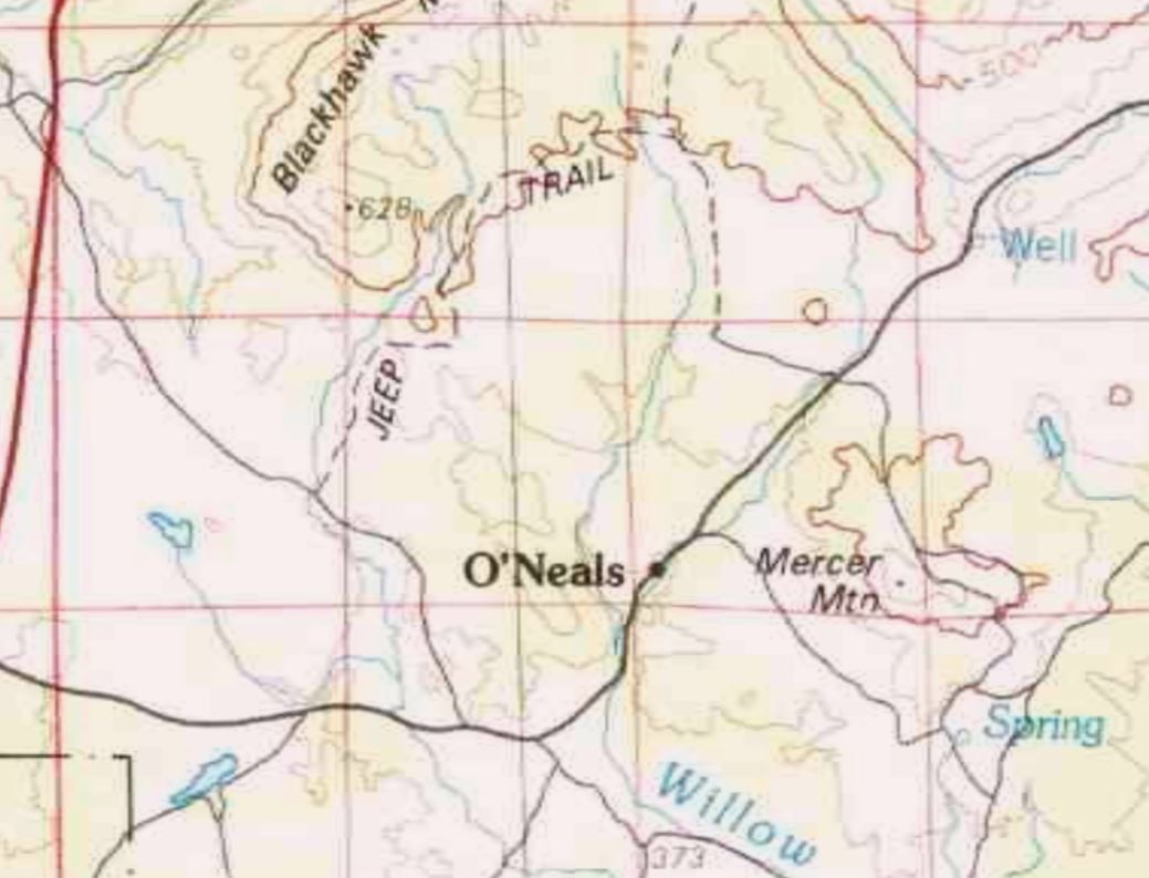
Road 200 can be seen passing through O'Neals for the last time on the 1980 United States Geological Survey Map of Shaver Lake.  Road 200 would appear realigned onto the current bypass whereas the original alignment was shown as Road 201 on the 1981 United States Geological Survey Map of O'Neals.  


Part 2; a drive on Madera County Road 201

Southbound Road 201 can be accessed from Road 200.  Signage indicating Road 201 passes through O'Neals is lacking from the modern bypass.


Road 201 southbound passes through the heart of O'Neals and loops back to Road 200.  The roadway is lined by numerous local businesses, the community Post Office as well as homes.  


Comments

Popular posts from this blog

What's In a Name?: When the Roads Really Do Tell a Story

  Our tagline on the Gribblenation blog is "because every road tells a story". Some roads tell different stories than others. Along our travels, we may see historic markers that tell us a little story about the roads we travel or the places we pass by. Some historic markers are more general, as to telling us who lived where or what old trail traversed between two towns. During my travels across New York State and other states or provinces, I pass by many historic markers, some with interesting or amusing references to roads. I wanted to highlight a few of the markers I've seen along my travels around the Empire State and help tell their stories. Those stories may be as specific as explaining the tales of a tree that was used to help measure a distance of eight miles from Bath to Avoca in Steuben County, as referenced on the Eight Mile Tree historical marker above. They may also help point the way along historical roads first used centuries ago, or may help tell a local l...

2018 Mojave Road Trip Part 2; The deadly desert highway (California State Route 127 and Nevada State Route 373)

After leaving Barstow via Old Highway 58 my next destination was in Death Valley.  To access Death Valley from rural San Bernardino County required a trek on north on Interstate 15 to California State Route 127 which becomes Nevada State Route 373 at the state line. Along I-15 I encountered the road sign oddity that is Zzyzx Road about eight miles south of Baker.   Zzyzx Road is a four mile road that used to go to the Zzyzx Mineral Springs and Health Spa.   The spa was founded in the 1940s and the owner made up the name "Zzyzx" to claim it was the last word in the English Language.  The spa has been shut down since the 1970s and is now part of a Desert Studies Center for California State University. The southern terminus of CA 127 in Baker is located at I-15 exit 246.  CA 127 is a 91 mile north/south highway which runs to the Nevada State Line in Inyo County.  CA 127 is called Death Valley Road from I-15 northward.  South of CA 127 ...

May 2023 Ontario Trip (Part 3 of 3)

  Over the years, I have made plenty of trips to Ontario, crisscrossing the southern, central and eastern parts of the province. Living in Upstate New York, it's pretty easy to visit our neighbor to the north, or is that our neighbor to the west? Ottawa is one of my favorite cities to visit anywhere in the world, plus I've discovered the charm of Kingston, the waterfalls of Hamilton (which is on the same Niagara Escarpment that brings us Niagara Falls), the sheer beauty of the Bruce Peninsula, and more. But I hadn't explored much of Cottage Country. So I decided to change that, and what better time to go than over Memorial Day weekend, when the daylight is long and I have an extra day to explore. On the third and final day of my trip, I started in Huntsville and made my way through Muskoka District and Haliburton County, passing by many lakes along the way. I stopped in towns such as Dorset, Haliburton and Bancroft before making a beeline down to Belleville and then over th...