The Honey Run Covered Bridge is a recently lost structure which was located on Honey Run Road in Butte County, California. The Honey Run Covered Bridge opened to traffic during January 1887 and was part of the highway which connected Chico to Paradise. The Honey Run Covered Bridge was bypassed by the Chico-Paradise Skway during August 1950. The Honey Run Covered Bridge remained open to traffic until 1965 when a truck damaged eastern span the structure. The eastern span of the structure was rebuilt and reopened as a pedestrian span in 1972. The Honey Run Covered Bridge was one of many structures near Paradise destroyed by the Camp Fire on November 8, 2018.
Pictured as the blog cover is the Honey Run Covered Bridge as it was during 1973. This photo was taken by Clark Studio and is now part of the Meriam Library of Cal State Chico photo collection. The Honey Run Road can be seen below as it was displayed on the 1914 Punnett Brothers Map of Butte County.
The history of the Honey Run Bridge
The logging community of Paradise first obtained Post Office service beginning 1877. Originally there was no direct highway linking Paradise west to Chico. The fastest road from Paradise to Chico required detouring south to Roble siding. This early road follows the general corridor of modern Neal Road and can be seen on the 1882 Bancroft's Map of California.
The Carr Hill Bridge was constructed as an uncovered span during 1886 and accepted by the Butte County Board of Supervisors on January 3, 1887. The Carr Hill Bridge was built by the American Bridge & Building Company of San Francisco. The Carr Hill Bridge created a more direct link between Chico-Paradise by crossing Butte Creek.
In 1901 a covering span was placed atop the Carr Hill Bridge and the structure came to be known as the "Honey Run Covered Bridge." The Honey Run Road can be seen below as it was displayed on the 1914 Punnett Brothers Map of Butte County. The Honey Run Bridge can be seen opposite the Butte County Railroad which began service during November 1903.
Honey Run Road can be seen connecting Chico-Paradise on the 1935 Division of Highways Map of Butte County. Honey Run Road from Chico east to Centerville Road is displayed as a major Butte County highway.
Honey Run Road was replaced as the primary highway between Chico-Paradise by the Chico-Paradise Skyway. The construction of the Chico-Paradise Skyway was featured in the January/February 1951 California Highways & Public Works. Money to construct a new highway from Chico to Paradise was appropriated by way of 1943 Legislative Chapter 565 and surveys were conducted by Butte County in 1944. The so-called "Chico-Paradise Skyway" design plans were submitted to the Bureau of Public Roads for consideration as a Federal Aid Secondary program on December 10, 1945. Construction of the Chico-Paradise Skyway would commence during 1948 as Federal Aid Secondary Program 757. The new highway would be opened to traffic as a two-lane expressway aligned alongside the Southern Pacific owned Butte County Railroad on August 30, 1950.
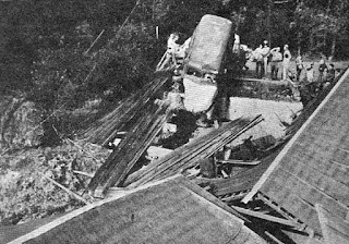
The Honey Run Covered Bridge remained open to traffic until April 12, 1965, when a truck damaged eastern span the structure. The damaged Honey Run Bridge can be seen in the below photo (courtesy Larry Matthews of California's Historic Highways).
The eastern span of the Honey Run Covered Bridge was rebuilt and reopened as a pedestrian span in 1972. Pictured below is the Honey Run Covered Bridge as it was during 1973. This photo was taken by Clark Studio and is now part of the Meriam Library of Cal State Chico photo collection.
The Honey Run Covered Bridge was added to the National Register of Historic Places in 1988. The structure was added due to it being the last known remaining three-span Pratt-type covered bridge in the United States.
The Honey Run Covered Bridge was one many structures destroyed near Paradise destroyed by the Camp Fire on November 8, 2018. The Camp Fire was deadliest fire in California history and claimed 85 lives. Only 5% of the structures in the city of Paradise remained standing after the community was ravaged by the Camp Fire. The ruins of the Honey Run Covered Bridge can be seen in the image link below from the November 9, 2018, Chico-Enterprise Record.


Comments