
Former California State Route 215


California State Route 215 was a short-lived state highway which existed in the Los Angeles Metropolitain area after the 1964 State Highway Renumbering.  California State Route 215 was aligned from US Route 60 at 5th Street in Pomona north to US Route 66 near Claremont via Garey Avenue.  California State Route 215 came to be after California State Route 71 was bisected in Pomona due to relinquishment of a portion of Garey Avenue due to the opening of a portion of the Corona Freeway (now Chino Valley Freeway) during 1958.  California State Route 215 was deleted by the Legislature during 1965.


The history of California State Route 215

The initial segment of what was to become California State Route 215 was added to the State Highway System as part of the 1909 First State Highway Bond Act.  The First State Highway Bond Act defined what would become Legislative Route Number 19 (LRN 19) as running from Claremont to Riverside.  The segment of LRN 19 between Claremont and Pomona would in time become part of California State Route 71.  LRN 19 can be seen on the 1918 California Highway Commission Map.  The routing of LRN 19 between Claremont and Pomona followed Garey Avenue.  


California State Route 71 was announced as one of the original Sign State Routes in the August 1934 California Highways & Public Works.  California State Route 71 originated at US Route 66 near Claremont and followed LRN 19 south towards Pomona.  From Pomona, California State Route 71 followed the entirety of LRN 77 to US Route 80 near San Diego.  


In 1935 the Division of Highways released County maps which depict routing of California State Route 71.  Within Los Angeles County, California State Route 71 is shown following Garey Avenue along LRN 19 south from US Route 66/LRN 9 in Claremont to US Route 99/US Route 60/US Route 70/LRN 26 at Holt Avenue in Pomona.  California State Route 71 briefly multiplexed US Route 60/LRN 19 on Garey Avenue south to 5th Street where the latter split east towards Riverside.  California State Route 71 transitioned onto LRN 77 following Garey Avenue and Philadelphia Street to the San Bernardino County line.  


The 1936-1937 Division of Highways Map displays California State Route 71/LRN 77 south of Pomona bypassing Chino via an extension of Garey Avenue.  The new bypass of Chino tied into Merrill Avenue south of the city of limit of Chino directly towards LRN 177.  

The January/February 1958 California Highways & Public Works announced a contract to construct the Temescal Freeway between 5th Street to 0.9 miles south of Riverside Drive in Pomona.  The initial segment of the Temescal Freeway is noted to have an anticipated completion during April as an expressway.  While not overly stated the Temescal Freeway was intended to be the new alignment of California State Route 71.  


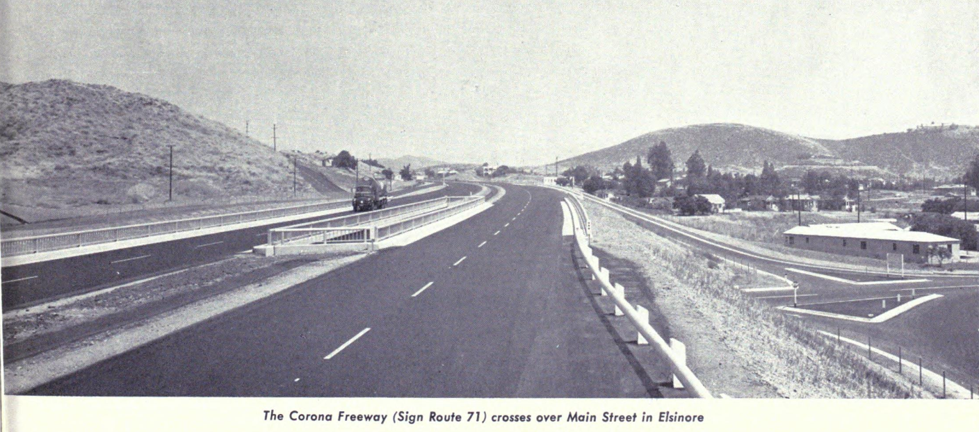
The Temescal Freeway name was short lived as the corridor was announced as having been named the "Corona Freeway" in the November/December 1958 California Highways & Public Works.  The Corona Freeway name was selected by the California Highway Commission on July 23, 1958.  The Corona Freeway corridor is noted to have been selected by the California Highway Commission during 1947 between the Los Angeles County line and the US Route 395 Escondido Freeway.  


The 1959 Division of Highways Map displays California State Route 71 in Pomona as a bisected highway.  The northern segment of California State Route 71 is shown to follow LRN 19 between Claremont to the US Route 60 along Garey Avenue.  The segment of Garey Avenue south to the Corona Freeway is shown to have been relinquished back to Pomona.  The southern Segment of California State Route 71 is shown originating at US Route 60 and following the Corona Freeway south towards Chino.  The entire Corona Freeway corridor had been added the Freeway & Expressway System during 1959.  


The 1964 State Highway Renumbering heavily altered the corridor of California State Route 71.  The Legislative Route Numbers were dropped as part of the 1964 State Highway Renumbering in favor of Sign Route designations.  California State Route 71 was defined with several segments:

(A) Route 10 to near Pomona to Route 91 via Pomona.
(B) Route 91 to Route 395.
(C) Route 395 near Temecula to Route 74 east of Anza.  

The 1964 Division of Highways Map displays the changes to California State Route 71.  What had been California State Route 71 along Garey Avenue between US Route 66 in Claremont to US Route 60 in Pomona was designated as California State Route 215.  The establishment of California State Route 215 removed the gap in California State Route 71.  California State Route 71 was extended north of US Route 60/5th Street to the Interstate 10 and the San Bernardino Freeway.  


1965 Legislative Chapter 1372 deleted California State Route 215 along Garey Avenue between Claremont and Pomona.  It is unclear if California State Route 215 ever had any signage or was signed as California State Route 71 prior to being deleted.  Former California State Route 71/California State Route 215 along Garey Avenue between Claremont and Pomona no longer appears on the 1966 Division of Highways Map.  


Comments

Popular posts from this blog

North Carolina Continues to Move Forward with Rail

2023 and the first half of 2024 have seen continued growth in North Carolina's passenger rail system.  From increased daily trains from Raleigh to Charlotte, federal funds for studying additional corridors, and receiving a historic grant to begin the construction of high-speed rail between Raleigh and Richmond, the last 18 months have been a flurry of activity at NCDOT's Rail Division.  And that's just the tip of the iceberg. As ridership and routes increase - the engine of North Carolina passenger rail trains will become a more common sight. (Adam Prince) Increased Passenger Train Service: On July 10, 2023, a fourth Piedmont round-trip rail service between Raleigh and Charlotte commenced.  The four Piedmont trains plus the daily Carolinian (to Washington, DC, and New York) bring the total of trains serving the two cities daily to five. The current daily Piedmont and Carolinian schedule between Charlotte and Raleigh (NCDOT) The result was over 641,000 passengers utilized pa

US Route 101 in Benbow, Garberville and Redway

The communities of Benbow, Garberville and Redway can all be found along US Route 101 within southern Humboldt County.  The former surface alignment of US Route 101 in Garberville and Redway once crossed the Garberville Bluffs along what is now Redwood Drive via a corridor constructed as part of the Redwood Highway during the 1910s.  US Route 101 through Benbow, Garberville and Redway was modernized by 1935.  US Route 101 would eventually be upgraded to freeway standards in Benbow, Garberville and Redway by extension of the Redwood Freeway during 1966-68.  As the cover photo the original grade of US Route 101 and the Redwood Highway can be seen at the Garberville Bluffs during 1934.  US Route 101 can be seen in the communities of Benbow, Garberville and Redway on the 1935 Division of Highways Map of Humboldt County .   The history of US Route 101 in Benbow, Garberville and Redway Benbow, Garberville and Redway lie on the banks of the South Fork Eel River of southern Humboldt County.  D

The Midway Palm and Pine of US Route 99

Along modern day California State Route 99 south of Avenue 11 just outside the City limits of Madera one can find the Midway Palm and Pine in the center median of the freeway.  The Midway Palm and Pine denotes the halfway point between the Mexican Border and Oregon State Line on what was US Route 99.  The Midway Palm is intended to represent Southern California whereas the Midway Pine is intended to represent Northern California.  Pictured above the Midway Palm and Pine can be seen from the northbound lanes of the California State Route 99 Freeway.   This blog is part of the larger Gribblenation US Route 99 Page.  For more information pertaining to the other various segments of US Route 99 and it's three-digit child routes check out the link the below. Gribblenation US Route 99 Page The history of the Midway Palm and Pine The true timeframe for when the Midway Palm and Pine (originally a Deadora Cedar Tree) were planted is unknown.  In fact, the origin of the Midway Palm and Pine w