
The 1928 Iowa Hill Road Bridge


The 1928 Iowa Hill Road Bridge is a derelict structure located in the Sierra Nevada Mountains of Placer County, California.  The 1928 Iowa Hill Road Bridge can be found between the communities of Colfax and Iowa Hill.  The 1928 Iowa Hill Road Bridge is a wire suspension structure which spans the North Fork American River.  The 1928 Iowa Hill Road Bridge was replaced by a modern span and converted to pedestrian use following floods during 1963.  


Part 1; the history of the 1928 Iowa Hill Road Bridge

During 1853 gold was discovered at what to become Iowa Hill.  The gold mining claims soon led to a small community known as Iowa City being established.   By 1854, Post Office Service began at the mines of Iowa City.  By 1856 gold production at Iowa City was estimated to be around $100,000.  Iowa City was burned in fires during 1857 and 1862 but the community was rebuilt with more modernized structures.  

The location of Iowa City can be seen as "Iowa Hill" on the 1873 Bancroft's Map of California.  Iowa Hill is shown to be a short distance east of Colfax in rural Placer County with no major roads connecting the communities.  


Iowa Hill can be seen connected to Colfax via a road (now Iowa Hill Road) over the North Fork American River on the 1882 Bancroft's Map of California.  


In 1901 the Postal Service officially changed the name of Iowa City to "Iowa Hill."  Iowa Hill Road can be seen in great detail of the 1914 C.F. Weber Map of Placer County.  Iowa Hill Road is shown with a bridge crossing the North Fork American River, it is unclear what type of span this was.  


Iowa Hill burned for a final type during 1920.  Though diminished by fire and the decline mining the community of Iowa Hill persisted.  During 1928 a then new wire suspension bridge was constructed along Iowa Hill Road at the North Fork American River.  The location of the 1928 Iowa Hill Bridge can be seen along Iowa Hill Road on the 1935 Division of Highways Map.  Iowa Hill Road is noted to be a major Placer County road.  


A car can be seen crossing the 1928 Iowa Hill Bridge can be seen in a 1950s era photo (courtesy bridgerhunter.com).


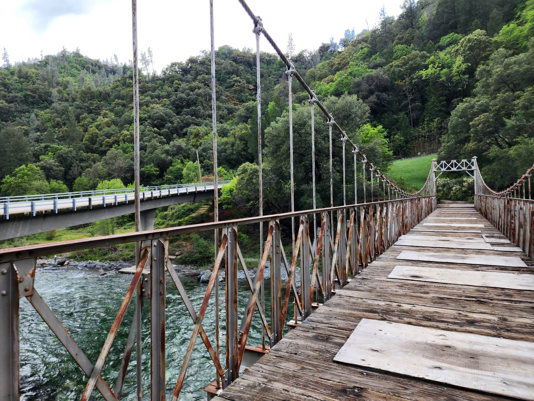
During February 1963 the 1928 Iowa Hill Bridge was partially washed out by floods on the North Fork American River.  A new bridge was erected directly to the south as the new alignment of Iowa Hill Road.  The 1928 Iowa Hill Bridge was subsequently retained as part of the Mineral Bar Campground. 


Part 2; visiting the 1928 Iowa Hill Bridge

During May 2023 Josh Schmid visited the 1928 Iowa Hill Road Bridge after the May 6, 2023, Fresno Road Meet.  The below collection of photos was taken by Josh during his visit.  


Comments

Popular posts from this blog

Bleriot Ferry - Alberta

  Alberta operates six ferries scattered throughout the province. Roughly twenty to twenty-five kilometers up the Red Deer River from the town of Drumheller is one of the most scenic ferry crossings in all of Wild Rose Country, the Bleriot Ferry. Using the North Dinosaur Trail (Alberta Highway 838, or AB 838), the Bleriot Ferry provides a scenic river cruise of sorts in the Canadian Badlands. The Bleriot Ferry started operating in 1913 as the Munson Ferry when a few bridges crossed the Red Deer River. The ferry was started by Andre Bleriot, the brother of famed early aviator Louis Bleriot, who became famous for being the first person to fly over the English Channel. At the time, the Alberta provincial government commissioned local residents to run the ferries. There were several ferries along the Red Deer River, and not only did they serve as vital transportation links, but they also served as local social hubs, since everyone had to take the ferries to go places. Over time, as the...

Interstate 40's Tumultuous Ride Through the Pigeon River Gorge

In the nearly 60 years Interstate 40 has been open to traffic through the Pigeon River Gorge in the mountains of Western North Carolina, it has been troubled by frequent rockslides and damaging flooding, which has seen the over 30-mile stretch through North Carolina and Tennessee closed for months at a time. Most recently, excessive rainfall from Hurricane Helene in September 2024 saw sections of Interstate 40 wash away into a raging Pigeon River. While the physical troubles of Interstate 40 are well known, how I-40 came to be through the area is a tale of its own. Interstate 40 West through Haywood County near mile marker 10. I-40's route through the Pigeon River Gorge dates to local political squabbles in the 1940s and a state highway law written in 1921. A small note appeared in the July 28, 1945, Asheville Times. It read that the North Carolina State Highway Commission had authorized a feasibility study of a "...water-level road down [the] Pigeon River to the Tennessee l...

I-73/I-74 and NC Future Interstates Year in Review 2024

Welcome to another annual review of progress in constructing North Carolina's New and Future Interstate routes. While 2024 was not too exciting, with no new segments of major routes opening, there was 1 new interstate signing, another proposed new interstate route, and the near opening of a new segment for 2 routes. As tradition, I will start off with a review of what happened with I-73 and I-74 and then move on to the major news of the year about the other new and future routes. Work continued on the I-73/I-74 Rockingham Bypass through the year. The last few months have been hoping for news of its opening before 2025, without luck. Signs of its near completion included the placement of new signs, many with interstate shields uncovered, along the Bypass and intersecting roadways. For example, these went up along US 74 East: Overhead signage at Business 74 exit which contains the future ramp to I-73 North/I-74 West. Signage was also updated heading west on US 74 approaching the unop...