
Florida State Road 700 is largely a hidden designation for much of US Route 98 between Homosassa Springs in Citrus County and Canal Point in Palm Beach County. Florida State Road 700 is co-signed with US Route 98 and US Route 441 from Okeechobee to Canal Point along the east shore of Lake Okeechobee. Florida State Road is independently signed from Canal Point southeast along Conners Highway for approximately 14 miles. The only other location where Florida State Road 700 is signed as a standalone route is the Hernando County seat of Brooksville. Florida State Route 700 briefly branches from US Route 98 as an independent route in Brooksville at Jefferson Street southward 0.330 miles on Ponce de Leon Boulevard to US Route 41/Broad Street.

Part 1; the history of Florida State Road 700 in Brooksville
What is now Florida State Road 700 on Ponce de Leon Boulevard in Brooksville is displayed as a component of pre-1945 Florida State Road 15 on the 1936 Florida State Road Department Map of Hernando County. Florida State Road 15 is shown passing through Brooksville eastbound via Fort Dade Avenue, Ponce de Leon Boulevard and Broad Street. Florida State Road 15 is shown to carry US Route 41 and US Route 19 departing Brooksville on Broad Street. Early US Route 19 in Florida was carried by Florida State Road 15 west of Brooksville.

The pre-1945 Florida State Road numbers were assigned in the order they were adopted by the legislature. The post-1945 Florida State Road system was grid based much like the US Route System. Odd numbered one/two-digit State Roads were assigned to north/south routes which ascended westward. Even one/two-digit State Roads were assigned to east/west routes which ascended southward. What had been Florida State Road 15 through much of Brooksville was initially reassigned as part of Florida State Road 50.
Florida Road 50 can be passing through Brooksville on the 1948 Rand McNally Map of Florida. Early Florida State Road 50 can be seen following Fort Dade Avenue, Ponce de Leon Boulevard, Board Street and Jefferson Street. Between Ponce de Leon Boulevard and Jefferson Street, Florida State Road 50 was concurrent with US Route 41.

US Route 98 was extended on November 23, 1951, by the American Association of State Highway Officials from Apalachicola to Palm Beach following a request from the Florida State Road Department.

A letter from the Florida State Road Department dated September 10, 1951, noted that US Route 98 would almost be entirely concurrent Florida State Road 700. The X00 State Roads are noted to have been intentionally set up as part of the 1945 State Road Renumbering to permit travelers with a series of streamlined diagonal State Roads through the state.


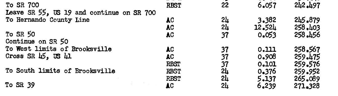
A September 1951 Florida State Road Department log for the proposed extension of US Route 98 shows Florida State Road 700 was to be an independent routing in Brooksville. As originally defined US Route 98 through Brooksville followed the recently realigned Florida State Road 50 east along Jefferson Street.

Part 2; a drive on Florida State Road 700 in Brooksville
Florida State Road 700 in Brooksville appears on southbound Ponce de Leon Boulevard as US Route 98 eastbound turns onto Jefferson Street with Florida State Road 50A.

Florida State Road 700 follows Ponce de Leon Boulevard southward towards US Route 41 at Broad Street. Florida State Road 700 does not make another posted appearance until Palm Beach County.


Comments