Since the inception of the US Route System the history of US Route 101 has been significantly tied to the city of Los Angeles. The original surface alignment of US Route 101 was signed in Los Angeles during 1930 following Boyle Avenue, Plesant Avenue, Macy Street, Main Street, Sunset Boulevard, Cahuenga Boulevard and Ventura Boulevard. From 1940 through 1960 US Route 101 in Los Angeles would be shifted gradually to the Hollywood Freeway, Santa Ana Freeway and Ventura Freeway. US Route 101 was truncated from the Mexican Border to Interstate 5 in Los Angeles along the Santa Ana Freeway during 1963. Featured as the blog cover is the Cahuenga Pass Freeway (now Hollywood Freeway) during 1940 approaching Cahuenga Boulevard and Highland Avenue.

Part 1; the history of US Route 101 in Los Angeles
Los Angeles was part of the American El Camino Real which began being signed as an Auto Trail starting in 1906. The era of State Highway Maintenance to Los Angeles would ultimately begin with the 1909 First State Highway Bond Act which was approved by voters in 1910. One of the highways approved through the 1909 First State Highway Bond Act was a 481.8-mile highway originating at the City Limits of San Francisco which terminated in San Diego. This highway would ultimately come to be known in time as Legislative Route Number 2 ("LRN 2").
Although Los Angeles was serviced by LRN 2 the through highway in the city was maintained locally. The California Highway Commission would be prevented from maintaining highways in incorporated cities outside of cooperative projects until 1933.
During the 1913 the Pacific Highway was established as an organized Auto Trail Association borne out of the Good Roads movement. The Pacific Highway was applied over the north/south highway connecting the discontinuous LRN 2 through Los Angeles. The gap in LRN 2 through Los Angeles can be seen on the 1917 California State Automobile Association Map. LRN 2 (seen in red) can be seen entering the Los Angeles city limit via Cahuenga Boulevard and departing south of downtown via Whittier Boulevard.
The Pacific Highway, El Camino Real and the Coast Highway can be seen passing through Los Angeles bridged by LRN 2 on the
1920 Clason Map of California.

The initial draft of the US Route System was approved by the Secretary of Agriculture during November of 1925. The US Route System within California was approved by California Highway Commission with no changes recommended by
January 1926. The initial alignment of US Route 101 was planned to follow LRN 2 from San Francisco to San Diego via Los Angeles. US Route 101 is shown on a map published in the 1926 California Highways & Public Works following LRN 2 south from San Francisco to Los Angeles.
The
September 1926 California Highways & Public Works features numerous photos of an improved LRN 2 on Ventura Boulevard between Calabasas and Hollywood. The city of Los Angeles annexed much of San Fernando Valley during the 1910s and 1920s which included state-maintained portion of LRN 2 along Ventura Boulevard. Much of LRN 2 along Ventura Boulevard is cited to have a width of 90 feet.
On November 11, 1926, the American Association of State Highway Officials (AASHO) approved the US Route System which brough US Route 101 formally into existence. US Route 101 appears on the November 11, 1926, AASHO descriptions of the US Routes in California with Los Angeles as a control city.


Signing of the US Routes within in California did not begin until 1928. The
Los Angeles City Council meeting notes (courtesy MapMikey) from February 5, 1930, explicitly stated that the US Routes were not yet signed within Los Angeles. The Los Angeles City Council did elect have the Automobile Club of Southern California (ACSC) sign US Route 99 and US Route 101 during the February 5, 1930, meeting but not US Route 66.
From the southern city limit of Los Angeles at Whittier Boulevard US Route 101 was to be signed following Boyle Avenue, Pleasant Avenue, Macy Street (now Cesar Chavez Avenue), Main Street, Sunset Boulevard and Cahuenga Boulevard. US Route 101 was to follow Cahuenga Boulevard via Cahuenga Pass to San Fernadno Valley and Ventura Boulevard.
The initial alignment of US Route 101 (in blue) in Los Angeles can be seen displayed on a late 1931 map by the Division of Highways submitted to AASHO regarding a proposed split of alignment of US Route 66 in the city.
During 1933 the legislative barriers preventing the California Highway Commission from maintaining State Highways within incorporated cities was lifted. Thusly, the gap of LRN 2 through was Los Angeles by way of following existing US Route 101 was filled.
The September 1933 California Highways & Public Works referenced a grade separation being funded for US Route 101 on Sunset Boulevard at Glendale Boulevard.
The
June 1934 California Highways & Public Works featured construction of the Sunset-Glendale Viaduct along US Route 101/LRN 2. The Sunset-Glendale Viaduct is noted to be a replacement for a 29-year-old timber trestle which carried Sunset Boulevard over Glendale Boulevard. Construction of the Sunset-Glendale Viaduct is noted to have required US Route 101/LRN 2 traffic to utilize a temporary detour.
The
October 1934 California Highways & Public Works featured the completed Sunset-Glendale Viaduct. The Sunset-Glendale Viaduct is noted to have opened to traffic on October 1, 1934.
On June 14, 1935, the California State Highway Engineer submitted a request to extend US Route 66 from the intersection of Broadway and Sunset Boulevard in Los Angeles to the intersection of Lincoln Boulevard and Pennsylvania Avenue in Santa Monica. The planned extension of US Route 66 would multiplex US Route 101 from Broadway in downtown Los Angeles via Sunset Boulevard to Santa Monica Boulevard.
The California State Highway Engineer acknowledges in a letter dated to July 6, 1935, that the AASHO Executive Committee had approved the extension of US Route 66 to Santa Monica.


An opening ceremony for the fourth Figueroa Street Tunnel was held on August 4, 1936, which was featured in the Los Angeles Times. The completion of the fourth Figueroa Street Tunnel connected US Route 99/US Route 66/California State Route 11/LRN 165 directly to US Route 101/LRN 2 at Sunset Boulevard.
The
1940 Division of Highways Map depicts California State Route 26 with a gap originating at the eastern terminus of LRN 173 at Indiana Street in Los Angeles. Much of what had been California State Route 26 on Anaheim-Telegraph Road (LRN 166) was designated as US Route 101 Bypass. US Route 101 Bypass is shown to originate at the intersection of Whittier Boulevard and Indiana Street. US Route 101 Bypass followed LRN 166 south on Indiana Street to Anaheim-Telegraph Road. From Anaheim-Telegraph Road, US Route 101 Bypass is shown following Lakewood Boulevard (LRN 168), Firestone Boulevard (LRN 174) and Manchester Boulevard (LRN 174) to Anaheim. Mainline US Route 101 east of the Los Angeles city limit is still shown following Whittier Boulevard, Spadra Road and Los Angeles Street between Los Angeles-Anaheim.


The
July 1940 California Highways & Public Works featured the first opened segment of the Cahuenga Pass Freeway as a new limited access corridor of US Route 101/LRN 2 in the Santa Monica Mountains. The Cahuenga Pass Freeway opened on June 15, 1940, between the intersection of Cahuenga Boulevard/Highland Avenue north approximately one mile to Cahuenga Pass. The Cahuenga Pass Freeway is noted to be part of the larger planned Hollywood Parkway. The Hollywood Parkway was planned to begin in downtown Los Angeles and extend north to Ventura Boulevard. The Cahuenga Pass Freeway is noted to have been a cooperative project between the State, City of Los Angeles and Federal Government. Upon the initial segment of the Cahuenga Pass Freeway opening the Pacific Electric Railway tracks ran in the center median.


1941 Legislative Chapter 142 altered the definition of LRN 166 by way of changing the defined endpoints. The new definition of LRN 166 was follows:
"LRN 172 (3rd Street) at the intersection of Downey Road to LRN 174 near Norwalk."
LRN 166 between 3rd Street and 9th Street is shown shifted from Indiana Street to Downey Road on the 1942 Division of Highways Map. LRN 166 on Downey Road between Whittier Boulevard and 9th Street is shown to be a component of US Route 101 Bypass.
The
July/August 1944 California Highways & Public Works features the nearly completed interchange between the Ramona Parkway (US Route 99-60-70) and planned Santa Ana Parkway. The Santa Ana Parkway was a planned as a realignment of US Route 101 south of downtown Los Angeles. The interchange between the Ramona Parkway and Santa Ana Parkway is noted to have a planned completion date of August 15, 1944.


The
January/February 1946 California Highways & Public Works announced the planned Hollywood Parkway would extend south from Highland Avenue alongside Sunset Boulevard to the Aliso Street Viaduct. The general corridor of the planned Santa Ana Parkway is described as extending south from the Aliso Street Viaduct to Santa Ana.
The
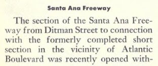
July/August 1948 California Highways & Public Works featured the opening of the initial segment of the Santa Ana Freeway. The Santa Ana Freeway opened between the Aliso Street Viaduct 1.6 miles south to Soto Street. The Santa Ana Freeway corridor alignment was adopted by the California Highway Commission between Euclid Avenue in Los Angeles to the southern Anaheim city limit on October 28, 1939. The article is unclear if the initial segment of the Santa Ana Freeway was signed as US Route 101 or part of US Route 101 Bypass.


The
January/February 1949 California Highways & Public Works features an update on the construction of the Four Level Interchange. The Four Level Interchange is stated to be nearing completion. The article stub notes the Four Level Interchange would link the Arroyo Seco Parkway via a limited access grade to the Hollywood Parkway and Harbor Parkway. Construction of the Four Level Interchange once complete would eventually link the Arroyo Seco Parkway south from Adobe Street. The first photo displays existing US Route 101 on Sunset Boulevard crossing the Arroyo Seco Parkway.
The cover of the
March/April 1949 California Highways & Public Works featured the Hollywood Freeway in Cahuenga Pass. The cover caption notes the Cahuenga Pass Freeway was now considered part of the Hollywood Freeway. The caption also notes the corridor of the Hollywood Freeway recently was extended north to Vineland Avenue.
The
May/June 1949 California Highways & Public Works article featured the razing of Fort Moore Hill to make way for the Hollywood Freeway. The contract to construct the Hollywood Freeway from Fort Moore Hill to the Los Angeles Civic Center was awarded on January 18, 1949. The leveling of Fort Moore Hill included the removal the Broadway Tunnel which was once part of the National Old Trails Road. The Broadway Tunnel was constructed during 1901.
The
May/June 1949 California Highways & Public Works featured the opening of the Santa Ana Freeway from Soto Street to Eastman Avenue in East Los Angeles. The Soto Street-Eastman Avenue segment of the Santa Ana Freeway is noted to have opened without ceremony on April 4, 1949.
The completed Four Level Interchange appears on the cover of the
September/October 1949 California Highways & Public Works.

The
May/June 1950 California Highways & Public Works featured the opening of the Santa Ana Freeway from Eastman Avenue to La Verne Avenue in East Los Angeles. The Eastman Avenue-La Verne Avenue corridor of the Santa Ana Freeway opened to traffic on April 12, 1950, and connected to US Route 101 Bypass/LRN 166 at Anaheim-Telegraph Road.
The
July/August 1950 California Highways & Public Works provided an update to the progression of the Hollywood Freeway. The 1.6 miles of the Hollywood Freeway between Glendale Avenue and Virgil Avenue is noted to be approximately 80% complete with anticipated completion coming in October.
The
January/February 1951 California Highways & Public Works recapped the removal of Fort Monroe Hill in downtown Los Angeles to make way for the Hollywood Freeway.
The
January/February 1951 California Highways & Public Works cover featured a newly opened segment of the Hollywood Freeway north of downtown Los Angeles. The photo caption notes the segment to have opened to traffic on December 27, 1950. An accompanying article features the opening of the Hollywood Freeway between Grand Avenue and Silver Lake Boulevard. The completion of the Grand Avenue-Silver Lake Boulevard segment connected it to the Four Level Interchange.
The
May/June 1951 California Highways & Public Works featured a progress report on the then 17 remaining active construction projects on the Hollywood Freeway. The report notes the Hollywood Freeway was expected to be completed from the Los Angeles Civic Center north to Vineland Avenue at some point during 1953.
The
July/August 1951 California Highways & Public Works featured the opening of the connection between the Hollywood Freeway and Harbor Freeway via the Four Level Interchange on June 27, 1951.


The
January/February 1952 California Highways & Public Works featured the opening of the segment of the Hollywood Freeway to the Los Angeles Civic Center. The Hollywood Freeway was opened to traffic from the Four Level Interchange to the Los Angeles Civic Center on December 20, 1951.
The
January/February 1952 California Highways & Public Works announced the Santa Ana Freeway (US Route 101 Bypass) was expected to be complete between Rosemead Boulevard and the Los Angeles Civic Center by late year 1952 or early 1953. The article notes US Route 101 Bypass traffic would still need to utilize Lakewood Boulevard and Firestone Boulevard due the Santa Ana Freeway east of Rosemead Boulevard to Norwalk not likely opening for several more years.


The 1953 Division of Highways Map depicts a new spur routing of LRN 2 existing as part of the Santa Ana Freeway west of Downey Road/LRN 166 towards downtown Los Angeles. LRN 166 along Downey Road is shown connecting as south of Whittier Boulevard to the Santa Ana Freeway. It isn't clear if the Santa Freeway west of Downey Road was signed as US Route 101 or US Route 101 Bypass.
The
March/April 1953 California Highways & Public Works announced the Hollywood Freeway was opened north of downtown Los Angeles between Western Avenue to Hollywood Boulevard on March 16, 1953.


The
March/April 1953 California Highways & Public Works noted US Route 101 Bypass on the Santa Ana Freeway was expected to open to Slauson Avenue by April 1953. The extension of the Santa Ana Freeway to Santa Ana is stated to be planned for completion sometime during 1954. The segment of the Santa Ana Freeway from Lyon Street to the Los Angeles Civic Center is noted to have an anticipated completion date sometime during 1953.


The
1954 Division of Highways Map shows the Santa Ana Freeway completed to Pioneer Boulevard near Norwalk. Mainline US Route 101 is shown realigned onto the Santa Ana Freeway (LRN 166), an interim routing on Pioneer Boulevard and Firestone Boulevard/Manchester Boulevard (LRN 174) between Los Angeles-Anaheim. The former mainline of US Route 101 on LRN 2 is shown to no longer be part of the highway. US Route 101 is shown shifted onto the Hollywood Freeway south of Sunset Boulevard in Hollywood through downtown Los Angeles. US Route 66 moved to a multiplex of US Route 101 along the Hollywood Freeway from the Arroyo Seco Parkway to Santa Monica Boulevard.


The
May/June 1954 California Highways & Public Works featured the last segment of the Hollywood Freeway to open between Hollywood Boulevard to Cahuenga Pass. The Hollywood Boulevard-Cahuenga Pass segment of the Hollywood Freeway opened to traffic on April 15, 1954. The article references the Pacific Electric Railway right-of-way in the center median being repurposed to complete the last segment of the Hollywood Freeway. The combined completed grades of the Santa Ana Freeway and Hollywood Freeway are noted to contain a 24-mile-long continuous limited access grade from Pioneer Boulevard in Norwalk to Vineland Avenue in San Fernando Valley.


The
1955 Division of Highways Map displays US Route 101 fully realigned onto the Hollywood Freeway and Santa Ana Freeway from San Fernando Valley south through downtown Los Angeles. The former surface routing of US Route 101 on Cahuenga Boulevard, Sunset Boulevard, Macy Street, Pleasant Avenue and Boyle Avenue are shown to be relinquished.
The
January/February 1955 California Highways & Public Works noted the California Highway Commission had adopted 16 miles of the Ventura Freeway within Los Angeles. The Ventura Freeway is noted to be a segment of US Route 101/LRN 2 spanning from the Hollywood Freeway west to the Santa Barbara County Line. The volume notes 32.7 miles of the Ventura Freeway outside the Los Angeles city limit was already complete.
On June 29, 1956, the Federal Highway Aid Act of 1956 was signed into law on the Federal Level. The Federal Highway Aid Act of 1956 was the genesis point of the Interstate Highway System which would in the coming decade see US Route 101 truncated to Los Angeles.
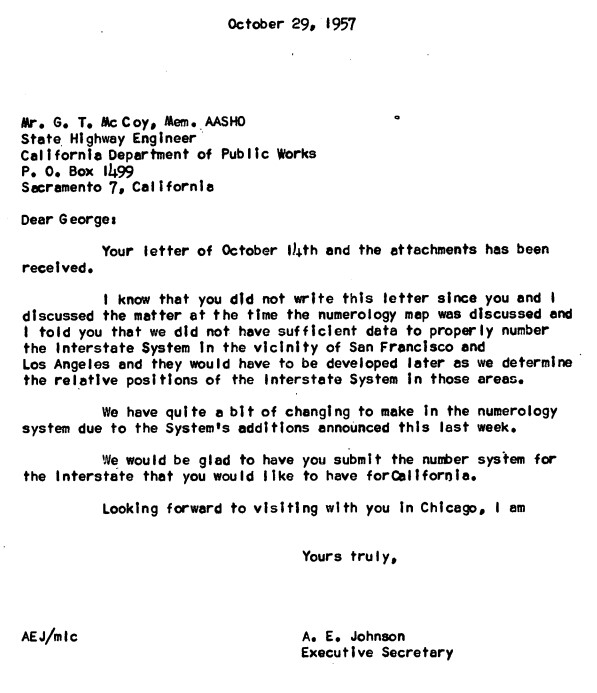
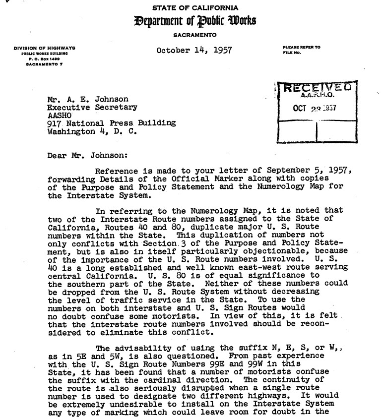
A series of October 1957 communications between the AASHO Executive Secretary and California State Highway Engineer reveal the entirety of California's initial run of chargeable Interstates. The major Interstate corridors described above are shown to have had route numbers been approved by the Commissioner of Public Roads during May 1957.
The California State Highway Engineer asked for numerous numbering changes and additions. Notably there was not a request to assign a number to corridor H which included a segment of the San Bernardino Freeway and Santa Ana Freeway in downtown Los Angeles.
The adopted routing of the Ventura Freeway west of the Hollywood Freeway appears on the
1958 Division of Highways Map.

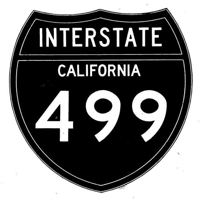
A letter dated April 1, 1958, from the California State Highway Engineer to the AASHO Executive Secretary contained new proposal for short three-digit Interstates along with two three-digit Interstate shield designs. The three-digit Interstate shield designs contained one variation with the State name and another lacking it. The proposed Interstate numbers in California changed drastically from the December 1957 plan. Interstate 106 was proposed for the downtown corridors of the Santa Ana Freeway and San Bernardino Freeway.


A letter dated August 7, 1958, from the California State Highway Engineer to the AASHO Executive Secretary contained a new draft for the Interstate numberings in California subsequent to the urban route numbering conventions being established during July 1958. The August 1958 proposal was close to the finalized numbering conventions in California but had some differences in the San Francisco Bay Area. The Interstate corridors of downtown Los Angeles matched what they ultimately would become with Interstate 105 being assigned to the Santa Ana Freeway from San Bernardino Freeway south to the Golden State Freeway.


The
May/June 1960 California Highways & Public Works featured the opening of the last two segments of the Ventura Freeway in San Fernando Valley west of the Hollywood Freeway. A dedication ceremony opening the last two segments of the Ventura Freeway was held on April 5, 1960. Upon the completion of the Ventura Freeway west of the Hollywood Freeway the entirety of US Route 101 in Los Angeles was brought up to freeway standards.
On June 19, 1963, AASHO approved a Division of Highways request to truncate US Route 101 from the Mexican border to Interstate 5 and the Golden State Freeway in Los Angeles. US Route 101 was functionally made concurrent with Interstate 105 along the Santa Ana Freeway from Interstate 110 at the western end of the San Bernardino Freeway to Interstate 5 at the Golden State Freeway.
US Route 66 was approved to be truncated from Santa Monica to US Route 95 in Needles by the AASHO on November 14, 1963. US Route 66 was effectively immediately removed from the Hollywood Freeway and Pasadena Freeway (formerly the Arroyo Seco Parkway) with signage being truncated to Pasadena. This measure only left US Route 101 signed on the Hollywood Freeway in downtown Los Angeles.
As part of the 1964 State Highway Renumbering the Legislative Route Numbers were dropped of Sign Route designations. The legislative definition of US Route 101 noted it ended at the junction of Interstate 105 and 110 in downtown Los Angeles. This definition contradicted the approved truncation of US Route 101 by AASHO to Interstate 5. The new definition of
US Route 101 and
Interstate 105 both appear on the 1964 Division of Highways Map. California State Route 2 can be seen multiplexing US Route 101 along the Hollywood Freeway from Alvarado Street to Santa Monica Boulevard.
1968 Legislative Chapter 282 eliminated the original Interstate 105 and extended US Route 101 legislatively to Interstate 5 near 7th Street in Los Angeles. The new legislative definition of US Route 101 ending at Interstate 5 first appears on the
1969 Division of Highways Map.
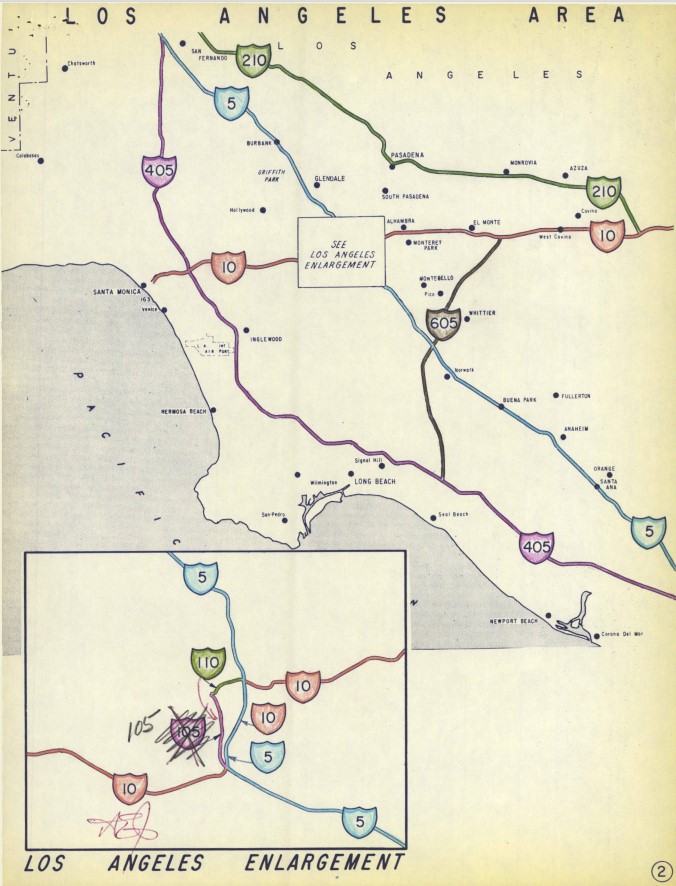
Part 2; a drive on US Route 101 and Hollywood Freeway from the Ventura Freeway to the Four Level Interchange
At the interchange with California State Route 134 and Ventura Freeway, California State Route 170 southbound terminates on the Hollywood Freeway Extension. The Hollywood Freeway continues onto US Route 101 south towards downtown Los Angeles via Cahuenga Pass.
Cahuenga Pass was part of the Spanish El Camino Real and was the site of two battles during Mexican Rule. Cahuenga Pass is the lowest mountain pass in the Santa Monica Mountains at 745 feet above sea level.
US Route 101 Exit 12B accesses Vineland Avenue.
US Route 101 southbound on the Hollywood Freeway approaching Cahuenga Pass.
US Route 101 Exit 12A access to Lankershim Boulevard and Cahuenga Boulevard.
The bridge work on the US Route 101 portion of the Hollywood Freeway tends retain some of the classic Arc Deco aesthetic. In the first photo below the Barham Boulevard Bridge can be seen. According to Daniel Faigin of CAhighways.org the clips of the electric trolley line can be seen beneath the Barham Boulevard Bridge.
Access to the Hollywood Museum can be found at US Route 101 Exit 9C towards Highland Avenue.
US Route 101 Exit 9 accesses Cahuenga Boulevard.
US Route 101 Exit 9A accesses Vine Street.
US Route 101 Exit 8C accesses Gower Street whereas Exit 8B accesses Hollywood Boulevard.
US Route 101 Exit 8A accesses Sunset Boulevard.
US Route 101 Exit 7 south accesses Western Avenue and picks up California State Route 2 eastbound from Santa Monica Boulevard. From 1954 until the 1964 State Highway Renumbering US Route 66 would have multiplexed US Route 101 on the Hollywood Freeway from Santa Monica Boulevard to the Four Level Interchange.
US Route 101/California State Route 2 Exit 6B accesses Melrose Avenue and Normandie Avenue.
US Route 101/California State Route 2 Exit 6A accesses Vermont Avenue.
US Route 101/California State Route 2 Exit 5B accesses Silver Lake Boulevard whereas Exit 5A accesses Benton Way.
California State Route 2 eastbound splits from US Route 101 southbound at Exit 4B towards Alvarado Street.
US Route 101 Exit 4A accesses Glendale Boulevard and Union Avenue.
US Route 101 southbound accesses California State Route 110 via the Four Level Interchange in downtown Los Angeles via Exit 3B. The Hollywood Freeway terminates at the Four Level Interchange and US Route 101 continues on the Santa Ana Freeway towards Interstate 5.
Part 3; a drive on US Route 101 along the Santa Ana Freeway from the Golden State Freeway north to the Four Level Interchange
Approaching downtown Los Angeles Interstate 5 northbound transitions from the Santa Ana Freeway onto the Golden State Freeway. The Santa Ana Freeway transitions onto the beginning of northbound US Route 101.
US Route 101 northbound crosses under Interstate 10 and the 6th Street Viaduct. The new 6th Street Viaduct opened during 2022 and was replacement for the 1932 era original.
US Route 101 northbound Exit 1A accesses 4th Street.
US Route 101 northbound Exit 1B accesses 1st Street, Exit 1C accesses Cesar Chavez Avenue and Exit 1D accesses Interstate 10 Spur.
US Route 101 northbound crosses the Aliso Street Viaduct and Los Angeles River into downtown Los Angeles. Exit 2A accesses Vignes Street.
US Route 101 northbound Exit 2B accesses Alameda Street and Union Station.
US Route 101 northbound Exit 2C accesses Spring Street.
US Route 101 northbound accesses Harbor Freeway and Arroyo Seco Parkway at Exit 3 approaching the Four Level Interchange. Despite what signage states, the Harbor Freeway south of the Santa Ana Freeway is part of California State Route 110 south to Interstate 10 (Santa Monica Freeway). US Route 101 northbound crosses the Four Level Interchange onto the Hollywood Freeway.


Comments