
Pope Street Bridge (Napa County)


The Pope Street Bridge is stone arch span across the Napa River located at the northern outskirts of the city of St. Helena.  The Pope Street Bridge is one of the oldest active road bridges in California and was traffic during 1894.  The blog cover photo was sourced from the application to place Pope Street Bridge in the National Register of Historic Places taken during 1970 by Donald F. Groom.


The history of the Pope Street Bridge

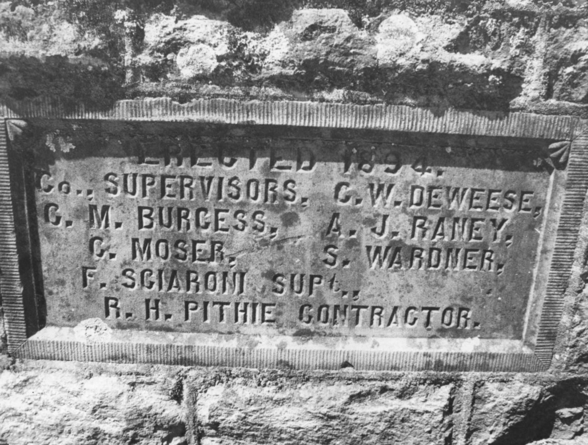
The Pope Street Bridge was commissioned by the Napa County Supervisors and constructed during 1894 by contractor R.H. Pithie.  The Pope Street Bridge is a 175-foot-long stone triple arch design which cost $14,500 to construct.  The dedication plaque can be seen affixed to the Pope Street Bridge in 1970 photo by Donald F. Groom.  


The Pope Street Bridge can be seen under construction during 1894 in a photo from the Napa County Engineer's Office.  


The Pope Street Bridge was added to the National Register of Historic Places on October 5, 1972.  The Pope Street Bridge can be seen in a series of 1970 photos by George F. Groom taken for the application for the structure to be added to the National Register of Historic Places.  


The Pope Street Bridge can be seen crossing the Napa River facing south from Silverado Trail in a modern view.  Despite it's age the Pope Street Bridge carries an 18-foot-wide road deck which can accommodate two standard sized vehicles passing each other.  


Comments

Popular posts from this blog

US Route 62 and US Route 180 in the Guadalupe Mountains

US Route 62/US Route 180 between El Paso, Texas and Carlsbad, New Mexico passes through the Guadalupe Mountains.  The Guadalupe Mountains comprise the highest peaks of Texas which are largely protected as part Guadalupe Mountains National Park.  The automotive highway through the Guadalupe Mountains was constructed in the late 1920s as part of Texas State Road 54.  US Route 62 was extended from Carlsbad through the Guadalupe Mountains to El Paso during 1932.  US Route 62 was joined in the Guadalupe Mountains by US Route 180 in 1943.  The Guadalupe Mountains comprise a portion of the 130 mile "No Services" zone on US Route 62/US Route 180 between El Paso-Carlsbad. Part 1; the history of US Route 62 and US Route 180 in the Guadalupe Mountains The Guadalupe Mountains lie within the states of Texas and New Mexico.  The Guadalupe Mountains essentially is a southern extension of the larger Rocky Mountains.  The Guadalupe Mountains is the highest range in Texas with the peak elevati

Paper Highways; unbuilt California State Route 100 in Santa Cruz

This edition of Paper Highways examines the unbuilt California State Route 100 in Santa Cruz. The History of Unbuilt California State Route 100 The route that became CA 100 was added to the State Inventory in 1959 as part of the Freeway & Expressway System as Legislative Route 287 .  According to CAhighways.org the initial definition of LRN 287 had it begin at LRN 5 (CA 17) and was defined over the below alignment to LRN 56 (CA 1) through downtown Santa Cruz. -  Ocean Street -  2nd Street -  Chestnut Street For context the above alignment would required tearing down a large part of the densely populated Santa Cruz.  A modern Google imagine immediately reveals how crazy an alignment following Ocean Street, 2nd Street, and Chestnut Street would have been. LRN 287 first appears on the 1960 Division of Highways State Map . In 1961 the definition of LRN 287 was generalized to; from LRN 5 via the beach area in Santa Cruz to LRN 56 west of the San Lorenzo River. 

New Mexico State Road 7 (Carlsbad Caverns Highway)

New Mexico State Road 7 is approximately a seven-mile highway in the Guadalupe Mountains of Eddy County. New Mexico State Road 7 connects US Route 62/US Route 180 at Whites City to the visitor center of Carlsbad Caverns National Park via Walnut Canyon. The so-called Carlsbad Caverns Highway to the National Park visitor center complex was constructed following the designation of the namesake National Monument in 1923. The current iteration of New Mexico State Road 7 was designated by the New Mexico State Highway Commission during June 1929. A proposal once was once floated to connect New Mexico State Road 7 to a cavern drive which would have been blasted into Big Room. Part 1; the history of New Mexico State Road 7 What are now Carlsbad Caverns was explored in the Guadalupe Mountains of Eddy County by local Jim White during 1898.  White explored the caverns via a homemade ladder and named several of the more notable rooms.  The name "Carlsbad Caverns" was derived from the