The original California State Route 6 was one of the original Sign State Routes announced during August 1934. As originally configured California State Route 6 was aligned from California State Route 3 in Santa Monica east to California State Route 39 near Fullerton. California State Route 6 was swapped to the second designation of California State Route 26 during 1937 to make way for US Route 6 to be extended into California. Beginning during the early 1940s the second California State Route 26 became a gapped route when it was bisected by US Route 101 Bypass. The second California State Route 26 is heavily tied to the development of Olympic Boulevard which wasn't complete until 1948. The gap in California State Route 26 was resolved during 1951 with the truncation of Legislative Route Number 171. California State Route 26 and Olympic Boulevard would gradually be replaced as Interstate 10 and the Santa Monica Freeway were constructed from 1957-1965.
Depicted above as the blog cover is a view on California State Route 26 on Olympic Boulevard approaching Fox Film Company studios during 1941. Below the California State Route 26 can be seen on the 1938 Division of Highways Map.

The history of California State Route 6 and the second California State Route 26
What was to become California State Route 6 was brough into the State Highway System during 1933 via the additions of Legislative Route Number 173, Legislative Route Number 166 and Legislative Route Number 171. The original definition of Legislative Route Number 173 (LRN 173) was as follows:
"LRN 60 in Santa Monica to the intersection of Ninth and Indiana Streets in Los Angeles via Tenth Street."
The original definition of LRN 166 was as follows:
"LRN 172, at the intersection of Indiana and Third Streets, in Los Angeles, to LRN 171 near Santa Fe Springs."
The original definition of LRN 171 was as follows:
"LRN 60 near Huntington Beach to LRN 2 near Whittier."
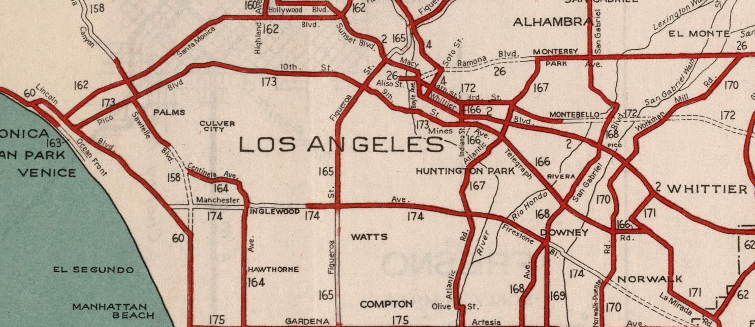
LRN 173 and LRN 166 both appear for the first time on the 1934 Division of Highways Map. LRN 173 is shown originating at LRN 60 in Santa Monica and following Pico Boulevard into Los Angeles. LRN 173 is shown following Pico Boulevard, 10th Street, 9th Street and Mines Avenue to LRN 166. LRN 166 from the eastern terminus of LRN 173 is shown following Anaheim-Telegraph Road to LRN 171 in Santa Fe Springs. LRN 171 from the eastern terminus of LRN 166 is shown following Valley View Avenue and La Mirada Road to an intersection with LRN 62 at Grand Avenue.
California State Route 6 was announced as one of the original Sign State Routes in the
August 1934 California Highways & Public Works. California State Route 6 is described as following LRN 173, LRN 166 and LRN 171 between California State Route 3/LRN 60 in Santa Monica to California State Route 39/LRN 62/LRN 171 in Fullerton.


The demise of the original California State Route 6 came when US Route 6 was extended into California on February 8, 1937, by the American Association of State Highway Officials. Given US Route 6 was duplicating the number the original California State Route 6 it would require the latter be renumbered. To accommodate US Route 6 the original California State Route 26 on LRN 183 was removed. LRN 173, LRN 166 and LRN 171 received the second designation of California State Route 26 whereas LRN 183 was left without a Sign State Route.


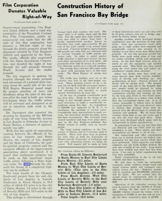
The February 1937 California Highways & Public Works announced the naming of Olympic Boulevard and provided an update on it's construction as a component of California State Route 26/LRN 173. The development of Olympic Boulevard is stated to have begun during 1922 as a local movement. Olympic Boulevard once complete would allow for a direct alignment for California State Route 26/LRN 173 to occupy between US Route 101A in Santa Monica east to LRN 166 east of downtown Los Angeles. LRN 173 is noted to have been added to the State Highway System following local level difficulties for obtaining right-of-way for the Olympic Boulevard corridor. Segments of Olympic Boulevard are shown on both ends of downtown Los Angeles as being completed. A temporary end to the Olympic Boulevard corridor at Fox Film Company studios is shown in one of the article photos.
The
July 1937 California Highways & Public Works announced the opening of California State Route 26/LRN 173 on a new segment of Olympic Boulevard between Bronson Avenue and Rimpau Avenue on July 1.

California State Route 26/LRN 173 is shown to use a temporary alignment via Pico Boulevard and Beverly Drive around the incomplete segment of Olympic Boulevard on the
1938 Division of Highways Map.
California State Route 26/LRN 173 on Olympic Boulevard at Santa Fe Avenue in Los Angeles is featured in the December 1938 California Highways & Public Works.
The
1940 Division of Highways Map displays the majority of Olympic Boulevard west of downtown Los Angeles as complete. Despite a remaining gap on Olympic Boulevard in Santa Monica, California State Route 26/LRN 173 is shown as being realigned off of Pico Boulevard.
The
January 1941 California Highways & Public Works announced the opening of two segments of California State Route 26/LRN 173 on Olympic Boulevard in Los Angeles. The first contract zone is noted to be span from Beverly Glen-Pontius Street whereas the second was Pontius Street-Bundy Drive. A two-mile segment of Olympic Boulevard from Bundy Drive west to Lincoln Boulevard in Santa Monica is noted to be incomplete. A photo of Olympic Boulevard depicts it bisecting the Fox Film Company studios.
The
1942 Division of Highways Map depicts California State Route 26 with a gap originating at the eastern terminus of LRN 173 at Indiana Street in Los Angeles. Much of what had been California State Route 26 on Anaheim-Telegraph Road (LRN 166) was designated as US Route 101 Bypass. An eastern segment of California State Route 26 is depicted as still being signed on LRN 171 east of Santa Fe Springs on Valley View Avenue and La Mirada Road. It is unclear if any continuation signage connecting the segments of California State Route 26 were still sign-posted on 9th Street or Anaheim-Telegraph Road.
1943 Legislative Chapter 964 changed the eastern terminus of LRN 173 to "LRN 166 near Downey Road" which resolved the hanging end of the highway. California State Route 26/LRN 173 is shown extended to US Route 101 Bypass/LRN 166 via 9th Street on the
1944 Division of Highways Map. The eastern segment of California State Route 26/LRN 171 is still displayed with no clear connection to the western segment.


The
January/February 1949 California Highways & Public Works featured the final segment of Olympic Boulevard to open between Bundy Drive and Lincoln Boulevard. The article stub notes the alignment of LRN 173, and Olympic Boulevard had originally been adopted by the California Highway Commission on April 3, 1936. The corridor of Olympic Boulevard from Centinela Avenue to 20th Street in Santa Monica was adopted as a freeway (expressway by modern standards) by the California Highway Commission on July 31, 1942. The final segment of Olympic Boulevard is described as having a 120-foot width and had numerous structures in addition to a railroad grade which needed to be removed/relocated. Work on the final segment of Olympic Boulevard is stated to have been completed on November 24, 1948. The final section of Olympic Boulevard provided California State Route 26/LRN 173 with a connection to US Route 101A and the western terminus of US Route 66 at Lincoln Boulevard.


California State Route 26/LRN 173 can be seen following the completed Olympic Boulevard between US Route 101A/US Route 66 and US Route 101 Bypass on the
1950 Division of Highways Map. The isolated eastern segment of California State Route 26 on LRN 171 is still shown to exist.
1951 Legislative Chapter 1562 truncated the north terminus of LRN 171 to LRN 62 near Buena Park. The truncation of LRN 171 seems to have led to the removal of the eastern segment of California State Route 26 as it no longer appears on Valley View Avenue and La Mirada Road on the
1952 Division of Highways Map.
The
March/April 1953 California Highways & Public Works references proposed Olympic-Venice Freeway and Santa Monica Freeway corridors were being considered as limited access facilities extending west from the Hollywood Freeway. The proposed freeway names were taken from the surface street corridors they were intended to be aligned generally near to.
The
January/February 1955 California Highways & Public Works notes the California Highway Commission had adopted 9.6 miles of the Olympic Freeway on May 21, 1954. The adopted portion of the Olympic Freeway is noted to be planned to span from the Santa Ana Freeway west to La Cienega Boulevard as a new alignment of California State Route 26.
The
September/October 1955 California Highways & Public Works references the California Highway Commission visiting the five southernmost counties. During the visit with the California Highway Commission the Los Angeles Chamber of Commerce made a recommendation for the proposed Olympic Freeway as a new limited-access corridor for LRN 173. The recommended corridor of the Olympic Freeway is noted to begin at the Santa Ana Freeway and end 4.4-miles at Hoover Street.
The
November/December 1955 California Highways & Public Works references structures for the planned Olympic Freeway between the Santa Ana Freeway and Harbor Freeway as being budgeted for the 1956-57 Fiscal Year. The planned Olympic Freeway is shown to be assigned to California State Route 26 and LRN 173.
The Federal Highway Aid Act of 1956 was signed into law by President Eisenhower on June 29 of said year. The Federal Highway Aid Act of 1956 provided a way for appropriations to be made towards construction of the Interstate Highway System via the Highway Trust Fund. Construction of Chargeable Interstates would be eligible for a 90% matching funding contribution. The corridor of the Olympic Freeway was added as a chargeable corridor as a component of Interstate 10.
1957 Legislative Chapter 36 changed the eastern terminus of LRN 173 from LRN 166 to LRN 2.
The
January/February 1957 California Highways & Public Works notes the California Highway Commission had adopted an alignment of the Olympic Freeway from La Cienega Boulevard west to US Route 101A/LRN 60 on November 15, 1956. A later article stub noted the Olympic Freeway had been officially named the Santa Monica Freeway.
The planned corridor of Interstate 10 and the Santa Monica Freeway west of the Santa Ana Freeway appears as part of LRN 173 on the
1958 Division of Highways Map.

The
March/April 1962 California Highways & Public Works announced the opening of the Santa Monica Freeway and Interstate 10 to the Harbor Freeway March 30th. The newly completed corridor of the Santa Monica Freeway completed an eastern bypass loop of downtown Los Angeles which was paired with the Golden State Freeway.
The new segments of the Santa Monica Freeway from the Harbor Freeway east to the Golden State Freeway are featured in a Los Angeles Area Freeway article in the
March/April 1962 California Highways & Public Works. The article references the first segment of the Santa Monica Freeway completed over the Los Angeles River to the East Los Angeles Interchange as having opened to traffic on December 4, 1961.
The completed segment of Interstate 10 and the Santa Monica Freeway east of the Harbor Freeway appears on the
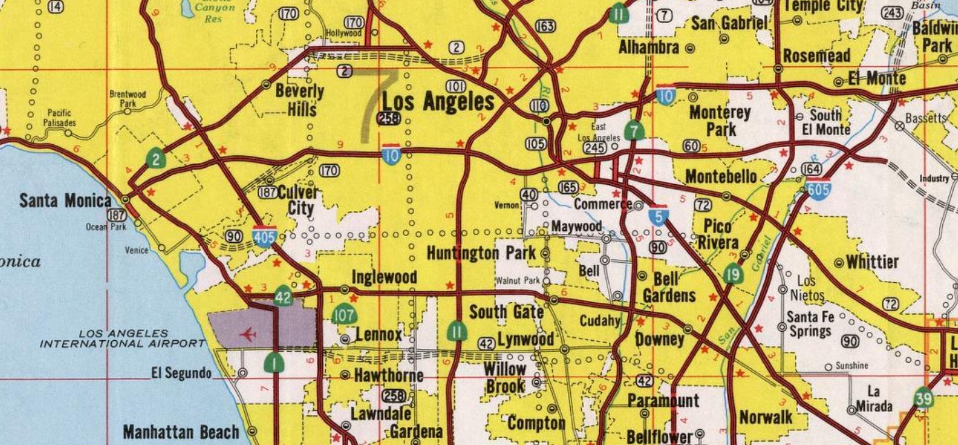
1963 Division of Highways Map. California State Route 26 is shown truncated to existing solely on Olympic Boulevard west of the Harbor Freeway.
The Legislative Route Numbers were eliminated in favor of Sign Route designations during the 1964 State Highway Renumbering. LRN 173 subsequently was assigned as a component of Interstate 10 legislatively. California State Route 26 was assigned for a third time in the Sierra Nevada Mountains east of Stockton largely over what had been California State Route 8. The second California State Route 26 remained signed west of the Harbor Freeway on Olympic Boulevard in interim as legislative spur of Interstate 10 pending completion of the Santa Monica Freeway. All these changes can be seen described on the
1964 Division of Highways Map.


The
November/December 1964 California Highways & Public Works announced Interstate 10 and the Santa Monica Freeway had been completed west to La Cienega Boulevard during November. Work is stated to be underway to complete the Santa Monica Freeway west to California State Route 1 at Lincoln Boulevard by late 1965.
Interstate 10 and the Santa Monica Freeway are shown complete to La Cienega Boulevard on the
1965 Division of Highways Map. Olympic Boulevard west of Interstate 405 is shown as an unsigned spur of Interstate 10 west to California State Route 1.
The completed Santa Monica Freeway appears on the
1967 Division of Highways Map. Olympic Boulevard is shown completely relinquished from the State Highway System.


Comments