
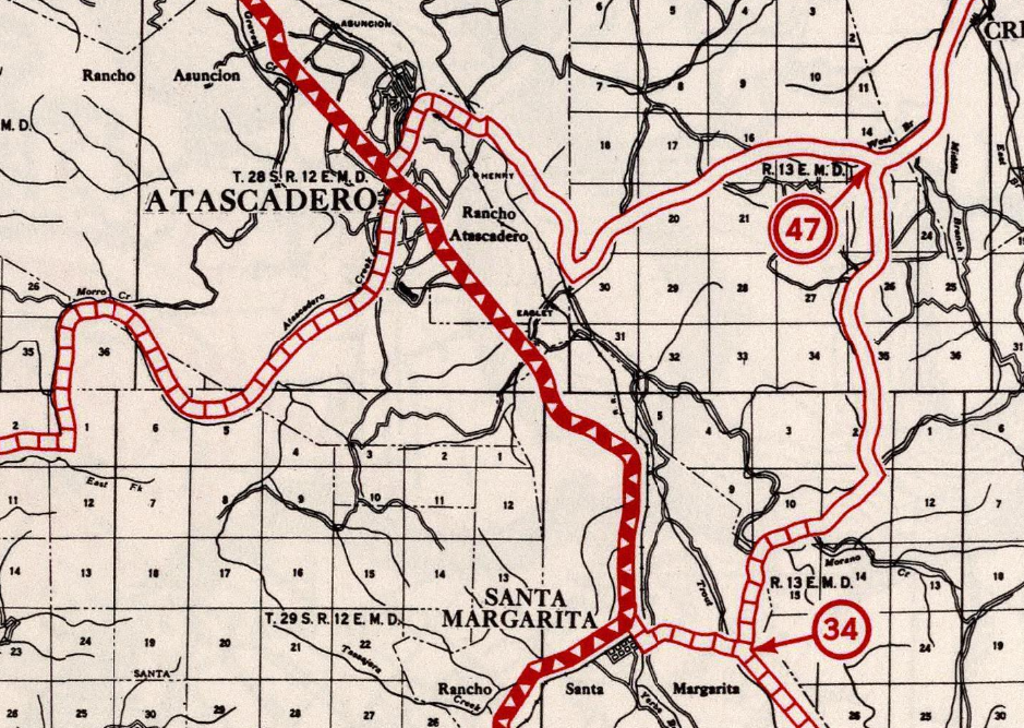
US Route 101 through Atascadero and Santa Margarita of San Luis Obispo County, California was once carried through the communities via El Camino Real. US Route 101 is depicted below on the 1935 Division of Highways Map of San Luis Obispo County when it was aligned on El Camino Real through Atascadero and Santa Margarita.
Part 1; the history of US Route 101 through Atascadero and Santa Margarita
The history of what is now Santa Margarita is tied to early Spanish Las Californias. The Salinas River watershed was largely first explored by Europeans during the second Juan Bautista De Anza Expedition of Las Californias. In time the general route of the second De Anza Expedition became the path of El Camino Real ("The Royal Road"). The route of El Camino Real was intended to solidify a path of travel between the Catholic Missions of Las Californias. Each Mission was meant to be approximately 30 miles apart from each other which would require a single day of travel by horseback. Mission San Luis Obispo de Tolosa had been established by Father Junipero Serra during September 1772 at the foot of the Cuesta Grade.
Modern Santa Margarita lies immediately north of the Cuesta Grade on land which was once the site of Spanish Santa Margarita de Cortona Asistencia. Santa Margarita de Cortona Asistencia was established in 1787 as a sub-mission to Mission San Luis Obispo de Tolosa. Santa Margarita de Cortona Asitencia was deemed necessary due to the difficulty of traversing the Cuesta Grade.
Following the advent of Mexican independence from Spain the usage of the term "El Camino Real" largely fell into disuse. Following the general secularization of the Spanish Missions in August of 1833 their land holdings were gradually split off into Ranchos. Despite El Camino Real functionally no longer existing it's path of travel remained a the favor way of traversing Alta California. In 1841 Rancho Santa Margarita was granted to Joaquin Estrada who held ownership through the Mexican-American War into the American Statehood of California.
Joaquin Estrada sold Rancho Santa Margarita in 1861 to Mary and Martin Murphy. The Murphy's were established land owners along the Salinas River watershed as they also held ownership of Rancho Atascadero and Rancho Asuncion. During early 1889 the Southern Pacific Railroad coast line had reached Rancho Santa Margarita from Templeton. Plots of land were subdivided and sold off to form the new town site of Santa Margarita. Santa Margarita served as the terminus of the Southern Pacific Railroad coast line until it was completed through the Cuesta Grade to San Luis Obispo in 1894. Santa Margarita and nearby Rancho Atascadero can be on the 1901 George F. Cram Map of California.

Rancho Atascadero and had been granted to Trifon Garcia in 1842. Atascadero was founded by east coast publisher Edward Gardner Lewis in 1913 as a planned community. The community of Atascadero was centralized around the Sunken Gardens and the Atascadero Administration Building. The Atascadero Administration Building was completed in 1918 and serves the Atascadero City Hall. Atascadero incorporated as a City July 2nd, 1979.
Rancho Atascadero and Santa Margarita were ultimately part of the American El Camino Real which began being signed as an Auto Trail starting in 1906. The era of State Highway Maintenance through Rancho Atascadeo and Santa Margarita would begin with the 1909 First State Highway Bond Act which was approved by voters in 1910. One of the highways approved through the 1909 First State Highway Bond Act was a 481.8 mile highway originating at the City Limits of San Francisco which terminated in San Diego. This highway would ultimately come to be known in time as Legislative Route Number 2 ("LRN 2"). In 1913 the Pacific Highway was plotted as a major Auto Trail which had Atascadero and Santa Margarita along it's planned route.

The 1920 Rand McNally Highway Map of California shows El Camino Real and the Pacific Highway following LRN 2 through Atascadero and Santa Margarita.

The 1924 Rand McNally Map of California shows the California Banff Bee-Line Highway co-signed with the Pacific Highway on LRN 2 through Atascadero and Santa Margarita.


The December 1929 California Highways & Public Works announced numerous upgrades to US 101/LRN 2 in San Luis Obispo County. The road surface of US 101/LRN 2 from the Southern Pacific Railroad siding of Cuesta 1.9 miles north to the outskirts Santa Margarita had been recently expanded to a 20 foot wide concrete road surface. A new 38 foot wide timber bridge is announced as being recently completed immediately north of Santa Margarita which eliminated a dangerous curve. Improvements to US 101/LRN 2 in Atascadero are stated to be underway under the supervision of a local improvement group. US 101/LRN 2 north of Atascadero 9.6 miles north to Paso Robles is stated to be in the process of being converted to a 20 foot wide concrete surface.

The October 1930 California Highways & Public Works announced the improvements to US 101/LRN 2 through Atascadero north to Paso Robles had been completed.

The October 1931 California Highways & Public Works announced US 101/LRN 2 north of Santa Margarita 9.8 miles to Atascadero was in the process of being upgraded to a 20 foot wide concrete road surface.

The February 1932 California Highways & Public Works announced the 9.8 mile surfacing of US 101/LRN 2 between Santa Margarita and Atascadero was completed.

The first documents acknowledging the existence of US 466 in California can be found during October/November 1933 in the AASHO Database. Interestingly the document from October 25th, 1933 seems to imply the AASHO assumed US 466 was intended to utilize LRN 33 from Shandon west to Paso Robles and multiplex US 101/LRN 2 to Atascadero. The December reply by the Division of Highways omits Paso Robles from the alignment of US 466 from Atascadero east to Shandon.


The Sign State Routes were announced in the August 1934 California Highways & Public Works. California State Route 178 ("CA 178") was announced as following LRN 58 west of Bakersfield to a terminus at US 101/LRN 2 in Santa Margarita.

US 466 begins to appear on commercial highway maps of California beginning in 1935. US 466 is seen on the 1935 Gousha Highway Map of California multiplexing CA 41 into Shandon and splitting southwest towards Creston on an unpaved LRN 125. US 466 can seen traversing Rocky Canyon to US 101/LRN 2 in Atascadero and terminating at CA 1 in Morro Bay.

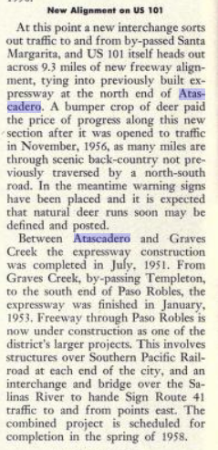
The May/June 1952 California Highways & Public Works notes US 101/LRN 2 had been converted to four lanes between Atascadero and Templeton by July 1951. This four lane segment is noted to be a component of a larger divided highway project which was planned to extend through Templeton to Paso Robles.


The new alignment of US 466 multiplexing CA 41/LRN 33 west of Shandon and US 101/LRN 2 south of Paso Robles to Atascadero is depicted on the 1959 Division of Highways Map.


Part 2; a drive on former US Route 101 on El Camino Real through Atascadero and Santa Margarita
From modern US 101 southbound approaching Atascadero traffic can reach El Camino Real via Exit 223 and crossing over the freeway eastward.


Former US 101 southbound on El Camino Real runs immediately east of the modern freeway alignment. El Camino Real southbound enters downtown Atascadero and intersects West Mall where the US 101/US 466 multiplex would have begun.


A look north on El Camino Real at the West Mall intersection; US 466 would have split from US 101 via a right hand turn.


El Camino Real leaves the City Limits of Atascadero and follows the Union Pacific Railroad southward into Santa Margarita. El Camino Real southbound picks up westbound CA 58 at Estrada Avenue approaching downtown Santa Margarita.


Comments