The corridor of US Route 27 in southern Florida serves an alternative path to reach the City of Miami over Interstate 75 and Florida's Turnpike. US Route 27 south of Interstate 4 is especially scenic as it traverses the highlands of the Lake Wales Ridge, the southern shore of Lake Okeechobee and the Everglades.

Part 1; a general history of US Route 27 south of TallahasseeAccording to usends.com US Route 27 ("US 27") was extended from Chattanooga, TN to Tallahassee, FL during 1934. US 27 can be seen with a south terminus at US 90 in Tallahassee on the 1936 Florida State Road Department Map.
On 6/10/1948 the Florida State Road Department made a formal request to the AASHO Executive Committee to extend US 27 from Tallahassee southward to Miami. The Florida State Road Department made note that US 27 would need to use a temporary routing from Leesburg south to Sebring. This temporary routing of US 27 was necessary due to numerous new planned State Road segments not yet having been completed.
The requested alignment of US 27 south of Tallassee to Miami is depicted on this map included in the 6/10/1948 letter to the AASHO.
The above map makes note that the Florida State Road Department had requested US 27 be extended to US 19 at Capps on 10/29/1947. US 27 was requested to be extended via the following Post-1945 State Roads:
- Florida State Road 20 ("FL 20") from Tallahassee east to US 19/FL 20 in Capps.
- US 19/FL 20 from Capps southeast to Perry.
- FL 20 from Perry east to US 41/FL 45 in Hot Springs.
- US 41/FL 45 south to Williston.
- FL 500 south to US 441/FL 25 in Ocala.
- US 441/FL 25/FL 500 south to Leesburg.
- FL 25 south of Leesburg to a temporary routing via FL 33.
- A temporary routing on FL 33 south to FL 567 in Polk City.
- A temporary routing on FL 567 south to US 17/FL 555 at Lake Alfred.
- A temporary routing on US 17/FL 555 south to Eagle Lake.
- A temporary routing from Eagle Lake south via what is likely Snively Avenue and Rifle Range Road to FL 60.
- A temporary routing of FL 60 east to FL 17 at Lake Wales.
- A temporary routing of FL 17 south to Sebring.
- FL 25 south to FL 80.
- FL 25/FL 80 east to South Bay.
- FL 25 south through the Everglades to US 1 in Miami
US 27 was approved by the AASHO Executive Committee to be extended from Tallahassee south to Miami on 6/23/1948. The agreement to extend US 27 was made with the understanding that the highway needed to utilize numerous temporary routes from Leesburg south to Sebring.
US 27 can be seen on the 1948 Shell Highway Map of Florida following Okeechobee Road into the City of Miami and terminating at US 1/Biscayne Boulevard via NW 36th Street.
US 27 is shown to be realigned onto a new Temporary routing from Lake Alfred to Lake Wales using the following routing on the 1951 Shell Highway Map of Florida:
- US 17 east from Lake Alfred to FL 17 in Haines City.
- FL 17 south to FL 60 in Lake Wales.
- FL 60 west to the modern alignment of US 27.
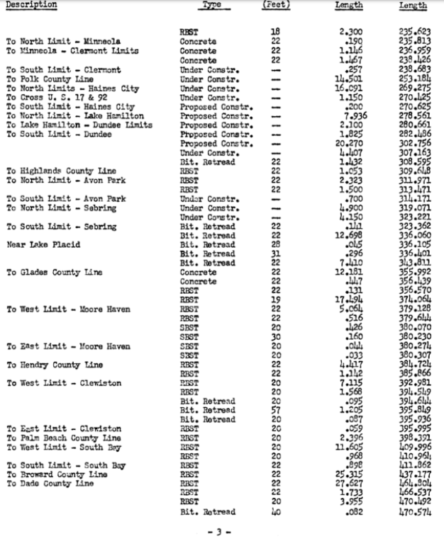
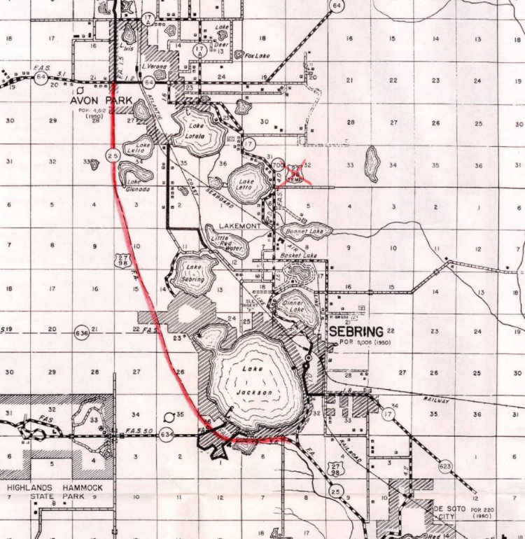
In a letter from the Florida State Road Department to the AASHO dated 5/14/1956 a request was made to reroute US 27/US 98 off of FL 17 from Avon Park south to Sebring. The Florida State Road Department letter cites a segment of FL 25 from Avon Park-Sebring as being recently completed. According to the letter the Florida State Road Department entered into an agreement dated 6/23/1948 (as seen above) with the AASHO to temporarily route US 27 along FL 17 between Avon Park-Sebring as part of the approval to extend the highway to Miami.
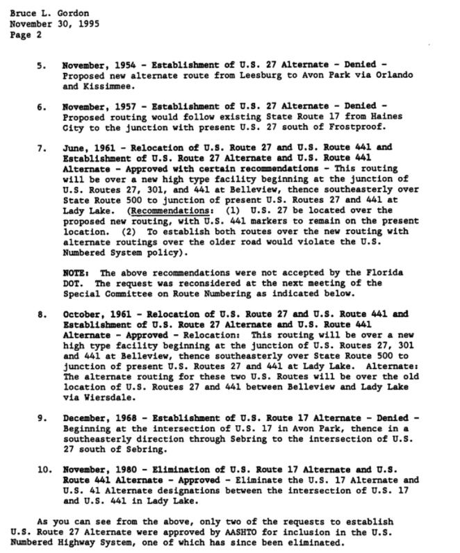
A letter dating 11/30/95 by the AASHTO to the Florida Department of Transportation reveals much of the odd history of numerous attempts by the State of Florida to establish Alternate corridors of US 27 south of Interstate 4:
- During June of 1954 the AASHO denied a request to add a US 27A segment over FL 17 from Haines City south to Frostproof.
- During November of 1954 the AASHO denied a request to add a US 27A segment originating in Leesburg. The requested US 27A segment would have traversed Orlando and Kissimmee onward to Avon Park via Frostproof.
The AASHTO does note that the United States Numbered Highway logs from; 1969, 1974, 1979 and 1989 do list a US 27A from Haines City south to Frostproof.
A Florida Department of Transportation reply to the AASHTO on 10/2/1995 notes a State Representative announced a US 27A segment from Haines City south to Frostproof in the Tampa Bay Tribune on 5/1/1958. This announcement does not appear to have ever been backed by an official AASHO approval designating US 27A from Haines City south to Frostproof.
US 27A can be seen designated from Haines City-Frostproof and Avon Park-Sebring on the
1964 Official Florida State Road Department Map on segments of FL 17.

On 9/27/1968 the Florida State Road Department made a submission to the AASHO to officially add US 27A from Avon Park to Sebring following FL 17 and FL 634. This request was denied by the AASHO on 12/1/1968 with a reason for denial noted as "insufficient justification presented."
It appears that neither the Haines City-Frostproof and Avon Park-Sebring US 27A segments were ever approved by the AASHO but were nonetheless signed. It appears that the Avon Park-Sebring US 27A segment may have only briefly been signed before reverting to being signed as FL 17. The Haines City-Frostproof US 27A segment signage appears to have been removed and reverted to FL 17 after 1995.
The alignment of mainline US 27 south of Interstate 4 has largely remained the same since the 1950s. US 27 has been expanded to a full four lane surface grade expressway in the ensuing decades south of Interstate 4. This culminated in the 1990s when US 27 south of South Bay through the Everglades was expanded to a four lane expressway.
Part 2; a drive on US Route 27 from Florida State Road 60 to Florida State Road 997
FL 60 eastbound intersects US 27 via an overpass structure in the City of Lake Wales in eastern Polk County. When I drove through in May of 2021 the FL 60/US 27 interchange was being detoured onto surface roads.
South of FL 60 the City of Sebring is signed as 35 miles away on US 27.
US 27 southbound intersects Polk County Route 17B at Hunter Brothers Road.
US 27 southbound intersects Polk County Route 640 Alturas-Babson Park Cut-Off Road.
Near Ridge Landing Airpark US 27 southbound intersects Polk County Route 630A.
At Fort Meade Road US 27 southbound picks up US 98 eastbound and intersects Polk County Route 630.


US 27 south/US 98 east intersect FL 17 at Scenic Highway.
South of FL 17 Avon Park is signed as 7 miles away on US 27/US 98.
US 27 south/US 98 east enters Highlands County and enters the City of Avon Park at County Route 17A.
US 27 south/US 98 east intersect the south segment of FL 17 and FL 64 at Main Street in Avon Park. Avon Park was founded in 1886 as a small community then known as "Lake Forest." Lake Forest would in time come to be known as Avon Park and the community would incorporate as a City on New Years Day 1926.
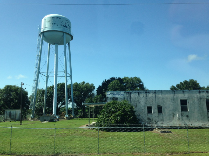
US 27 south/US 98 east enter the City of Sebring and intersect Highlands County Route 634 at Sebring Parkway.
US 27 south/US 98 east follow the western shore of Lake Jackson to the western segment of Highlands County Route 634 at Hammock Road.


Highlands County Route 634/Hammock Road access Highlands Hammock State Park. Highlands Hammock was established as a park in 1931 and predates the Florida State Park System. When the Florida State Park System was established in 1935 Highlands Hammock was included as one of the first parks. There was an early movement in the 1930s to get Highlands Hammock absorbed by the National Park Service which ultimately failed. Highlands Hammock is noted for it's cypress swamps and old growth oak trees.


US 27 south/US 98 east skirt the southern shore of Lake Jackson and intersect FL 17 at Lakeview Drive. FL 17 and Lakeview Drive serve as access to the historic district of downtown Sebring. Sebring is the Highlands County Seat and is most famous for the 12 Hours of Sebring endurance race held annually at Sebring International Raceway. Sebring was settled in 1912 around a circular plot which is now Circle Park on FL 17. Sebring would incorporate as a City during 1913 and would be selected as the first Highlands County Seat in 1921.
US 27 south/US 98 east intersects Highlands County Route 17A at Highlands Avenue.
US 27/US 98 depart Sebring southward. Near Red Beach Lake US 98 departs eastward at the the westbound junction with FL 66.
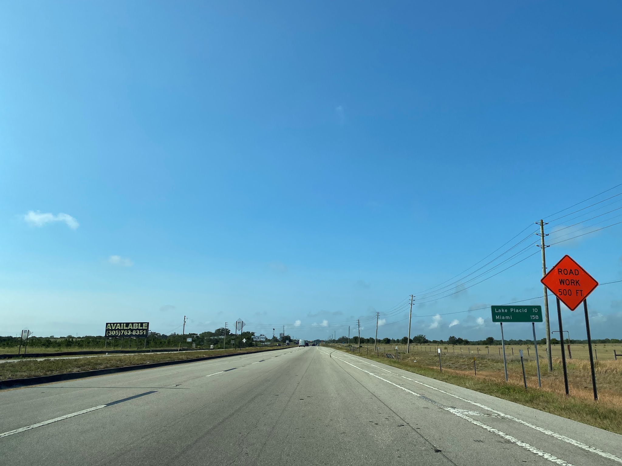
US 27 south of FL 66/US 98 is signed as 10 miles from Lake Placid and 158 miles from Miami.
Near the outskirts of Lake Placid US 27 southbound intersects Highlands County Route 17.
Near the northern City Limit of Lake Placid southbound US 27 intersects another segment of Highlands County Route 17.
US 27 enters the City of Lake Placid and crosses under the Seaboard Coast Line Railroad.
As US 27 southbound approaches downtown Lake Placid the Lake Placid Tower can be seen. The Lake Placid Tower was completed in 1960 and is 240 feet in height. The Lake Placid Tower being located along the southern flank of the Lake Wales Ridge is stated to be 392 feet above sea level.
US 27 enters downtown Lake Placid and intersects Highlands County Route 621 at Interlake Boulevard. Lake Placid was plotted out as Lake Sterns during December 1925. The community would soon change it's name to Lake Placid and incorporate as a City during July 1927.
US 27 southbound intersects Highlands County Route 17 departing Lake Placid at Main Avenue.
US 27 south of Lake Placid intersects FL 70.
US 27 south of FL 70 is signed as 36 miles from Moore Haven and 52 miles from Clewiston.
Black Bear advisories can be found on US 27 in southern Highlands County.
A rare FL 25 shield could be seen posted in a construction zone on US 27 south of Lake Placid.
US 27 southbound passes through the community of Venus and intersects Highlands County Route 731. Venus was a small siding community of the Atlantic Coast Line Railroad which was located on Highlands County Route 731. The community of Venus relocated to US 27/FL 25 when it was being constructed as a replacement for pre-1945 Old State Road 8.
US 27 southbound enters Glades County and intersects Glades County Route 17 at Dairy Road.
US 27 southbound enters Palmdale and intersects Glades County Route 733 at 3rd Street.
Palmdale is a small community which was set up by the Palmdale Land Company in 1911. The Palmdale Land Company was an operating unit of the Florida Fruit Farm which sought to develop an agriculture around Fish Eating Creek. Palmdale developed a siding facility to the Atlantic Coast Line Railroad but was otherwise relatively isolated until the development of US 27.
US 27 southbound crosses Fish Eating Creek and intersects FL 29 near the former Atlantic Coast Line Railroad switch of Harrisburg.
US 27 south of FL 29 is signed as 16 miles from Moore Haven and 32 miles from Clewiston.
US 27 crosses over a wide rail overpass south of FL 29.
US 27 southbound picks up FL 78 eastbound approaching Moore Haven. US 27 immediately south the FL 78 junction is signed as 6 miles from Moore Haven and 110 miles from Miami.
A Florida Highway Patrol Dodge Challenger pursuit car I noticed on US 27/FL 78. Too bad I didn't notice the officer was trying to show off the light bar otherwise I would have taken a closer photo.
Approaching Moore Haven FL 78 eastbound departs from US 27 southbound.
US 27 southbound passes through Moore Haven and crosses a large bridge over Caloosahatchee River. Moore Haven is located on the southwest shore of Lake Okeechobee and is the Glades County Seat. Moore Haven is mostly known for electing the first female mayor in Florida (Marian Newhall Hortwitz) in 1917. Moore Haven was significantly impacted by the 1926 Great Miami Hurricane and the 1928 Lake Okeechobee Hurricane (more to come said topic).
Prior to the modern bridge being constructed US 27 crossed the Caloosahatchee River via a draw span. Said draw span been had been constructed during 1955 amid the heyday of expansion of US 27 south of Tallahassee. The
1955 Caloosahatchee Drawbridge can be seen in this photo courtesy of bridgehunter.com.
Access to the Lake Okeechobee Scenic Trail can be found as US 27 intersects River Road.
US 27 south of Moore Haven intersects Glades County Route 720.
US 27 southbound enters Hendry County and intersects FL 80 via an interchange structure. US 27 southbound picks up a multiplex of FL 80 eastbound upon crossing under the interchange.
US 27 south/FL 80 east pass by a weigh station and then intersect Hendry County Route 720.
US 27/FL 80 cross over a canal and rail overpass upon entering the City of Clewiston.
Clewiston traces it's origins back to 1920 when John O'Brien and Alonzo Clewiston purchased a tract of land to develop a siding for a new connecting line of Atlantic Coast Line Railroad. Clewiston quickly developed around an industry based in sugar cane cropping and incorporated as a City during 1925. Much like Moore Haven the City of Clewiston was impacted heavily by the 1926 Great Miami Hurricane and 1928 Lake Okeechobee Hurricane. Clewiston today is heavily tied to the decline of the U.S. Sugar Corporation which was purchased by the State of Florida in 2008.
US 27/FL 80 cross through downtown Clewiston facing eastward. Departing the City of Clewiston US 27/FL 80 is signed as 15 miles from South Bay. East of Clewiston US 27/FL 80 intersect an older alignment at Old State Road 80.
At Evercane Road US 27 south/FL 80 east intersect Hendry County Route 835.
US 27 south/FL 80 east follows the southern shore of Lake Okeechobee into Palm Beach County. Lake Okeechobee is not visible from US 27/FL 80 due to the large earthen dike which surrounds much of it.
The 1928 Lake Okeechobee Hurricane was the second most deadly in U.S. history behind the 1900 Galviston Hurricane. The Category 5 Hurricane first hit Puerto Rico before moving to Florida with winds sustained at 160 MPH. The path of the hurricane took it directly over Lake Okeechobee which is the largest lake in Florida and headwaters of the Everglades. The Lake Okeechobee Hurricane raised the water level by at least 20 feet and wiped out many of the surrounding communities.
In total it is estimated that there was at least 2,500 fatalities related to the Lake Okeechobee Hurricane in Florida. A general list of the communities destroyed by the Lake Okeechobee Hurricane include; Port Mayaca, Sand Cut, Canal Point, Pahokee, Belle Glade, South Bay, Okeelanta, Bean City, Ritta Island, Lake Harbor, Chosen, and Kreamer Island. Some communities like South Bay and Belle Glade eventually were rebuilt but others became ghost towns largely wiped clean.
In response to the Lake Okeechobee Hurricane the Herbert Hoover Dike was built around the lake to a modern height of approximately 20 feet. The Dike was eventually expanded to almost completely encircle the lake which allowed only shipping to occur via flood control locks. Most of the communities destroyed by the Lake Okeechobee Hurricane were in the sugar fields on the south side of the lake in Palm Beach County in the Everglades watershed.
US 27/FL 80 enter the community of Lake Harbor where John Stretch Park can be found.
Old US 27 can be found immediately south of the modern highway by taking Miami Canal Road into Lake Harbor. Old US 27 is also known as "Corkscrew Road" along much of the southern shore of Lake Okeechobee in Palm Beach County.
Some scenes from John Stretch Park. Ritta Island can be seen from John Stretch Park facing north from the Herbert Hoover Dike towards Lake Okeechobee. Ritta Island first began to host settlers beginning in 1909 and was opened to homesteading in 1917 following Federal Government surveys. Ritta Island never hosted a town and the farms that occupied were eventually wiped out by the 1928 Lake Okeechobee Hurricane.
The site of Bean City is accessible via Old US 27/Corkscrew Road east of Lake Harbor. Bean City originally developed in 1923 and was partially rebuilt following the 1928 Lake Okeechobee Hurricane. Bean City once had it's own Post Office Service and even a school board approaching the onset of World War II. Bean City School closed in 1952 and the community lost it's Post Office in 1973.

US 27/FL 80 enter the City of South Bay where the latter departs towards Belle Glade via Main Street. Following the 1928 Lake Okeechobee Hurricane the community of South Bay was rebuilt and would incorporate as a City during 1941.
US 27 south of South Bay enters the Everglades alongside North New River Canal. The ruins of Gator Land can be found alongside US 27 departing South Bay.
North New River Canal is a heavy modification of the north fork of the New River. Construction of the North Fork New River Canal began in 1906 and was completed by 1912. The North Fork New River Canal can be seen on a
1917 Rand McNally Map of Florida flowing south from Lake Okeechobee towards Broward County.

The North Fork New River Canal would form the basis upon for what is now US 27 from South Bay through the Everglades towards Interstate 75/Alligator Alley. Modern US 27 between South Bay/Interstate 75 essentially is nothing more than a levee road of the North Fork New River Canal which expanded to an expressway during the 1990s. Pre-1945 FL 26 can be seen partially complete through the Everglades south of South Bay following the North Fork New River Canal on the
1939 Rand McNally Map of Florida. Notably a spur of Pre-1945 FL 26 terminating at Pre-1945 FL 149 near Davie can be seen completed following the North Fork New River Canal towards the Atlantic Ocean. This spur Pre-1945 FL 26 follows modern FL 84 and Interstate 75 east of the Andytown Interchange.

US 27 south of South Bay intersects Palm Beach County Route 827 at Boles Canal Road. The site of Okeelanta was located approximately at the junction of US 27 and Palm Beach County Route 827. At it's peak by 1920 Okeelanta had an approximate population of 200. A rebuilding attempt in Okeelanta was attempted following the 1928 Lake Okeechobee Hurricane but ultimately failed due to a lack of investors. A sugar refining facility located west of US 27 and the Okeelanta town site still bears the name of the community.
US 27 south of Palm Beach County Route 827 enters Broward County and traverses the Everglades southward to Interstate 75/FL 84 at the Andytown Interchange. US 27 southbound departs the North New River Canal at the Andytown Interchange. Andytown was a small community which developed at the intersection of US 27 and FL 84 after World War II. Andytown was demolished in 1979 to make way for the expansion of Alligator Alley (then FL 84).
US 27 southbound skirts the western boundaries of Weston and intersects Broward County Route 818 at Griffin Road. Westbound Griffin Road is signed as access to Everglades Holiday Park.
US 27 southbound passes through the western outskirts of Southwest Ranches and intersects FL 822 at Sheridan Street.
US 27 southbound passes through Pembroke Pines and intersects FL 820 at Pines Boulevard.
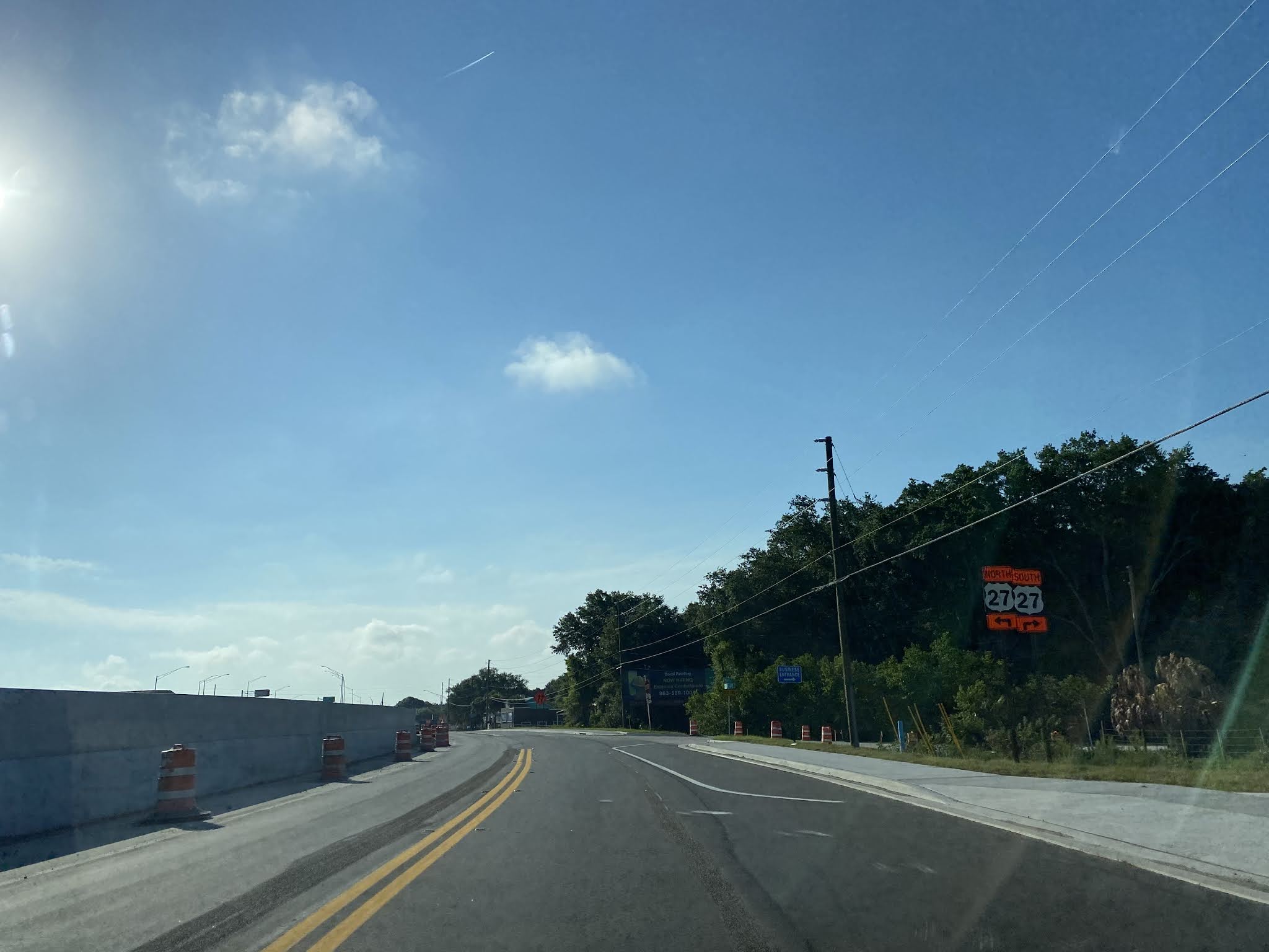
US 27 southbound enters Miami-Dade County and intersects FL 997 at Krome Avenue. Notably from 1945 to 1983 Krome Avenue was signed FL 27 which apparently to led to much confusion for travelers on US 27. From FL 997 the alignment of US 27 jogs southeast towards Florida's Turnpike on Okeechobee Road and then east on NW 36th Street into downtown Miami.


Comments