
This past weekend I was visiting the City of Sacramento for a wedding. That being the case I decided to head out on a morning run through Old Sacramento, Jibboom Street Bridge, I Street Bridge, Tower Bridge, and path of US Route 40/US Route 99W towards the California State Capitol. My goal was to retrace the paths of the various highways that once traversed the Old Sacramento area.
This blog is part of the larger Gribblenation US Route 99 Page. For more information pertaining to the other various segments of US Route 99 and it's three-digit child routes check out the link the below.

The old highway alignments of Sacramento
The City of Sacramento lies at the confluence of the Sacramento River and American River in Sacramento Valley. Sacramento Valley was discovered by Spanish Explorer Gabriel Moraga in 1808. Moraga referred to the fertile Sacramento Valley akin to a "Blessed Sacrament." By 1839 John Sutter Sr. settled in Mexican held Sacramento Valley. Sutter Sr. founded Sutter's Fort in 1840 and a community known as New Helvetia around it. By January of 1848 gold was discovered at Sutter's Mill to the east on the American River in Coloma which spurred the 1849 California Gold Rush.
In August of 1848 John Sutter Jr. arrived in New Helvetia to assist his father in the growing community. By December of 1848 Sutter Jr. along with Sam Brannan plotted out the City of Sacramento. The street grid of Sacramento was laid out with lettered streets being east/west ascending alphabetically southward with north/south streets being numbered ascending eastward from the Sacramento River. The City of Sacramento adopted a City Charter and incorporated in 1850. In 1854 Sacramento was declared the State Capitol, although it wouldn't be declared the permanent Capitol until 1879.
Sacramento was strategically located at an important junction point on the Sacramento River which made it easy to access the Pacific Ocean via the Sacramento River Delta and San Francisco Bay. From 1859 to 1861 the City of Sacramento was the western terminus of the Pony Express mail route. Construction of the First Trans Continental Railroad began in Sacramento by the Central Pacific Railroad and would become the western terminus of the line when it was completed in 1869.
The street level of Sacramento was heavily altered following a major flood in 1861. Subsequently the street level of downtown Sacramento was raised from 1862 to 1870 which covered the first story of most of the existing buildings. The downtown area raised after the 1861 flooding gradually became what now known today as Old Sacramento. Old Sacramento is roughly bounded by the; Sacramento River, Capitol Mall (formerly M Street), Interstate 5, and I Street.
This 1873 map of the street grid of the City of Sacramento shows how the city was following the completion of the First Transcontinental Railroad. I marked the location of the future Jibboom Street Bridge, 1911 I Street Bridge, Tower Bridge, and where the original confluence of the Sacramento River and American River was located before the city was raised. The only bridge present in 1873 was the original 1867 I Street Bridge which was a wooden rail structure.

Sacramento was a focal point of the early adopted California State Highways. The earliest State Highways in Sacramento were Legislative Routes Numbers 3, 4, 6, and 11. Although I refer to the LRNs by numbers they were not actually assigned such designations until the 1915 Second State Highway Bond Act.
The first State Highway to reach Sacramento was an extension of the Lake Tahoe Wagon Road which eventually became LRN 11. The route of LRN 11 was first defined in 1895 as running from Placerville east to the Nevada State Line via the Lake Tahoe Wagon Road. A new section of what would become LRN 11 was added as a State Highway between Sacramento and Folsom in 1897. The remaining segment of LRN 11 between Folsom to Placerville was added to the State Highway system as part of the 1909 First State Highway Bond Act. LRN 11 eventually became part of the South Route of the Lincoln Highway in 1913, the Victory Highway south of Sacramento in 1921, and US Route 50 east from Sacramento in 1926.
LRN 3 was part of the 1909 First State Highway Bond Act and ran from downtown Sacramento north over the American River towards Oregon. The path of LRN 3 in Sacramento eventually became part of the North Route of the Lincoln Highway in 1913 which arrived at the State Capitol via 12th Street. LRN 3 between Sacramento and Roseville eventually became part of US Route 40 and US Route 99E in 1926.
LRN 4 was part of the 1909 First State Highway Bond Act and ran south out of Sacramento to Los Angeles. In 1913 LRN 4 became part of the original alignment of the Lincoln Highway south of Sacramento and the 1920 alignment of the National Park-to-Park Highway. In 1926 LRN 4 became part of US Route 99.
LRN 6 was part of the 1909 First State Highway Bond Act and ran west from downtown Sacramento over the Sacramento River to Woodland. LRN 6 may have first used the 1867 I Street Bridge when adopted but it is unclear. The path of LRN 6 eventually crossed the M Street Bridge over the Sacramento River when said structure was completed in 1911. LRN 6 west out of Sacramento eventually became part of US Route 40/US Route 99W in 1926 and part of the realigned 1927 path of the Lincoln Highway.
More information about the history of the early LRNs can be found on CAhighways.org.
Chronology of California Highways Chapter 1; A Highway System is Established 1897-1914
This 1930 map below illustrates what was likely the original alignment of US 40, US 50, US 99, US 99E, and US 99W in Sacramento.

Heading westbound US 40 likely used the following path:
- 16th Street over the American River to L Street. There is a possibility that US 40 used the early 12th Street alignment of the North Lincoln Highway.
- L Street to 9th Street at the State Capitol.
- 9th Street to M Street.
- M Street west over the Sacramento on the M Street Bridge.
Heading westbound US 50 likely used the following path:
- Folsom Boulevard to Alhambra Boulevard.
- Alhambra Boulevard to L Street.
- L Street either to 16th Street, 12th Street, or even the State Capitol. Oddly the original 1926-1932 western terminus of US 50 seems to have been lost to time. Even USends.com isn't certain the 1926-1932 western terminus of US 50.
USends.com on US 50 endpoints
Heading northbound US 99 likely used the following path:
- Stockton Boulevard to Alhambra Boulevard.
- Alhambra Boulevard to L Street.
- L Street to either 16th Street or 12th Street where US 99E and US 99W would have split. US 99E would have used either 16th Street or possibly 12th Street. US 99W continued west on L Street to 9th Street, 9th Street to M Street, and M Street west over the Sacramento River.
By 1931 the Jibboom Street Bridge was built over the American River near the confluence with the Sacramento River. In 1934 the Signed State Highways were created to supplement the US Routes in California. CA 16 and CA 24 were routed through Sacramento which multiplexed over the I Street Bridge. In 1935 the I Street Bridge was obtained by the Division of Highways as an extension of LRN 50. The Tower Bridge also replaced the M Street Bridge also in 1935.
This 1938 State Highway Map of Sacramento shows with greater clarity the path of the State maintained highways through downtown Sacramento.

The path of US 40 westbound on the above 1938 Map of Sacramento is as follows:
- 16th Street over the American River to L Street.
- L Street to 5th Street.
- 5th Street to M Street.
- M Street west over the Sacramento River.
US 50 was extended to the San Francisco Bay Area in 1932 and followed US 99 south on Alhambra Boulevard and Stockton Boulevard.
US 99 had a clear split at 16th Street into US 99E and US 99W. US 99W followed US 40 west out of Sacramento and US 99E followed US 40 east out of the city.
CA 16 eastbound took the following path through Sacramento:
- I Street Bridge over the Sacramento River to 5th Street.
- 5th Street to Alhambra Boulevard.
- Alhambra Boulevard Folsom Boulevard.
CA 24 northbound took the following path through Sacramento:
- Freeport Boulevard to Y Street.
- Y Street to 16th Street.
- 16th Street to L Street.
- L Street to 5th Street.
- 5th Street to I Street.
- The I Street Bridge over the Sacramento River.
The map below shows the changes to the State Highways in Sacramento in 1940.

The following changes to the State Highways can be noted on the above 1940 map of Sacramento:
- CA 24 was moved a new alignment on 5th Street to Broadway. Broadway was previously designated as Y Street.
- US 40/99W and CA 16 were shifted onto N Street around the Capitol via 15th Street.
- A US 50 Bypass Route of Sacramento was built on LRN 98 over 65th Street at Folsom Boulevard and 14th Avenue to Stockton Boulevard.
- M Street appears to have been re-designated as Capitol Avenue. I'm to understand that west of the Capitol the designation became Capitol Mall in the 1960s.
The 1942 Map of Sacramento below shows US 40/99W and CA 16 shifted back onto 9th Street to reach Capitol Mall.


The 1948 Map of Sacramento shows the US 40/99E bypass of North Sacramento complete.

The 1951 Map of Sacramento shows a planned US 40/99W bypass route of West Sacramento and a new planned routing of US 99E east of Sacramento.

The 1955 Map of Sacramento shows significant changes to the highways through the city. The US 40/99E bypass of West Sacramento is shown completed. US 40/99E are show split onto one-way alignments. US 40 East and US 99E North are shown exiting downtown Sacramento on 16th Street. US 40 West and US 99E South are shown on 12th Street, F Street, and 15th Street. The full planned bypass route of US 99E east of Sacramento and a new route of US 99 are shown.

The 1956 Map of Sacramento shows a new routing of US 99E along 30th Street northbound and 29th Street southbound from Capitol Avenue. US 50 and US 99 split south out of Sacramento on 29th/30th Street to Broadway where they continue to Stockton Boulevard. A new planned freeway alignment for US 50 and US 99 south of Sacramento is shown. The US 50 Bypass Route is shown as being eliminated.

The 1958 Map of Sacramento shows the new route of LRN 232 over the Jibboom Street Bridge. LRN 232 was first approved as LRN 207 in 1949 but was renumbered in 1951. CA 24 and CA 16 were shifted onto one-way traffic patterns on 3rd Street and 5th Street.

The 1960 Map of Sacramento shows the planned route of I-5 as LRN 238 and the planned route of I-880 as LRN 242.

The 1963 Map of Sacramento shows a split route of US 40/99W and CA 16 from Capitol along 7th Street and 9th Street. The planned route of I-80 appears south of downtown Sacramento.

In 1964 the California State Highway renumbering occurred. The following changes appear on the 1964 Map of Sacramento:
- The route of CA 24 south of Sacramento was renumbered to CA 160.
- US 40/99E east of the American River were assigned LRN 80 denoting it would be part of the future path of I-80.
- CA 24 on 3rd Street, 5th Street, and Broadway was assigned LRN 16.
- US 40 and US 99W were assigned LRN 80.
- US 40 north of downtown Sacramento was assigned LRN 160.
- CA 24 over the Jibboom Street Bridge was assigned LRN 99.
- LRN 238 was reassigned as LRN 5.
- LRN 242 was reassigned as LRN 880.

The 1965 Map of Sacramento showed more changes to the highway system in the city:
- I-80 was co-signed over US 99E. I-80 was built to freeway standards south of the American River.
- CA 160 was co-signed with US 40 north over the American River.
- CA 70/CA 99 were signed over the former route of CA 24 over the Jibboom Street Bridge. Oddly CA 99 existed alongside US 99, US 99E, and US 99W in 1965.
- I-80 was co-signed over US 40/99W west out of Sacramento.
- US 40/CA 16 were moved onto a new alignment on P Street and Q Street.

The 1967 Map of Sacramento shows changes which simplified the highway system in the city:
- US 40, US 99, US 99E, and US 99W were all eliminated from California.
- The implied temporary path of the unfinished I-80 appears to have been on Broadway.
- A gap in CA 16 appears to have been created through Sacramento.

The 1969 Map of Sacramento shows the following changes to the highway system in the city:
- CA 99/CA 70 were moved onto the new alignment of I-5 north over the American River. The Jibboom Street Bridge was removed from the State Highway system.
- CA 275 was assigned to former US 40/99W from I-80 over the Sacramento River to the State Capitol. CA 275 was legislatively approved by 1967.

The 1970 Map of Sacramento shows the following changes to the highway system in the city:
- I-80 was completed through Sacramento. I-80 would eventually be moved to the future I-880 alignment north of the American River. The former route through downtown would become the I-80 Business Loop, unsigned CA 51 and part of US 50. More on the I-80 Business Loop/CA 51 can be found in a previous blog post I wrote:
- I-5 is shown complete the I Street Bridge and possibly CA 275. A temporary alignment appears on 3rd Street and 5th Street.

According to USends by 1972 US 50 was truncated back to Sacramento at I-80 east of downtown. The 1975 Map of Sacramento shows I-5 complete.

The 1982 Map of Sacramento shows CA 16 truncated out of Sacramento and the I Street Bridge no longer part of the State Highway system. CA 84 was assigned to some former parts of CA 16 west of the Sacramento River.

The 2005 Map of Sacramento shows various changes which occurred in the recent decades to highways in the city:
- According to CAhighways.org CA 275 was legislatively deleted in 1996. The definition was reactivated by the legislature in in 2010 over the Tower Bridge which made it the smallest State Highway by length. The route of CA 275 west of the Sacramento River underwent a road diet to convert it from a freeway to a parkway. The AAroads main page contains an article showing how the CA 275 freeway appeared before it underwent the current conversion to a parkway.
- According to CAhighways.org CA 160 on surface streets in Sacramento was relinquished to the city in 2002.
- According to Cahighways.org CA 84 in the city limits of Sacramento was relinquished in 2003 with the stipulation the route remained signed.

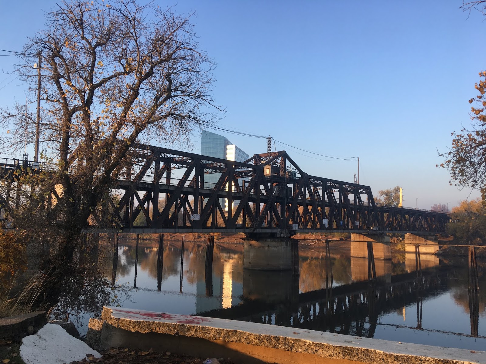
With all the above highway history dispensed of above time for some actual photos. My run through much of the old surface highway alignments in Sacramento started at the Jibboom Street Bridge. As stated above the Jibboom Street Bridge became part of CA 24 but opened in 1931 under Sacramento County maintenance.


The confluence of the American River and Sacramento River can be seen from the Jibboom Street Bridge.

My personal opinion is that the Jibboom Street Bridge is best viewed from the American River. The green paint on the Jibboom Street Bridge makes the structure pop in the background of a foggy winter morning. The Jibboom Street Bridge is a truss design with a swing span which has not been used since 1936. The Jibboom Street Bridge is 959 feet in length over the American River. The Jibboom Street Bridge closed for repairs in early 2018 but reopened several months later.

I continued my run south on the Sacramento River Bike Trail. Along the path there are various interesting older structures along the river such as the older Pacific Gas & Electricity Company building below.


Oddly the Sacramento River Bike Trail has call boxes which were possibly sourced by Caltrans. Jibboom Street and I-5/CA 99 run alongside the Sacramento River Bike Trail north of Old Sacramento.

Jibboom Street and former CA 24 rises on a viaduct structure over the Sacramento River Bike Trail.

Beneath the Jibboom Street Viaduct the Sacramento Railyards of the Southern Pacific Railroad can be seen. The Sacramento Railyards date back to the completion of the Sacramento Valley Railroad in 1856 and was later acquired by the Central Pacific Railroad during the construction of the First Transcontinental Railroad. As stated above the First Transcontinental Railroad was completed by 1869. The Central Pacific was absorbed by the Southern Pacific Railroad in 1870 who continued to use the Sacramento Railyards through much of the 20th Century. In 1996 the Southern Pacific was acquired by the Union Pacific Railroad. The Sacramento Railyards largely were disused by the early 21st Century and little has happened with the structures since.
The fog over the Railyards was a little too thick in 2018 to get a clear photo but I did obtain one in 2016.


The I Street Bridge as stated above was completed in 1911 over the Sacramento River. The top deck of the structure carries traffic from Jibboom Street and I Street to the top level road deck. The bottom deck of the I Street Bridge carries rail traffic. Both CA 16 and CA 24 both used the I Street Bridge before the latter was realigned over the Jibboom Street Bridge. The Southern Pacific constructed the underpass used by the Sacramento River Bike Trail circa 1913-1914.


Road traffic is slated to be moved off the I Street Bridge to a new structure which will be located to the north at Railyards Boulevard. The Jibboom Street Viaduct and I Street Viaduct are slated to be demolished as part of the new bridge project. Construction on the Railyards Boulevard Bridge is slated to begin 2021.
Upon entering Old Sacramento there is a branch from the Sacramento River Bike Trail which descends down the river retaining wall. This area of Old Sacramento offers the best view of the evidence of the City streets being raised above the flood plain in the 1860s.

Old Sacramento is roughly bounded by Front Street, I Street, 2nd Street, and L Street. Old Sacramento was restored in the 1960s during the construction of I-5 and added to the National Register of Historic Places in 1966. Today Old Sacramento is a State Historic Park but many of the structures are still active as businesses.

One of the primary attractions in Old Sacramento is the California State Railroad Museum. The first attraction opened to the public back in 1976 was the Central Pacific Rail Road Depot. The Central Pacific Rail Road Depot displays various locomotives and cars along the track line.


At the corner of Front Street and I Street the California State Railroad Museum has a roundhouse locomotive turn table on display. The I Street Bridge can be seen in the background.

Also located at the corner of Front Street and I Street is the Big Four House. The Big Four House was originally several individual buildings that were constructed during 1851 and 1852. The Big Four House is mostly associated with the original investors of the Central Pacific Railroad which operated the line from the second floor of the structures. During 1878 ownership of the Central Pacific was consolidated and the Big Four House was renovated into a single building.

A look progressing southward on Front Street from I Street at the Big Four House towards L Street.


The Eagle Theatre is located at 925 Front Street and dates back to 1849. The Eagle Theatre survived a flood in 1850 and has been preserved as a display piece.


Located just off of Front Street on the Sacramento River is the Delta King steamwheel steam ship. The Delta King is identical to another ship known as the Delta Queen and was completed in 1927. The Delta King was assembled in Stockton starting 1924. The Delta King was used as a 10 hour service linet between San Francisco and Sacramento but also made scenic tours of the San Joaquin River to Stockton. The Delta King was used during World War II as a Naval Reservist transport ship and a ferry. After World War II the Delta King was towed to British Columbia to serve as company housing for the workers Kennedy Dam. The Delta King was eventually restored and returned to Sacramento in the 1980s. The Delta King is 285 feet long and it's steam engine produces a peak 2,000 Horse Power.

The southwest corner of 2nd Street and J Street served as the western terminus of the Pony Express at the B.F. Hastings Bank Building (first photo on the left). The Pony Express operated from St. Joseph Station in Missouri west towards Sacramento from 1860 to 1861. In addition to the Pony Express terminal the B.F. Hasting Bank Building was also the first seat of the California Supreme Court, the structure was built in 1852. There are various monuments regarding the Pony Express located at 2nd Street and J Street.


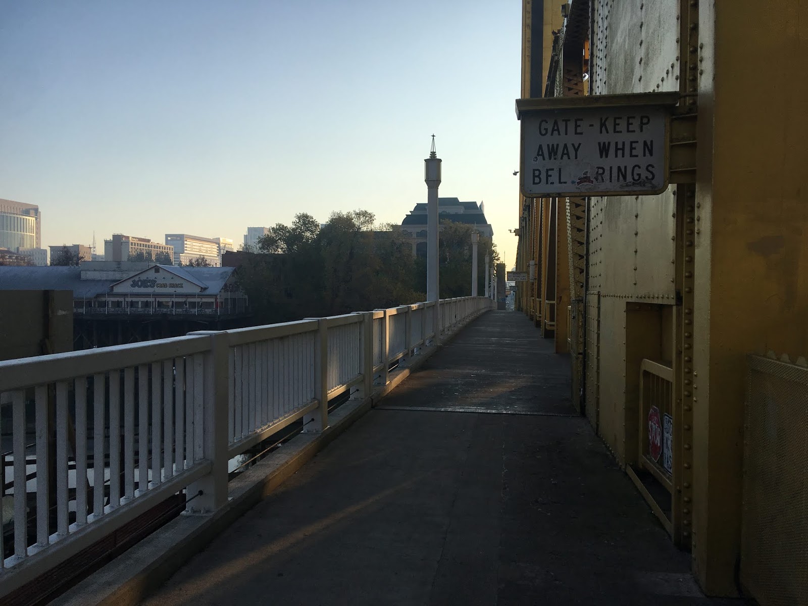
From Old Sacramento I ran to Capitol Mall and the Tower Bridge. As stated above the Tower Bridge was completed in 1935 and replaced the M Street Bridge. The Tower Bridge and CA 275 are 737 feet in length carrying four lanes of traffic over the Sacramento River. The Tower Bridge is a vertical lift design that has a 100 foot clearance above the high water mark of the Sacramento River.

Crossing Capitol Mall at the eastern foot of the Tower Bridge offers an impressive view of the road deck to the west and the State Capitol ten streets to the east. Suffice to say US 40/99W had one hell of an impressive view during it's heyday.


Running west along the eastbound of the Tower Bridge lanes offers a view south on Sacramento River towards US 50. There is various signs on the Tower Bridge alerting pedestrian traffic to get off the lift span when the bell from the control station rings.


Looking east towards the Tower Bridge it is hard to image a freeway grade that was only recently converted to a parkway.


As mentioned above AAroads has a highway guide for CA 275 which shows the freeway grade before it was converted to a parkway.
AAroads highway guide California 275
The westbound lanes of the Tower Bridge offer a northward view of the I Street Bridge.


On the south side of the Tower Bridge on the Sacramento River Bike Trail there are several historical placards detailing the history of the structure. There is a historical placard regarding the 1911 M Street Bridge


From the south side of the Tower Bridge a sign stating the operating hours for the control bridge can be observed. The Tower Bridge lift span is surprisingly operated by only two 100hp electric motors.


Looking east from the foot of the Tower Bridge on Capitol Mall the I-5 overpass and the State Capitol can be seen in the distance.

The view above I-5 is actually fairly nice despite the heavy pedestrian fencing.


Capitol Mall and 3rd Street as stated above used to serve the southbound traffic for CA 24 on a one-way configuration. 3rd Street also served as part of CA 70, CA 99, and Temporary I-5.

At 4th Street and Capitol Mall there is a button-copy BGS still directing CA 70/99 traffic northbound to 5th Street. Surprisingly the I-5 shield is mounted to a surface level pole.


5th Street used to serve as parts of US 40, US 99W, CA 16, CA 24, CA 70, CA 99, and Temporary I-5.


From 5th Street there is a centered view looking back west towards the Tower Bridge and east towards the State Capitol.


From 5th Street I turned around and headed back to my hotel. Later in the day I went all the way to the State Capitol located at Capitol Mall and 10th Street. US 40/US 99W and CA 16 for the most part would have turned at 9th Street and Capitol Mall. The California State Capitol Building was designed to resemble the U.S. Capitol Building and was under construction from 1861 to 1874.


Looking back west on from the State Capitol offers a wide vista of Capitol Mall and the Tower Bridge. The Tower Bridge was repainted to match the gold color of the State Capitol. Personally I find the view down what was once US 40/US 99W to be one of the best in the State on a surface street. About all I can think to say in closing is that Sacramento is vastly underrated in terms of scenery and infrastructure history worth seeing.

Continuing north to Red Bluff on US Route 99W?
Continuing north to Red Bluff on US Route 99E?
Continuing south on US Route 99 to Elk Grove, Galt and Lodi?
Continuing south on modern California State Route 99 to Wheeler Ridge?
Comments