
When California State Route 4 was commissioned in August 1934 it passed through the heart of Altaville and Angels Camp. The original highway alignment eastbound entered Altavilla via Stockton Road and met California State Route 49 at Main Street. Main Street carried a multiplex of California State Routes 49 and 4 south through downtown Angels Camp where the latter highway split away via Vallecito Road. California State Route 4 was ultimately shifted to the Angels Camp Bypass during July 2009 but much of the original corridor was retained as a Business Route.
The multiplex of California State Routes 4 and 49 along Main Street in Angels Camp can be seen as the cover photo sourced from the May/June 1966 California Highways & Public Works. California State Route 4 can be seen passing through Altaville and Angels Camp via Stockton Road, Main Street and Vallecito Road below on the 1947 United States Geological Survey map of San Andreas.

Part 1; the history of California State Route 4 in Angels Camp
Angels Camp was founded as a mining camp by Henry and George Angel in December 1848 along what is now Angels Creek. By the following year a community of approximately 300 had grown into a fledging town. Nearby Altaville would be founded a short distance north of Angels Camp in 1852. Both communities were the hub of significant mining activity in Calaveras County through the 1850s. Angels Camp would incorporate on January 24, 1912, and remains the only city in Calaveras County. Altaville was annexed into Angels Camp in 1972 but has a fairly distinct community history.
Prior to the State Highway service in Angels Camp the corridor that would ultimately become California State Route 4 was built as Reed's Turnpike. Said turnpike was heavily tied to the copper boom in nearby Copperopolis.
Copperopolis was founded in 1860 by William K. Reed, Dr. Allen Blatchly and Thomas McCarty. The claims at Copperopolis were the second major copper strike in Calaveras County after those found at Telegraph City. By 1862 William K. Reed sold his interests in the Union Mine and constructed the namesake Reeds Turnpike to Stockton. This roadway would remain a franchise toll road until 1865 when it became a public highway. Reeds Turnpike would later be used as a basis for much of early California State Route 4 between Stockton and Altaville (now part of Angels Camp).
Reed's Turnpike can be seen between the Stockton & Copperopolis Railroad station at Peters and Altaville on the 1882 Bancroft's map of California.

State Highway service would begin in Angels Camp with additions to Legislative Route Numbers 24, 75 and 65.
Main Street in Angels Camp was added to the State Highway System as part of Legislative Route Number 65 by way of 1921 Legislative Chapter 839. The original definition of the so-called "Golden Chain Highway" was from Auburn south through the Sierra Nevada foothills to Sonora.
Vallecito Road in Angels Camp was added to the State Highway System as part of Legislative Route Number 24 via 1924 Legislative Chapter 375. Chapter 375 closed the gap on Legislative Route Number 24 between San Andreas and Calaveras Big Trees. Stockton Road was brought into the State Highway System in 1933 when Legislative Route Number 75 was extended from Walnut Creek east to Legislative Route Number 65 in Altaville.
The August 1934 California Highways & Public Works would announce the initial run of Sign State Routes. California State Route 4 was announced as passing through Angels Camp via Stockton Road, Main Street and Vallecito Road. The segment along Main Street was multiplexed with California State Route 49.


California State Route 4 can be seen passing through Altavilla and Angels Camp via Stockton Road, Main Street and Vallecito Road below on the 1947 United States Geological Survey map of San Andreas.
The multiplex of California State Routes 4 and 49 along Main Street in Angels Camp can be seen below as it was featured in the May/June 1966 California Highways & Public Works. The hanging clothes over the highway were noted to be a form of advertising for the Jumping Frog contest.

In November 2002 the California Transportation Commission selected a two-lane expressway alignment as the then proposed bypass of Angels Camp along California State Route 4. Construction of the Angels Camp Bypass would commence in 2007 and would be open to traffic on July 21, 2009. The Angels Camp Bypass strays north through the neighborhood of Altaville and bypasses downtown Angels Camp. An overpass structure was constructed over Murphys Grade Road as a grade separation.
The Angels Camp Bypass can be seen carrying California State Route 4 north of downtown Angels Camp on the 2012 United States Geological Survey map of Angels Camp.
Much of the original alignment of California State Route 4 was retained as a Business Route. The California State Route 4 Business Route originates at the new bypass alignment in Altaville and follows Main Street through downtown Angels Camp. The Business Route loops back to the mainline via Vallecito Road. Until being relinquished in June 2017 Vallecito Road was retained as "California State Route 4S."

Part 2; a drive on California State Route 4 Business
Northbound California State Route 49 enters Angels Camp via Main Street. California State Route 49 begins a multiplex of California State Route 4 Business at Vallecito Road.
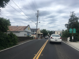

Some of the signage on the California State Route 4 Business Route is inherited from when it was the mainline highway. This signage assembly is along Main Street facing south towards Vallecito Road.


Angels Camp is largely known for the 1865 Mark Twain short story called "The Celebrated Jumping Frog of Calaveras County" which has led to the community nickname of "Frogtown."


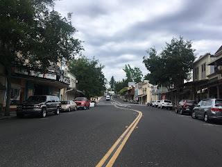
Main Street north of downtown Angels Camp passes Stockton Road and approaches the modern alignment of California State Route 4.


Some of the signage on the California State Route 4 Business Route is inherited from when it was the mainline highway. This signage assembly is along Main Street facing south towards Vallecito Road.

A California State Route 4 shield with a "Business" placard can be seen along Vallecito Road below.

Angels Camp is largely known for the 1865 Mark Twain short story called "The Celebrated Jumping Frog of Calaveras County" which has led to the community nickname of "Frogtown."


Main Street north of downtown Angels Camp passes Stockton Road and approaches the modern alignment of California State Route 4.


Comments