California State Route 78 is a 194-mile east/west State Highway located in southern California. California State Route 78 begins at Interstate 5 in Oceanside of San Diego County and terminates at Interstate 10 near Blythe of Riverside County. California State Route 78 between Interstate 5 and Interstate 15 is aligned on the Ronald Packard Parkway over the corridor traditionally known as the Anza Freeway. California State Route 78 east of Interstate 15 climbs over mountain grades into the Sonoran Desert where it become a largely rural highway. The blog cover photo above is California State Route 78 on Vista Avenue between Oceanside and Vista as seen in the 1955 California Highways & Public Works.
Part 1; the history of California State Route 78
Disclaimer; the pre-State Highway history and Glamis Road elements of this blog are sourced from newspaper references attributed to AAroads forum user rschen7754. User rschen7754 was the primary Wikipedia author for the California State Route 78 article which can be found below:
Components of what became California State Route 78 date prior to when they annexed into the State Highway System. In 1870 a gold rush in what is now known as the Banner Mining District began. A highway known as the Banner Toll Road was constructed between the towns of Julian and Banner to facilitate commerce between the two communities. By 1874 the Banner Toll Road was purchased by San Diego County and made accessible to the public. Ultimately the Banner Toll Road was realigned away from Graves Hill during the 1890s and came to be known as the Banner Grade. The Banner Toll Road can be seen on the 1882 Bancroft's Map of California and Nevada connecting Julian-Banner.
During the early 1920s the existing Julian Road and Santa Ysabel Grade were reconstructed by San Diego County from Ramona east to Julian. By 1922 an ACSC scouting team noted that the entire road between Ramona east to Julian had been paved. By 1925 San Diego County had constructed a new road from Banner east to LRN 26 near Kane Springs. The upgraded road between Ramona-Julian and the new highway from Julian to Kane Springs both appear on the 1925 California State Automobile Association Map.
CA 78 was one of the original Sign State Routes announced in the August 1934 California Highways & Public Works. CA 78 was defined as a Sign State Route originating at US Route 101/LRN 2 near Oceanside east to US Route 99/LRN 26 at Kane Springs via Ramona.
The components initially made-up CA 78 comprised of the following Legislative Route Numbers (LRNs):
- LRN 196 from US Route 101/LRN 2 near Oceanside east to US Route 395/LRN 77 in Vista. LRN 196 was added to the State Highway System as part of 1933 Legislative Chapter 767.
- LRN 197 from US Route 395/LRN 77 near Escondido east to LRN 198 in Ramona. LRN 197 was added to the State Highway System as part of 1933 Legislative Chapter 767.
- LRN 198 from LRN 197 in Ramona east to US Route 99/LRN 26 near Kane Springs. LRN 198 was added to the State Highway System as a highway aligned from Spring Valley-Kane Springs via 1933 Legislative Chapter 767.
Another future segment of CA 78 was added via 1933 Legislative Chapter 767 in the form of LRN 146 from US Route 60/LRN 64 in Blythe of Riverside County south to the Imperial County Line at Palo Verde. The Blythe-Palo Verde segment of LRN 146 was announced as part of the original CA 195 in the August 1934 California Highways & Public Works.
The 1935 Division of Highways County Maps provide clear detail on the location of CA 78. Below CA 78 can be seen following LRN 196 on Vista Way between US Route 101/LRN 2 Oceanside east to US Route 395/LRN 77 in Vista on the San Diego County Map.
CA 78 multiplexed US Route 395/LRN 77 east from Vista to Escondido via Santa Fe Avenue, Mission Road and what is now Mission Avenue. Within Escondido CA 78 and US 395 multiplexed via Broadway where the former split east onto LRN 197 via Grand Avenue.
From Escondido CA 78 followed LRN 197 east via San Pasqual Valley Road and Pine Street to LRN 198 in Ramona.
CA 78/LRN 198 from Ramona followed Julian Road east to Santa Ysabel where it picked up a multiplex of CA 79 southbound. CA 78/CA 79 followed Julian Road east from Santa Ysabel to Main Street in the community of Julian.
From Julian CA 78/LRN 198 followed Banner Grade east to the Imperial County Line.
Within Imperial County CA 78 followed LRN 198 to a terminus at US Route 99/LRN 26 near Kane Springs.
A letter dated June 2nd, 1939, from the American Association of State Highway Officials Executive Secretary to the State Highway engineers of; California, Nevada, Oregon and Idaho noted the proposed alignment of US Route 95 south to Blythe, California. Within California US Route 95 replaced CA 195 on LRN 146 from Blythe to the Nevada State Line. The designation of CA 195 on LRN 146 south of Blythe to Palo Verde was deleted which left it without a Sign State Route. The second CA 195 was designated over what had been US Route 60/US Route 70 on LRN 64 in Box Canyon east of Mecca.
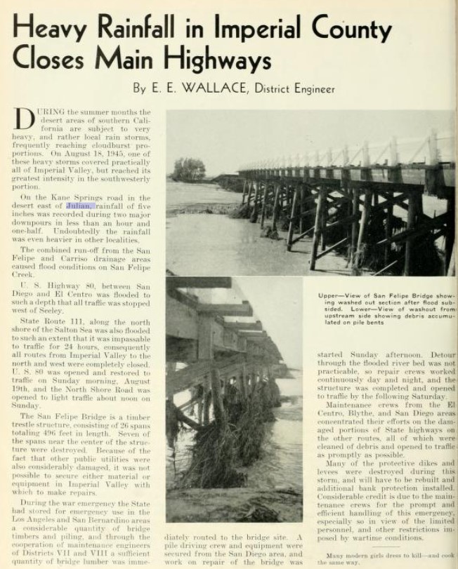
The September/October 1945 California Highways & Public Works references a closure of CA 78/LRN 198 between Julian and Kane Springs following heavy rains. A washed-out bridge over San Felipe Creek on CA 78/LRN 198 is featured in the article.
The modernization of US Route 395/LRN 77 between San Diego and Riverside appears in an article in the November/December 1946 California Highways & Public Works. The new alignment of US Route 395/LRN 77 once complete would provide a direct north/south routing between San Diego and Riverside by way of Escondido. The new alignment of US Route 395/LRN 77 once complete would remove the multiplex of CA 78 between Vista and Escondido.
1947 Legislative Chapter 1233 altered the definition of LRN 196 as terminating at Vista instead of LRN 77.
The planned new alignment of US Route 395/LRN 77 between San Diego and Riverside appears on the 1948 Division of Highways Map.
The November/December 1950 California Highways & Public Works featured the opening of the new 18.3-mile alignment of US Route 395/LRN 77. The new alignment of US Route 395/LRN 77 was routed directly north from Miramar towards Temecula via Escondido. The new alignment of US Route 395 left CA 78 left alone aligned over what had been LRN 77 between Vista-Escondido.
The 1951 Division of Highways Map displays the new alignment of US Route 395/LRN 77 through Escondido. CA 78 on what had been LRN 77 between Vista-Escondido is shown to be not a State Highway. LRN 196 appears on the map insert as Oceanside to Vista as per the provisions of 1947 Legislative Chapter 1233.
1951 Legislative Chapter 1562 extended LRN 196 from Vista to LRN 77 in Escondido. This measure brought CA 78 between Vista-Escondido back under state maintenance as part of LRN 196. CA 78/LRN 196 in the Vista-Escondido corridor appear on the 1952 Division of Highways Map.
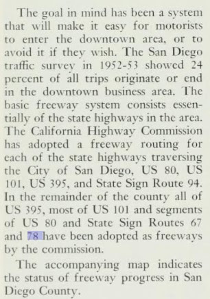
The junction of US Route 101 and the CA 78/LRN 196 interchange at Vista Avenue in Oceanside appears in the November/December 1955 California Highways & Public Works. A second photo shows CA 78/LRN 196 on Vista Avenue between Oceanside and Vista. The accompanying article note a segment of CA 78 (Oceanside-Escondido) had been adopted as a freeway corridor by the California Highway Commission as part of a 1952-53 San Diego area traffic survey. CA 78/LRN 196 on Vista Avenue between Oceanside-Vista is shown to be built to expressway standards. CA 78/LRN 196 east of Vista to Escondido is shown to be under study for freeway conversion.
1959 Legislative Chapter 1062 changed the origin of LRN 146 from Palo Verde near the Imperial County Line to LRN 187 (CA 115) east of Brawley. The newly extended segment of LRN 146 contained a planned routing over the Algodones Dunes by way of Glamis and appears on the 1960 Division of Highways Map.
The entire planned corridor of the CA 78/LRN 196 freeway between Oceanside and Escondido was added to the Freeways and Expressway System during 1959. The January/February 1960 California Highways & Public Works notes funding had been made available to construct the CA 78/LRN 196 freeway near Escondido.
1961 Legislative Chapter 1387 changed the definition of LRN 146 between CA 115/LRN 187 and the Riverside County Line:
"Notwithstanding the provisions of Section 89 of Chapter 1062, Statutes of 1959, the department shall proceed with construction of the unconstructed portion of said route described in subdivision (a) between the junction of LRN 187 and the Imperial-Riverside county line with the lowest practical cost for a hard surfaced road and as an interim project pending the later construction of the route to proper limited access standards; provided that prior thereto the County of Imperial enters into a co-operative agreement with the department wherein the county agrees to maintain the road between the junction of LRN 187 and the Imperial-Riverside County Line until a limited access highway is constructed by the department between said points. Upon the completion of construction of said interim road and pursuant to said agreement, the county shall assume jurisdiction and all responsibilities of maintenance for the period above provided. The road shall be known and designed as the "Ben Hulse Highway.""
The September/October 1961 California Highways & Public Works displays the adopted US Route 395/LRN 77 freeway corridor in Escondido in relation to existing CA 78. An adopted routing of the CA 78/LRN 196 freeway west from existing US Route 395 in downtown Escondido is displayed.
The January/February 1962 California Highways & Public Works notes LRN 146 had a formal route adoption from Glamis to towards Palo Verde by the California Highway Commission during late year 1961. Much of LRN 146 in the Glamis-Palo Verde corridor is noted to have been adopted as expressway standard.
The November/December 1963 California Highways & Public Works noted CA 78/LRN 178 had been constructed to freeway standards by February 1963 from Vista five miles eastward. A project to connect the freeway eastward to US Route 395/LRN 77 in Escondido is stated to be underway.
As part of the 1964 State Highway Renumbering all the Legislative Route Numbers were dropped in favor of what was field signed as Sign State Routes. CA 78 was subsequently given a new definition which appears on the 1964 Division of Highways Map as Route 5 (Interstate 5) near Oceanside to Route 10 (Interstate 10). CA 78 can be seen multiplexing CA 86 from Kane Springs through Brawley to the unbuilt segment east of CA 115. As defined during the 1964 State Highway Renumbering CA 78 multiplexed CA 86 into Brawley via Main Street. CA 86 split south towards El Centro at 1st Street in Brawley whereas CA 78 continued east on Main Street to Ben Hulse Highway.
The January/February 1965 California Highways & Public Works noted that CA 78 been moved fully to a freeway grade between Vista and Escondido (on December 21st, 1964). The stub notes the entirety of CA 78 was part of the Freeways and Expressways System. Upgrades to CA 78 from Vista west to Oceanside as a freeway are stated to be underway. The new freeway alignment of CA 78 in Escondido terminated at Broadway. CA 78 initially followed existing US Route 395 south to Grand Avenue. During 1968 much of what had been CA 78 on Mission Road and Santa Avenue in the Escondido-Vista corridor was designated as San Diego County Route S14.
The California Highways & Public Works ended during 1967 without resolution to the unconstructed portion of CA 78 between CA 115 to Palo Verde. A completed road (Ben Hulse Highway) between CA 115 and Palo Verde appears on the 1967 Division of Highways Map as planned CA 78. Only CA 78 from Glamis to Palo Verde is shown to have a determined State Highway routing.
Notably Ben Hulse Highway between CA 115 to existing CA 78 near the Riverside County Line appears as Imperial County Route S78 on the 1966 Department of Public Works Map.
The construction of a road to Glamis was difficult to due to the presence of the Alogodones Dunes. The most practical route from Brawley to Blythe was initially via Niland-Brawley Road through the Chocolate Mountains which can be seen on the 1935 Division of Highways Map of Imperial County.
Within Riverside County Niland-Brawley Road emerged onto the Bradshaw Trail which ended at LRN 146 several miles north or Palo Verde which can be seen on the 1935 Division of Highways Map of Riverside County.
During the California Gold Rush a wagon route known as the Bradshaw Trail was plotted through the Sonoran Desert by William D. Bradshaw. The Bradshaw Trail was plotted in 1862 through the Sonoran Desert east over the Colorado River to a new mining strike found in La Paz, Arizona. Bradshaw consulted the Cahuilla Tribe who advised him the best route was through a pass between the Orocopia Mountains and Chocolate Mountains. From the Chocolate Mountains the Bradshaw Trail passed through the southern Chuckwalla Range and a pass through the Mule Mountains to Bradshaw's Ferry on the Colorado River near modern day Blythe. The Bradshaw Trail was the predecessor to what would become US Route 60/US Route 70 on LRN 64. The 1873 Bancroft's Map of California, Nevada, Utah and Arizona depicts the Bradshaw Trail east of Salton Sink to the Colorado River.
The Chocolate Mountains were turned over to the United States Navy to make way for the Chocolate Mountain Aerial Gunnery Range during the 1940s. The formation of the Gunnery Range in the Chocolate Mountains rendered Niland-Brawley Road north of Niland largely inaccessible to the general public due to the presence of bombing runs closing it most days of the week. Initial plans to construct a road from Brawley to the Southern Pacific Railroad siding of Glamis first emerged during 1953 (seen in a San Diego Tribune article dated April 12th, 1953, under the title "Glamis Road would cut travel time").
During February 1956 the House Armed Services Committe (from a San Diego Union article dated to February 29th, 1956) voted to allocate $660,000 dollars for the Navy to given to Imperial County to construct a new road from Brawley to Glamis. The Glamis Road was part of a 616 project House Appropriations Bill which had initially been vetoed by President Dwight Eisenhower during July 1956. The Glamis Road was ultimately approved weeks later which had been reported by the San Diego Union on July 30th, 1956. Existing Niland-Brawley Road in the Chocolate Mountains was sold to the Navy during February 1957 to fund construction the Glamis Road. California State Senator Ben Hulse is quoted in a Los Angeles Times article from the era predicting the Glamis Road would become a State Highway.
The road connecting Brawley to Glamis opened on August 13th, 1958, according to a San Diego Tribune article. The opening of the new road to Glamis saw it incorporated into the planned extension of LRN 146 defined by 1959 Legislative Chapter 1062. The completion of Ben Hulse Highway from CA 115 to existing CA 78 near Palo Verde was reported as being dedicated in the March 22nd, 1964, San Diego Union. Ben Hulse Highway reported was signed as Imperial County Route S78 upon being dedicated. Ben Hulse Highway ultimately appears as part of CA 78 on the 1970 Division of Highways Map. Notably the 1970 Division of Highways Map still shows the planned alignment approved by the California Highway Commission during 1961.
Ultimately CA 78 west of Vista to Interstate 5 in Oceanside was constructed to freeway standards from 1967 through 1973. CA 78 appears as a full freeway between Oceanside and Vista on the 1975 Caltrans Map.
The 1975 Caltrans Map displays the planned alignment of CA 78 abandoned between CA 115 and Palo Verde in favor of existing Ben Hulse Highway.
Following the completion of Interstate 15 in Escondido CA 78 was shifted to a new alignment east of new corridor. CA 78 eastbound followed the end of its freeway grade and turn onto Broadway. From Broadway CA 78 followed Washington Avenue to reach its existing alignment at Ash Street. This alignment of CA 78 in Escondido first appears on the 1979 Caltrans Map and is still retained in the modern highway.
Traditionally CA 78 between Oceanside and Escondido was often to referred to as the "Anza Freeway." The corridor was named "Ronald Packer Parkway" as part of Concurrent Resolution 165, Chapter 124, on September 5th, 2000. Ronald Packard was a congressman from the 48th Congressional District and the Chairperson of the North County Transit District of San Diego County.
During 2012 CA 78 was moved onto the Brawley Bypass which originated west of Brawley. The Brawley Bypass included a multiplex of CA 78 and CA 111 originating at Old Highway 111 east to Ben Hulse Highway. The former alignment of CA 78 on Main Street in Brawley was authorized for relinquishment by the California Transportation Commission during October 2012.
Part 2; Roadwaywiz on California State Route 78
During October 2020 Dan Murphy featured real-time drives on CA 78 on the Ronald Packard Parkway between Interstate 5 in Oceanside and Interstate 15 in Escondido. Below CA 78 eastbound on the Ronald Packard Parkway can be viewed.
Below CA 78 on Ronald Packer Parkway can be viewed from Escondido to Oceanside.
The Pre-Emption Road (or rather a series of roads named Pre-Emption Road) follows a survey line called the Pre-Emption Line, drawn in the early days of the United States. The story begins with Massachusetts and New York having competing land claims to modern day Western New York State that have their roots in colonial charters granted by the British. After the Revolutionary War ended, this land became the frontier of the nation and its settlement became a priority for the new American government. During this era, there were a lot of competing land claims that needed to be settled. It was no different with the land claims between New York State and Massachusetts. On November 30, 1786, Massachusetts and New York sent representatives to Hartford, Connecticut to resolve their competing land claims. In less than three weeks, the representatives had reached a compromise. Massachusetts would receive pre-emption rights, meaning the right to sell the land after the Indian title ...
Our tagline on the Gribblenation blog is "because every road tells a story". Some roads tell different stories than others. Along our travels, we may see historic markers that tell us a little story about the roads we travel or the places we pass by. Some historic markers are more general, as to telling us who lived where or what old trail traversed between two towns. During my travels across New York State and other states or provinces, I pass by many historic markers, some with interesting or amusing references to roads. I wanted to highlight a few of the markers I've seen along my travels around the Empire State and help tell their stories. Those stories may be as specific as explaining the tales of a tree that was used to help measure a distance of eight miles from Bath to Avoca in Steuben County, as referenced on the Eight Mile Tree historical marker above. They may also help point the way along historical roads first used centuries ago, or may help tell a local l...
After leaving Barstow via Old Highway 58 my next destination was in Death Valley. To access Death Valley from rural San Bernardino County required a trek on north on Interstate 15 to California State Route 127 which becomes Nevada State Route 373 at the state line. Along I-15 I encountered the road sign oddity that is Zzyzx Road about eight miles south of Baker. Zzyzx Road is a four mile road that used to go to the Zzyzx Mineral Springs and Health Spa. The spa was founded in the 1940s and the owner made up the name "Zzyzx" to claim it was the last word in the English Language. The spa has been shut down since the 1970s and is now part of a Desert Studies Center for California State University. The southern terminus of CA 127 in Baker is located at I-15 exit 246. CA 127 is a 91 mile north/south highway which runs to the Nevada State Line in Inyo County. CA 127 is called Death Valley Road from I-15 northward. South of CA 127 ...


Comments