In this article we look at the history of California State Route 254 which is more popularly known as Avenue of the Giants. Avenue of the Giants is a former segment of US Route 101/Redwood Highway.

California State Route 254 ("CA 254") is a 32 mile former segment of US Route 101 in Humboldt County. CA 254/Avenue of the Giants features one of the largest Coastal Redwood strands in Northern California which line a highly scenic driving route.

Part 1; the history of US Route 101, the Redwood Highway, and CA 254/Avenue of the Giants
The history of what would become US Route 101 ("US 101") and the Redwood Highway over what is now CA 254/Avenue of the Giants begins with the approval of the 1909 First State Highway Bond Act. The First State Highway Bond Act was approved by voters during 1910 and was the genesis point of some of the most notable highways in California. Legislative Route 1 ("LRN 1") in it's original form was a new State Highway which was designated between San Francisco north to Crescent City. The route of LRN 1 would be extended to the Oregon State Line during the 1919 Third State Highway Bond Act and was known as the Redwood Highway.
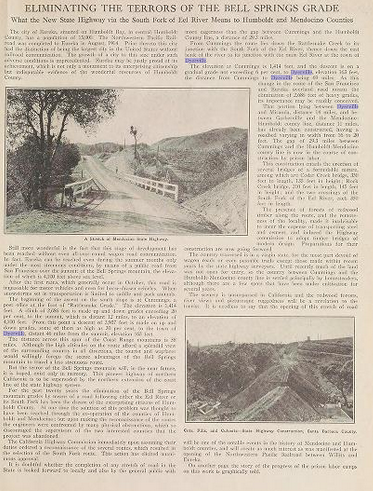
The July 1916 California Highway Bulletin discusses the construction of 14 miles of the Redwood Highway/LRN 1 from Miranda north to Dyerville. This segment of the Redwood Highway would in decades become part of CA 254/Avenue of the Giants.
The early Redwood Highway/LRN 1 is shown in south of Fortuna towards Miranda on the 1917 California State Automobile Association Map.

The Redwood Highway/LRN 1 is listed as an Auto Trail on the 1920 Clason Highway Map of California.

The initial draft of the US Route System was approved by the Secretary
of Agriculture during November of 1925. The US Route System with in
California was approved by California Highway Commission with no changes
recommended by January 1926. US Route 101 was largely planned to follow the Redwood Highway south from Crescent City towards San Francisco. The proposed US Route 101 can be seen in the January 1926 California Highways & Public Works.


Thusly US 101 appears on the 1925 Rand McNally Map of California as being routed over the Redwood Highway of Humboldt County.


The July 1931 California Highways & Public Works announced the purchase of Coastal Redwoods by the Save the Redwoods League from the Bull Creek and Dyerville Groves which were to be incorporated into Humboldt Redwoods State Park. Humboldt Redwoods State Park had been established previously in 1921.


The January/February 1956 California Highways & Public Works details the damage caused by flooding due to a major storm in December 1955. Numerous segments of US 101/LRN 1 on the Redwood Highway are shown to have been heavily damaged, including near Weott on a Division of Highways District I report.


The March/April 1957 California Highways & Public Works discusses the modernization of US 101/LRN 1 in Humboldt County. The first segment of the Redwood Freeway slated to be constructed was a segment from Englewood south to the vicinity of Dyerville. The Redwood Freeway is cited to be planned to continue south from Dyerville to the Mendocino County Line. Population increases in Humboldt County, traffic, and even rainfall were all cited as reasons for the expansion of US 101/LRN 1 via the Redwood Freeway project.


The November/December 1959 California Highways & Public Works features a report from Division Highways District I on the expansion of US 101/LRN 1. The "Redwood Parks Freeway" is cited to recently had a second segment completed from Myers Flat 7.5 miles north to the vicinity of Dyerville. This second segment of the Redwood Parks Freeway connected with the first completed segment which continued another 4.4 miles northward. The recently bypassed portions of US 101 from Myers Flat to the vicinity of Englewood were retained under State Control as a spur of LRN 1 and would form the basis for Avenue of the Giants.


The recently completed Redwood Parks Freeway can be seen on the 1960 Division of Highways State Map as US 101/LRN 1 north of Dyerville.

The September/October 1960 California Highways & Public Works announced that 25 miles of former US 101/LRN 1 north from Miranda would be maintained by the State Division of Parks and Beaches as Avenue of the Giants. Avenue of the Giants was announced on August 27th, 1960 by then Governor Edmund G. Brown.

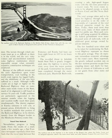
The September/October 1963 California Highways & Public Works notes that the State had formalized it's commitment to maintaining Avenue of the Giants by giving it a specific routing definition.

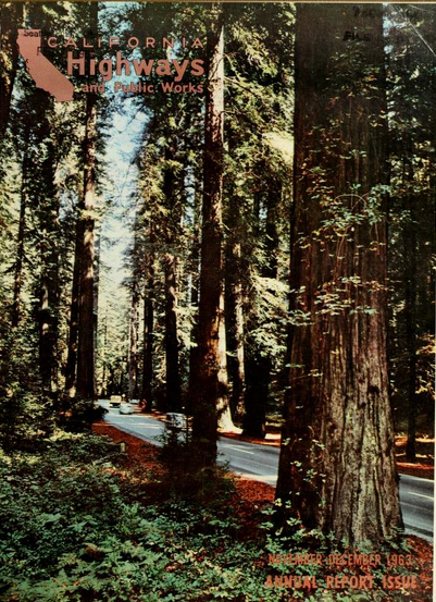
Avenue of the Giants is featured on the cover the November/December 1963 California Highways & Public Works.

According CAhighways.org the Legislation that added Avenue of the Giants formally to the State Highway System was Chapter 890 which was duplicated by Chapter 901. Avenue of the Giants was assigned Legislative Route Number 296 which was replaced by CA 254 for the 1964 Highway Renumbering. The initial definition of CA 254 can be seen on the 1964 Division of Highways State Map as; "Avenue of the Giants, comprising a former portion of Redwood Highway through and
connecting a number of state parks, from Route 101 near the Sylvandale
interchange to Route 101 near the Redcrest interchange." Notably US 101 can be seen with a Legislative Route Number of 254 from Phillipsville north to Myers Flat on the 1964 Division of Highways Map as the new alignment of US 101 had not been built yet.


The 1965 Division of Highways State Map shows US 101 bypassing Phillipsville and Miranda to Myers Flat. The former segment of US 101 is shown legislatively as part of Route 254.

According to CAhighways CA 254/Avenue of the Giants was given an updated route definition as part of 1967 Legislative Chapter 1331; "The Avenue of the
Giants, comprising a portion of the former Redwood Highway through and
connecting a number of state parks, from Route 101 near the Sylvandale
interchange to Route 101 near the Redcrest interchange one-tenth
of a mile north of Jordan Creek.”
Part 2; a drive on California State Route 254/Avenue of the Giants
US 101 southbound intersects the northern beginning of CA 254/Avenue of the Giants at Exit 674 near Pepperwood.


CA 254/Avenue of the Giants southbound crosses under US 101 to the banks of the Eel River and enters the North Tract of Humboldt Redwoods State Park. Travelers on CA 254/Avenue of the Giants are notified that Auto Tour information is provided by Humboldt Redwoods State Park.


The North Tract of Humboldt Redwoods State Park consists of a thick grove of Coastal Redwoods which are perfect for glory photos of Avenue of the Giants.


Said glory photo would be of CA 254/Avenue of the Giants looking northbound below.

CA 254/Avenue of the Giants south briefly leaves the North Tract of Humboldt Redwoods State Park and enters Pepperwood at Postmile HUM 43.992. Pepperwood had Post Office Service on and off from 1887 to to 1965. Pepperwood was largely obliterated by the 1964 Christmas Flood.


CA 254/Avenue of the Giants south reenters the North Tract of Humboldt Redwoods State Park. At Postmile HUM 43.36 CA 254/Avenue of the Giants south intersects an unnamed road over the Eel River which is signed as access to Shively.


CA 254/Avenue of the Giants is signed as 10 miles from Weott and 17 miles from Myers Flat.

At Postmile HUM 41.09 CA 254/Avenue of the Giants south intersects Holmes Flat Road.


CA 254 does not have many reassurance shields on Avenue of the Giants. Most reassurance CA 254 shields can be found at the end of intersecting roads such as Holmes Flat Road. Holmes Flat was named after a lumber company executive and is located approximately a mile east of CA 254.

CA 254/Avenue of the Giants south enters Redcrest at Postmile 39.88. Redcrest had a Post Office open in 1965 and seems to be where much of Pepperwood relocated to after the 1964 Christmas Flood.


CA 254/Avenue of the Giants south of Redcrest enters the main annex of Humboldt Redwoods State Park at Postmile HUM 24.17 (the Postmiles jump near Englewood Road from approximately 39.15).

CA 254/Avenue of the Giants south passes by High Rocks Conservation Camp at Postmile HUM 22.37.


CA 254/Avenue of the Giants south splits from the main branch of the Eel River and begins to follow the course of the South Fork Eel River near what was once Dyerville at Postmile HUM 20.877. Dyerville was once a ferry landing that was settled in the 1870s and was destroyed during the floods of 1955 described in Part 1.


CA 254/Avenue of the Giants south crosses the South Fork Eel River at Post Mile HUM 20.76.


At Postmile HUM 20.56 CA 254/Avenue of the Giants south intersects Dyerville Loop Road. Note; the high water mark of the 1964 Christmas Flood can be seen as CA 254 intersects Dyerville Loop Road.


CA 254/Avenue of the Giants south crosses over modern US 101 and enters Weott at Postmile HUM 18.79. Weott was established as a fishing village in 1925 but the 1955 floods and 1964 Christmas Flood destroyed much of the original community site. Modern Weott is located east of US 101 above the flood pain.


From Weott CA 254/Avenue of the Giants is signed as 6 miles from Myers Flat and 12 miles from Miranda.

South of Weott CA 254/Avenue of the Giants passes by the Eel River Sector Headquarters.


At Postmile HUM 13.53 CA 254/Avenue of the Giants passes by the Williams Grove Day Use Area.


CA 254/Avenue of the Giants south enters Myers Flat at Postmile HUM 12.73. Myers Flat was founded in the 19th Century by the Myers Family and the community was oriented towards stage travel from San Francisco. Most of Myers was destroyed during the 1964 Christmas Flood but it was largely rebuilt on the South Fork Eel River Flood Plain.


CA 254/Avenue of the Giants south crosses under US 101 and is signed as 6 miles from Miranda.


CA 254/Avenue of the Giants south intersects Elk Creek Road at Postmile HUM 10.50.


CA 254/Avenue of the Giants south leaves the main annex of Humboldt Redwoods State Park enters Miranda at Postmile HUM 6.61. The community name of Miranda was given in 1905 when Post Office service was established. Unlike most of the communities on CA 254 Miranda seems to have been relatively unaffected by mid-20th Century flooding as it lies at an elevation of 351 feet above sea level.


CA 254/Avenue of the Giants south of Miranda is signed 3 miles from Phillipsville.


CA 254/Avenue of the Giants south passes through the South Tract of Humboldt Redwood State Park and enters Phillipsville at Postmile 2.69. Phillipsville was settled in 1865 as Phillips Flat by George Stump Phillips and went by the name of Kettinteble for a time. The name of the community changed to Phillipsville in 1948 when Post Office service had been reestablished.


South of Phillipsville CA 254/Avenue of the Giants terminates at US 101 (at US 101 Exit 645).


Comments