This past month I drove California State Route 44 from Lassen Volcanic National Park west to Redding. California State Route 44 contains an interesting back story which has origins as California State Route 440.

California State Route 44 ("CA 44") is a 105 mile east/west State Highway. CA 44 originates at CA 273/CA 299 in downtown Redding of Shasta County, traverses eastward into the Cascade Mountains, and terminates at CA 36 near Susanville of Lassen County.

Part 1; the history of California State Route 44
The origins of CA 44 date back to 1933 when Legislative Route 20 ("LRN 20") was extended east from Redding to Lassen Volcanic National Park. This extension of LRN 20 was meant to reach the northern terminus of Lassen Park Highway which had been completed through Lassen Volcanic National Park in 1931. LRN 20 between Redding and Lassen Volcanic National Park first appears on the 1934 Division of Highways State Map.


In the August 1934 California Highways & Public Works the Sign State Routes were announced. CA 440 was announced as a new State Highway running from Redding east over LRN 20 to Lassen Volcanic National Park. CA 44 was announced as a new State Highway running from US 101 near Arcata east to CA 7 in Alturas via Redding.

The original CA 44 was quickly swapped to US Route 299 by 1935. The approval of US 299 was concurrent with that of US Route 395 which replaced most of CA 7. CA 440 appears to have been a placeholder designation pending the approval by the AASHO of US Route 299. Nonetheless CA 440 appears alongside US Route 299 on the 1935 Gousha Map of California.

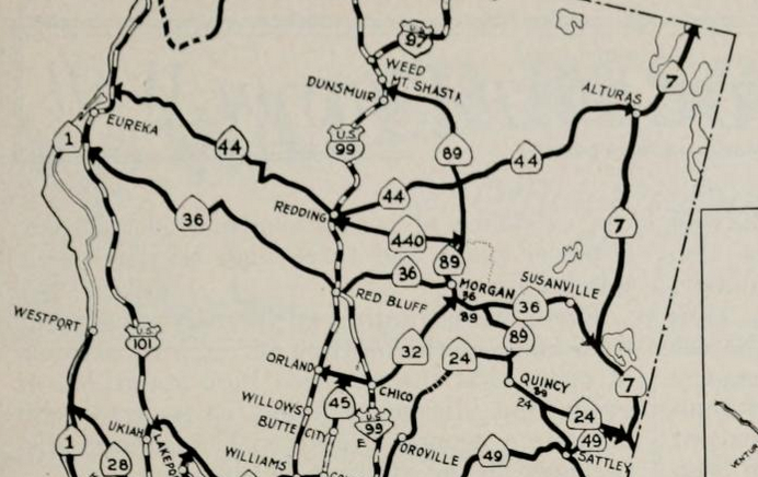
CA 440 originated on the outskirts of Redding near the east bank of the Sacramento River at US 299. The original alignment of CA 440 split from US 299 east of the 1908 Redding Free Bridge near what is now the intersection of Parkview Avenue and Hartnell Avenue. From US 299 the route of CA 440 followed modern, Cypress Avenue, Church Creek Road, Hartnell Avenue and Old 44 Drive to east to Millville. The early alignments of US 299 and CA 440 can be seen on the 1935 California Division of Highways Map of Shasta County. For illustrative purposes highway shields were placed over the 1935 Division of Highways Map below to highlight the highway grid around Redding more clearly.

The March 1938 California Highways & Public Works
details the three phase project to improve US 99/US 299/LRN 3 north of
downtown Redding and the Sacramento River. Phase 1 included the
completion of the 795 foot long plate girder 1935 Sacramento River Bridge.
The 1935 Sacramento River Bridge likely played a huge factor in why the
original CA 44 was reassigned as US Route 299 during 1935. Phase 2
included a new direct alignment of US 99/US 299/LRN 3 on Market Street
from the north bank of the Sacramento River to Sulpur Creek which was
completed in December 1935. Phase 3 was completed during July 1937
between Sulpur Creek and Boulder Hill. The Phase 3 project included a
new interchange where US 299/LRN 28 split towards Alturas. The shift in US 299 extended CA 440 west over the 1908 Redding Free Bridge via what is Smile Place and Parkview Avenue to US 99/Market Street south of downtown Reding


The January 1936 California Highways & Public Works
contains more detail of the opening of the 1935 Sacramento River Bridge
and the former alignment of US 99/LRN 3. The new Sacramento River
Bridge is cited have an opening ceremony on December 18th. This date is likely when CA 440 was extended to US 99.


At some point between 1935-1937 CA 440 was reassigned as CA 44. The current CA 44 first appears on the 1937 Gousha Highway Map of California.

The September/October 1947 California Highways & Public Works cites that construction a 1.5 mile new route for CA 44 east of US 99 along with a new bridge over the Sacramento River was budgeted for 1948. This new alignment of CA 44 is what is now modern day Cypress Avenue in Redding east over the Sacramento River to Hartnell Avenue.

According to CAhighways.org 1959 Legislative Chapter 1062 extended LRN 20 eastward with the following two new segments:
- [LRN 83] near Old Station to [LRN 29] W of Susanville
- [LRN 29] near Susanville to [LRN 73] near Ravendale.
Both new segments of LRN 20 first appear on the 1960 Division of Highways Map east of CA 44 as planned highways.

LRN 20 between Old Station and Susanville appears as State Maintained and part of a new segment of CA 44 on the 1962 Division of Highways State Map.

During the 1964 State Highway Renumbering all Legislative Route Numbers were dropped. CA 44 was given a Legislative Definition of; "(a) Route 5 at Redding to Lassen Volcanic National Park. (b) Lassen Volcanic National Park to Route 36 west of Susanville." These changes can be seen on the 1964 Division of Highways State Map.


The November/December 1964 California Highways & Public Works cites that the new CA 44 bypass alignment of Palo Cedro east towards Millville was completed in October. A new freeway alignment of CA 44 originating from US 99/Market Street in Redding eastward over the Sacramento River was cited to be under construction.

A new freeway alignment of CA 44 east of Redding appears on the 1969 Division of Highways Map along with new planned route east of Millville to Shingletown. The construction of the new CA 44 freeway segment appears to have occurred concurrently with Interstate 5 in the Redding Area.

The planned realignment of CA 44 between Millville and Shingletown appears to have been cancelled in the 1980s as it no longer appears beginning on the 1986 Caltrans State Map.

According to CAhighways.org the Legislative Definition of CA 44 changed in 1999 with it's west terminus from being swapped from I-5 to CA 299. In 2002 CA 299 was multiplexed north with CA 273 on Market Street out of downtown Redding to Lake Boulevard. This change in CA 299 shifted CA 44 into downtown Redding where it presently terminates at CA 273/CA 299 at Market Street. The present alignment of CA 44 in downtown Redding appears on the 2005 Caltrans State Map.

Part 2; a drive on California State Route 44 from Lassen Volcanic National Park west to Redding
My drive on CA 44 westbound began at the north terminus of Lassen Park Highway. Lassen Park Highway is the implied alignment of CA 89 through Lassen Volcanic National Park. From the north terminus of Lassen Park Highway a left hand turn takes traffic on CA 44 westward towards Redding whereas a right hand turn takes traffic onto CA 44 east/CA 89 north. Redding is signed as 48 miles to the west whereas Susanville is signed as 66 miles to the east.

CA 44 west follows Manzanita Creek towards the boundary of Lassen National Forest at approximately Postmile SHA 45.8.


CA 44 west enters the community of Viola at Postmile SHA 42.911. CA 44 intersects Brokeoff Meadows Road in Viola.


CA 44 west of Viola is a rare example of a 65 MPH two lane State Highway.


Oddly CA 44 west of Viola is signed as a "DUI Safety Corridor."


Shingletown is shown as 9 miles from Viola on CA 44 westbound.

West of Viola CA 44 passes by a rest area facility.


At Postmile SHA R27.777 enters Shingletown.


Palo Cedro is signed as 20 miles from Shingletown on CA 44 westbound.

CA 44 west of Shingletown begins a lengthy descent alongside Shingle Creek.


CA 44 west continues to descend and intersects Sign County Route A17/Dersch Road at Postmile R19.017.


Redding is signed as 18 miles away on CA 44 west from Sign County Route A17.


Comments