
Last Sunday was a great Autumn afternoon, here in Central North Carolina. So I took a small road trip into Granville, Person and Caswell Counties. I also got into Virginia a little bit as well.
Route: NC 50, NC 56, I-85, US 15, US 58, VA/NC 49, NC 57, NC/VA 119, US 58/360, VA/NC 62, I-40, I-540.
This zig-zag trip picked up some new miles in North Carolina (NC 49, NC 119, NC 62) and Virginia (VA 49 and 119). Over 60 photos on flickr.
My first stop was a small town on US 15 north of Oxford...called Stovall.

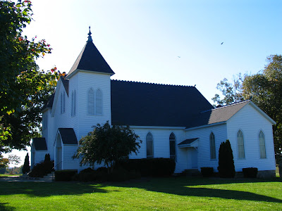
That's the rail sign for Stovall on the abandoned (not sure which line) tracks through town. There are a number of small churches in Stovall...and this one is across the street from the Stovall United Methodist Church...but there's nothing to say what it is. Anyone know?
 In Virginia, I grabbed the small piece of the US 58 Clarksville Bypass that I hadn't been on. It's 60 mph...but the section west of US 15 does have two at grade intersections. But so it doesn't seem like I ignored the Commonwealth on this trip...here's a photo of US 58/VA 49 just west of US 15.
 (Yes, I get out of my vehicle a lot to take photos.)
Along NC 57, I stopped at the tiny crossroads of Concord. There's another church (Concord United Methodist) and cemetery, and it allowed for some great photos.


 At Semora, where NC 57 meets NC 119, I took some sign shots...and here's the result of a framing experiment I did.

 Which one is better...and I know I need more work on this type of photography style.
Stopped along NC 62 at the crossroads of Hamer. I really like this shot...the sign was slightly higher than eye level.

Finally, I got the chance to walk around the Caswell County Seat of Yanceyville. It's just off of US 158 on the old alignment through town. It also includes a courthouse square, and one of the more visually pleasing courthouses in the state.


 Here are a few other views of Yanceyville..and yes in Caswell County they use Clearview on Street sign blades.


Route: NC 50, NC 56, I-85, US 15, US 58, VA/NC 49, NC 57, NC/VA 119, US 58/360, VA/NC 62, I-40, I-540.
This zig-zag trip picked up some new miles in North Carolina (NC 49, NC 119, NC 62) and Virginia (VA 49 and 119). Over 60 photos on flickr.
My first stop was a small town on US 15 north of Oxford...called Stovall.

That's the rail sign for Stovall on the abandoned (not sure which line) tracks through town. There are a number of small churches in Stovall...and this one is across the street from the Stovall United Methodist Church...but there's nothing to say what it is. Anyone know?
 In Virginia, I grabbed the small piece of the US 58 Clarksville Bypass that I hadn't been on. It's 60 mph...but the section west of US 15 does have two at grade intersections. But so it doesn't seem like I ignored the Commonwealth on this trip...here's a photo of US 58/VA 49 just west of US 15.
 (Yes, I get out of my vehicle a lot to take photos.)
Along NC 57, I stopped at the tiny crossroads of Concord. There's another church (Concord United Methodist) and cemetery, and it allowed for some great photos.


 At Semora, where NC 57 meets NC 119, I took some sign shots...and here's the result of a framing experiment I did.
 Which one is better...and I know I need more work on this type of photography style.
Stopped along NC 62 at the crossroads of Hamer. I really like this shot...the sign was slightly higher than eye level.

Finally, I got the chance to walk around the Caswell County Seat of Yanceyville. It's just off of US 158 on the old alignment through town. It also includes a courthouse square, and one of the more visually pleasing courthouses in the state.


 Here are a few other views of Yanceyville..and yes in Caswell County they use Clearview on Street sign blades.


Comments