Hawaii Route 64

Hawaii Route 64 is a 2.6 mile State Highway contained within the City of Honolulu.  Hawaii Route 64 begins at Hawaii Route 92/Nimitz Highway and follows Sand Island Access Road and Sand Island Parkway to Sand Island State Recreation Area.  Hawaii Route 64 is the only road to access Sand Island in the City of Honolulu which crosses the Honolulu Harbor Bridge. 


This page is part of the Gribblenation Hawaii Roads series.  A compellation of all Hawaii-related media from both Gribblenation and RoadwayWiz can be found by clicking here


Part 1; the history of Hawaii Route 64

Sand Island was originally known as Kamoku'akulikuli and came to be known as Quarantine Island following a quarantine station being constructed there during 1872.  Quarantine Island was expanded during 1888 via use of landfill.  Quarantine Island was used to impound ships attempting access Honolulu Harbor which had potentially contagious passengers.  Quarantine Island can be seen on the 1899 Taylor Map of O'ahu just offshore from Honolulu.  

The 1901 George Franklin Cram Map of Honolulu displays a low tide carriage road from Quarantine Island in addition to a Pier/Tramway to Quarantine Wharf.  Quarantine Island was enlarged again via landfill during 1906 and was surrounded by a sea wall.  During 1916 the Sand Island Military Reservation was established which led to numerous improvements to Sand Island and Honolulu Harbor. 

Prior to the Statehood the first signed highways within Hawaii Territory came into existence during World War II.   During World War II the territory of Hawaii saw an influx of military activity following the attack on Pearl Harbor on December 7th, 1941.  Numerous Military Routes and early Hawaii Routes were signed through the Hawaiian Territory to aid military personnel in navigating the islands.  Military Highways were assigned US Route style shields whereas lesser highways were assigned an early variation of what is now the Hawaii Route Spade.  

A 1946 Army Map of the Island of O'ahu shows no World War II era Hawaii Routes or roads accessing Sand Island.  During World War II was used an Army Interment Camp which opened immediately after the attack on Pearl Harbor.  The Sand Island Army Interment Camp housed Hawaiians of Japanese descent and others living in Hawaii born in Axis Power Countries.  The Sand Island Army Interment Camp closed during March of 1943 with most of the prisoner population transferred to the Mainland United States or Honouliuli Interment Camp.  A full version of the 1946 Army Map of O'ahu can be seen on hawaiihighways.com here


Circa 1955 following the conclusion of World War II the United States Bureau of Public Roads renumbered the Hawaii Route System.  The 1955 Hawaii Route Renumbering saw most of the conventions utilized by the current Hawaii State Route System established.  Primary Hawaii Routes were given two digit numbers whereas Secondary Hawaii Routes were given three digit numbers.  The Hawaii Routes were assigned in sequence for what Island/County they were located on coupled with what Federal Aid Program number they were tied to.  In the case of O'ahu the Island was assigned numbers in the range of 60-99.

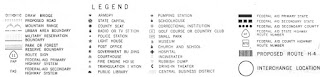
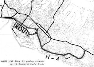
During 1959 Sand Island was turned over by the U.S. Army to the Territory of Hawaii.  On August 21st, 1959 Hawaii became the 50th State which saw it's profile rise significantly.  During April 1962 the Army Corps of Engineers completed the two-lane Lt. John R. Slattery Bridge as bascule draw span.  The completion of the Lt. John R. Slattery Bridge saw Sand Island Access Road added to the Hawaii Route System as Hawaii Route 640.  Hawaii Route 640 on Sand Island Access Road to the Lt. John R. Slattery Bridge can be seen on a 1968 concept drawing of Interstate H-4. 


Below the Lt. John R. Slattery Bridge can be seen in undated photo from oldimagesofhawaii.com allowing a ship to pass through the draw span.  


During the 1980s the Lt. John R. Slattery Bridge was permanently sealed and an adjacent concrete span was built next to it to allow for four lane capacity for freight vehicles.  It is unclear but it appears the expansion of the Lt. John R. Slattery Bridge was when State Maintenance extended to Sand Island State Recreation Area and Hawaii Route 640 was reassigned as Hawaii Route 64.  What was known as the Lt. John R. Slattery Bridge is presently known as the Honolulu Harbor Bridge


Part 2; a eastbound drive on Hawaii Route 64

Below the junction of Hawaii Route 64 eastbound from Hawaii Route 92/Nimitz Highway can be observed.  


Below Hawaii Route 64 eastbound can be seen crossing the Honolulu Harbor Bridge from Sand Island Access Road to Sand Island Parkway.  


During May 2019 Dan Murphy of the Roadwaywiz Youtube Channel and Gribblenation featured a real-time drive on Hawaii Route 64 eastbound.  


Part 3; a drive on Hawaii Route 64 westbound 

Below westbound Hawaii Route 64 can be observed approaching the Honolulu Harbor Bridge from Sand Harbor Parkway to Hawaii Route 92 via Sand Island Access Road.  


Below westbound Hawaii Route 64 can be observed in real-time on the Roadwaywiz Youtube Channel. 


Comments

Popular posts from this blog

Grand Loop Road of Yellowstone National Park

  Grand Loop Road is a 140 mile loop highway which traverses the interior of Yellowstone National Park.  Grand Loop Road connects all of the major attractions and geological features of Yellowstone National Park along with the entrance roads.  Grand Loop Road is a seasonal highway and despite some conjecture never has been part of the US Route System.   Part 1; the history of Grand Loop Road The majority of history pertaining to Grand Loop Road was taken from the below National Park Service article: Historic Roads - Yellowstone National Park (U.S. National Park Service) (nps.gov) Yellowstone was declared the first National Park of the United States on March 1st, 1872.  The first real highway to access Yellowstone National Park came in 1873 when a tolled facility was constructed from Bozeman, Montana via Yankee Jim Canyon to Mammoth Hot Springs.  Numerous attempts were made to fund construction of roadway infrastructure during the early years of Yellows...

The last 1956-63 era California Sign State Route Spade?

Along southbound California State Route 170 (the Hollywood Freeway Extension) approaching the Hollywood Freeway/Ventura Freeway interchange a white California State Route 134 Sign State Route Spade can be observed on guide sign.  These white spades were specifically used during the 1956-63 era and have become increasingly rare.  This blog is intended to serve as a brief history of the Sign State Route Spade.  We also ask you as the reader, is this last 1956-63 era Sign State Route Spade or do you know of others?  Part 1; the history of the California Sign State Route Spade Prior to the Sign State Route System, the US Route System and the Auto Trails were the only highways in California signed with reassurance markers.  The creation of the US Route System by the American Association of State Highway Officials during November 1926 brought a system of standardized reassurance shields to major highways in California.  Early efforts to create a Sign State Route ...

California State Route 70; the Feather River Highway

From 2017 through to early 2019 I drove the majority of the California State Route 70; the Feather River Highway from CA 89 southwest to CA 99. CA 70 is an approximately 178.5 mile state highway which starts at US 395 near the Nevada State Line and travels west through the Feather River Canyon to CA 99.  CA 70 is often referred to as the Feather River Highway" given it's close association with the river.  Historically CA 70 was previously signed as US 40A and CA 24.  The Legislative Routes prior to the 1964 California Highway Renumbering that made up the current route of CA 70 are as follows: -  Legislative Route Number 21 from US 395 westward to Oroville. -  LRN 87 from Oroville south to Marysville. -  LRN 232 from Marysville to the current junction with CA 99.  CA 70 was even dual signed with CA 99 into Sacramento on what was LRN 232 for a time. The change from US 40A/LRN 21/LRN 87/LRN 232 can be seen by comparing the 1963 State Highway Ma...