
California State Route 241


California State Route 241 is a tolled 24.534-mile-long limited access freeway located entirely in Orange County.  California State Route 241 begins at California State Route 91 in Anaheim and terminates at Oso Parkway/Los Patrones Parkway in Las Flores.  California State Route 241 is part of the Foothill Transportation Corridor and Eastern Transportation Corridor.  California State Route 241 has an unbuilt segment which would connect it south from Las Flores to Interstate 5 in San Diego County.  


Part 1; the history of California State Route 241

The current California State Route 241 (CA 241) is the third corridor to carry the designation.  The original corridor to be assigned as CA 241 was part of the 1964 California State Highway Renumbering.  The original CA 241 corridor was the planned Eastern Bypass which was defined as "Route 11 near Adams Street to Route 11 near Elysian Park in Los Angeles."  The original planned CA 241 corridor can be observed on the 1964 Division of Highways Map.  


The original CA 241 Eastern Bypass corridor had been adopted into the State Highway System as Legislative Route Number 222 (LRN 222) as part of 1947 Legislative Chapter 11.  LRN 222 first appears on the 1948 Division of Highways Map.  


The original CA 241 corridor was reappealed via 1965 Legislative Chapter 1372.  The original planned corridor of CA 241 is shown as vacant on the 1966 Division of Highways Map.  

1968 Legislative Chapter 282 transferred the planned route of Interstate 80 (the Panhandle Freeway) from "Route 1 to Route 101 near Fell and Oat Streets" in San Francisco as the second CA 241.  The second CA 241 first appears on the 1969 Division of Highways Map


1972 Legislative Chapter 1216 deleted the second corridor of CA 241.  The second corridor of CA 241 appears as vacant on the 1975 Caltrans Map.  

During 1986 the Transportation Corridors Agencies (TCA) of Orange County were created.  Corridors governed by the TCA included: the Eastern Transportation Corridor, Foothill Transportation Corridor and San Joaquin Hills Transportation Corridor.  1987 Legislative Chapter 1413 allowed for transportation corridors to be constructed by way of toll funds.  

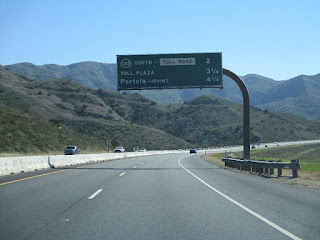
The current CA 241 was defined as part of 1988 Legislative Chapter 1363 as "Route 231 near the Cities of Tustin and Irvine to Route 5 south of San Clemente."  The planned corridor of the third CA 241 appears on the 1990 Caltrans Map.  


As originally defined the current CA 241 only included the Foothills Transportation Corridor of the Orange County Transportation Corridor System.  The Foothills Transportation Corridor is subdivided into the Foothill-North and Foothill-South segments.  The Foothill-North segment of the Foothills Transportation Corridor spans from the current junction of CA 133 south to Oso Parkway.  CA 241 between Portola Parkway in Irvine south to Antonio Parkway in Rancho Santa Margarita initially opened in two segments: a 3.2-mile segment on October 16th, 1993 and a 4.3-mile segment on April 7th, 1995.  

1996 Legislative Chapter 1154 extended CA 241 north via transfer from CA 231.  The new definition of CA 241 retained its southern terminus, but the northern terminus was reassigned as "Route 91 in the City of Anaheim.  The new segment of CA 241 north of CA 133 which was absorbed from CA 231 is the Eastern Transportation Corridor.  

According to AAroads the next segments of CA 241 to open came in 1998.  This included northernmost end of the Foothill-North segment to CA 133 in addition to the eastern Transportation Corridor north to CA 91.  CA 241 was extended south to Oso Parkway in 1999 which completed the Foothill-North segment.

Beginning in 2000 the process to select a planned alignment of CA 241 via the Foothill-South segment to Interstate 5 began.  Attempts to extend CA 241 south to Interstate 5 have met heavy resistance in the past two decades.   Development of CA 241 on the Foothill South segment was dealt a serious obstruction when Governor Gavin Newsom signed Assembly Bill Number 1426 on September 25th, 2020.  Assembly Bill Number 1426 effectively blocked CA 241 from being constructed to Interstate 5 at San Onofre State Beach.  


During April 2021 the City of San Clemente voted to pursue removing itself from TCA.  The vote by the City of San Clemente stemmed from two pieces of Legislation initiated by Patricia Bates.  One pieces of Legislation would have the definition of CA 241 truncated to Oso Parkway while the second would provide protections for open spaces within the City of San Clemente which could have been purposed for the Foothill South segment.  

CA 241 in its current form appears on the 2005 Caltrans Map.  


Part 2; a drive on California State Route 241

CA 241 southbound begins from westbound CA 91 Exit 41B in Anaheim. 


Since 2014 CA 241 has operated under electronic-only tolling via the FasTrak collection system.  


CA 241 south of CA 91 to CA 133 is part of the Eastern Transportation Corridor.  CA 241 southbound Exit 33 accesses Orange County Route S18/Santiago Canyon Road.  CA 241 southbound Exit 32 accesses CA 261.  


CA 241 southbound Exit 27 accesses CA 133. 


CA 241 south of CA 133 transitions onto the Foothill Transportation Corridor.  CA 241 southbound Exit 25 accesses Portola Parkway.  


CA 241 southbound Exit 23 accesses Alton Parkway.  


CA 241 southbound Exit 22B accesses Lake Forest Drive whereas Exit 22A accesses Portola Parkway.  CA 241 southbound Exit 20 accesses Los Alisos Boulevard, Exit 19 accesses Santa Margarita Parkway and Exit 18 accesses Antonio Parkway. 


CA 241 southbound terminates at Exit 14 at Oso Parkway.  Since this photo was taken by Dan Murphy traffic can continue south onto Los Patrones Parkway to Cow Camp Road near CA 74.  


CA 241 northbound begins on the Foothill Transportation Corridor at Oso Parkway.  


CA 241 northbound Exit 18 accesses Antonio Parkway.


CA 241 northbound Exit 19 accesses Santa Margarita Parkway. 


CA 241 northbound Exit 20 accesses Los Alisos Parkway. 


CA 241 northbound Exit 21 accesses Portola Parkway.


CA 241 northbound Exit 23 accesses Alton Parkway. 


CA 241 northbound Exit 25 accesses Portola Parkway.


CA 241 northbound Exit 27 accesses CA 133.  


CA 241 north of CA 133 transitions onto the Eastern Transportation Corridor.  CA 241 northbound Exit 33 accesses Orange County Route S18/Santiago Canyon Road.  CA 261 southbound traffic is directed to Exit onto Orange County Route S18. 


CA 241 continues to a northern terminus at CA 91. 


Part 3; Roadwaywiz on California State Route 241

During October 2020 Dan Murphy of the Roadwaywiz YouTube Channel and Gribblenation featured real-time drives on CA 241.  Below CA 241 can be viewed southbound from CA 91 to Oso Parkway.


Below CA 241 can be viewed from Oso Parkway north to CA 91. 


During May 2020 CA 133 was featured as part of the Roadwaywiz Los Angeles Webinar.  CA 241 along with the other Orange County Toll Roads are discussed by panelists Dan Murphy, Scott Onson and Steve Alps at 50:54-1:09:50.


Comments

Popular posts from this blog

Did Caltrans just kill the G26 cutout US Route shields?

The US Route System was formally created by the American Association of State Highway Officials during November 1926.  Through the history of the system the only state to which has elected to maintain cutout US Route shields has been California.  The G26 series cutout US Route shields have become a favorite in the road enthusiast hobby and are generally considered to be much more visually pleasing than the standard Federal Highway Administration variant.  However, the G26 shield series appears to have been killed off on January 18, 2026, when Caltrans updated their Manual of Uniform Traffic Control Devices.  This blog will examine the history of the US Route shield specifications in California and what is happening with the 2026 changes.  The blog cover photo is facing towards the terminus of California State Route 136 and at a G26-2 specification US Route 395 shield.  In the background Mount Whitney can be seen in the Sierra Nevada range.   ...

May 2023 Ontario Trip (Part 3 of 3)

  Over the years, I have made plenty of trips to Ontario, crisscrossing the southern, central and eastern parts of the province. Living in Upstate New York, it's pretty easy to visit our neighbor to the north, or is that our neighbor to the west? Ottawa is one of my favorite cities to visit anywhere in the world, plus I've discovered the charm of Kingston, the waterfalls of Hamilton (which is on the same Niagara Escarpment that brings us Niagara Falls), the sheer beauty of the Bruce Peninsula, and more. But I hadn't explored much of Cottage Country. So I decided to change that, and what better time to go than over Memorial Day weekend, when the daylight is long and I have an extra day to explore. On the third and final day of my trip, I started in Huntsville and made my way through Muskoka District and Haliburton County, passing by many lakes along the way. I stopped in towns such as Dorset, Haliburton and Bancroft before making a beeline down to Belleville and then over th...

Ghost Town Tuesday; Nichols, FL

A couple years ago I spent a lot of spare time exploring phosphate mining ghost towns in the Bone Valley of Polk County, Florida.  One ghost town in particular called Nichols on Polk County Route 676 west of Mulberry caught my eye due to a relative lack of documentation on ghosttowns.com. Nichols was created in 1905 during the early phosphate mining boom in the Bone Valley region.  For the time Nichols was unusual since it had company housing in the Nichols Mine site and private residences outside the gate.  Nichols is only about two miles west of Mulberry which probably made it a somewhat reasonable commute even by the wonky standards of the early 20th Century.  Most of the Bone Valley region was relatively remote which made commuting or homesteading impractical which is why there are so many ghost towns in the area.  The company housing section of Nichols was phased out and abandoned by 1950. The Nichols town site is largely abandoned and could "possibl...