Located on the Gunpowder River (also known as Little Gunpowder Falls) and surrounded by the Gunpowder Falls State Park, the historic
Jerusalem Mill Village began taking shape before Harford County, Maryland was established. Today, the village still includes a grist mill, the Miller’s House, blacksmith forge, tenant house, general store, Jerusalem Mansion, Bank Barn, springhouse, a two story smokehouse and dairy, along with a another residence. Jerusalem Mill was one of the important early mills in Harford County, and one of the largest in the State of Maryland. The
Jericho Covered Bridge is located adjacent to the village. All of the existing buildings were built in the 1700s or 1800s by the Lee family, owners of the Jerusalem Mill for over one hundred years, and have been preserved for history by a group called the Friends of Jerusalem Mill.
Jerusalem Mill itself was built between 1769 and 1772 by miller David Lee and millwright Isaiah Linton. It is the oldest and most impressive of Harford County’s historic mills, and was one of eighteen mills constructed by Isaiah Linton. While over 300 mill sites have been identified in Harford County, only a handful of the mills survive, and the Jerusalem Mill is the only extant mill along the Little Gunpowder Falls. A low lying site along the Fall Line on Little Gunpowder Falls called Jerusalem was selected as a mill seat. After completing the mill’s construction in August 1772, David Lee began milling flour under the "White Silk" label. Much of the gristmill’s flour was shipped down the Chesapeake on the way to the Caribbean. By 1814, the Jerusalem mill site had grown to include a saw mill, blacksmith and coopers shops, miller’s house, mill workers’ houses, general store, post office, and other support structures.
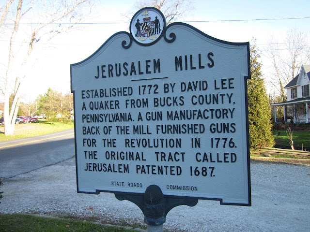
Originally known as Lee's Merchant Mill, Jerusalem Mill is also important as the centerpiece for one of the most complete mill villages in Maryland, and the only remaining example of an industrial complex within the Little Gunpowder Falls, which was among the state’s most prominent areas of early industrialization. David Lee’s mill village reflected the transformation that was occurring at the hands of early entrepreneurs during the Industrial Revolution. Numerous merchant mills were established in this area to take advantage of the growing flour export trade through the important port of Baltimore as well as the rise of grain production then replacing tobacco in importance as an agricultural commodity. Lee was a Quaker who came to Maryland from Bucks County. Pennsylvania, intentionally selecting a site along a river with ample power to support milling operations, with others following suit for similar reasons. This fostered many other industrial operations beyond milling that were also dependent on water power. As a result, the Little Gunpowder Falls featured prominently in the development of Maryland. The Jerusalem mill complex represents an early example of vertical integration as Lee’s operations included a tenant farmer who raised grain that was ground in the mill, and then was packed in barrels made on site through the sawmill and coopers shop for transport to distant markets.
Interestingly, Lee was a cousin to the Ellicott brothers, who founded the premier Maryland mill town at Ellicott Mills (later Ellicott City, just west of Baltimore) at about the same time. In fact, Lee traveled together with the Ellicotts to explore areas in Maryland conducive to the establishment of mill sites. Prior to establishing Jerusalem Mill, Lee apprenticed as a millwright. As a progressive agriculturalist, Lee convinced his neighbors of the value of grain over tobacco production and was among the first in the area to introduce fertilizers such as lime to replenish the soil. In 1816, the mill property was passed on to his son Ralph S. Lee, who produced cornmeal and flour. His son, David Lee II, took over in 1862. He diversified operations at the mill site to reintroduce a saw mill, as well as introducing a cider press and various retail operations. David Lee II was also instrumental in getting the nearby
Jericho Covered Bridge constructed in 1865. The mill property remained in the Lee family until 1886, continuing to operate under water power into the 20th Century. The mill was converted to electricity after a flood broke the dam in 1940. It ceased operations in 1961 with the death of its last miller, John Bridges.
Jerusalem Mill is an elegant and impressive example of the once numerous mill buildings of this region. It saw great changes in technology and economy through its two centuries of operation. The half mile long mill race channeled water into the mill and powered two internal pitch back waterwheels. These were later replaced by two horizontal water turbines, which turned the vertical shafts driving the machinery above. The ground floor served as the grinding level with 52 inch millstones. It is a massive, three-story, heavy timber frame structure, measuring 60 by 36 feet and set on a high stone basement 2 to 3 feet thick and is banked into the hillside. The frame exterior is covered by board and batten siding and the steeply pitched gable roof enabled a unique feature for the mill, allowing for two levels of dormer windows. A date stone located near the north entrance is inscribed "1772 – David Lee" and is surrounded by dressed stone. While the exterior remains intact, much of the interior framing and equipment date to the 19th Century. Still extant are the 2 foot square white oak posts supporting the corners of the building at each level, large oak beams, and posts held by joints pegged with large treenails. In addition to flour milling, barrel making, and blacksmithing, Lee manufactured gun stocks for the Maryland militia in a small stone building adjoining the mill.
Abandoned for years, a group called the Friends of Jerusalem Mill was formed in 1985, setting their sights on restoring all the buildings of the historic Jerusalem Mill Village. Fallen into a severe state of disrepair, the mill village of nearly a dozen main buildings offered the organization challenges. Recognized by the Preserve America Stewards Program, they have achieved great results preserving the grist mill, gun factory, blacksmith shop, general store and springhouse. It was later restored by the Maryland Department of Natural Resources as a public living history museum due to the efforts of the Friends of Jerusalem Mill and is now one of the oldest, most complete mill villages in Maryland. The Historic Jerusalem Mill Village, part of
Gunpowder Falls State Park, provides an opportunity to view and understand the workings of a self-sufficient mill village. In addition to the Jerusalem Mill, the twelve other buildings in the area include the stone miller’s house, gun shop, blacksmith shop, bank barn, tenant house, store, and other support buildings. The Miller’s House is a two story stone house with a large exterior stone chimney. The early 19th Century blacksmith shop is an example of a structure made of rubble stone that includes quoining at the corners. Lee’s stone mansion and the house built for his tenant farmer are also still standing just outside of the village proper.
Today, you can visit the historic
Jerusalem Mill village by walking around the grounds or visiting any of the buildings that are open to the public. The buildings that are open to the public are the grist mill (where the visitor center is located), blacksmith shop, springhouse, Miller's House and McCourtney's General Store. The Miller's House was once known as the gun shop, due to its for its alleged use during the American Revolutionary War for the production of gunstocks for the Maryland Militia. The McCourtney's General Store had its moment during the Civil War when a band of Confederate Cavalry under the command of Colonel Harry W. Gilmor swooped down and "requisitioned" nearly $1,000 worth of goods and horses. There are also some private residences that are around the Jerusalem Mill village that are understandably not open to the public.
 |
| A private residence that blends in well with the historic Jerusalem Mill Village. |
 |
| McCourtney's General Store. |
 |
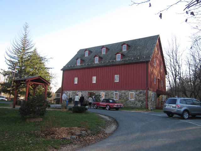
Bank Barn.
|
 |
| Historic grist mill and visitor's center. |
 |
| The historic Baltimore and Jerusalem Turnpike is now part of US 1, known locally as Belair Road. |
 |
| Historic millstone. |
 |
| Blacksmith Shop |
 |
| Grist mill and miller's house. |
 |
| Little Gunpowder Falls. |
 |
| Miller's House. |
 |
| There is a garden behind the Miller's House. But since it was December, the growing season was done. |
 |
| Side profile of the blacksmith shop. |
How to Get There (Jerusalem Mill):
Sources and Links:
Instagram - Jerusalem Mill Village
Maryland Historical Trust - Jerusalem Mill Village
Scenic USA - Maryland - Jerusalem Mill
Society of Architectural Historians - Jerusalem Mill
Visit Harford Maryland - Historic Jerusalem Mill Village
Enjoy Baltimore County Maryland - Historic Jerusalem Mill Village
Historic Jerusalem Mill Village - Welcome to the Historic Jerusalem Mill Village
Historic Jerusalem Mill Village - Photo Gallery
Maryland Department of Natural Resources - Gunpowder Falls State Park / Jerusalem Mill History




Comments