
Hawaii Route 95

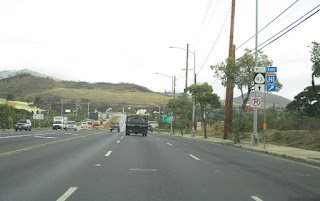
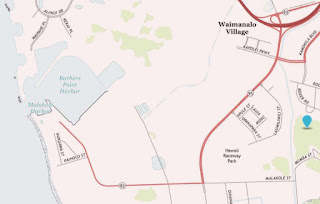
Hawaii Route 95 is an unsigned State Highway on the Island of O'ahu.  Hawaii Route 95 begins at Interstate H-1/Queen Liliuokalani Freeway Exit 1 near Makalio.  From Interstate H-1 the alignment Hawaii Route 95 follows Kalaeloa Boulevard 1.5 miles south and Makakole Street westward towards Barbers Point Harbor.  


This page is part of the Gribblenation Hawaii Roads series.  A compellation of all Hawaii-related media from both Gribblenation and RoadwayWiz can be found by clicking here


Part 1; the history Hawaii Route 95

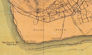
During October 1795 British Sea Captain Henry Barber was leading a trading voyage to China on the ship known as the Arthur.  After resupplying in Waikiki, the Arthur set sail westward for Kaua'i.  While rounding O'ahu the Arthur wrecked on a reef which led to the death of six of the crewmembers.  The remaining fifteen crew of the Arthur made it ashore at what came to be known as Barbers Point.  Barbers Point is known as Kalaeloa in Hawaiian and can be seen on the 1899 J.T. Taylor Map of O'ahu.

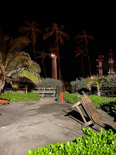
In 1888 a lighthouse was built at Barbers Point as a navigational aid.  The original Barbers Point Lighthouse was replaced by the current structure in 1933.  The second Barbers Point Lighthouse was automated in 1964 and is accessible from Barbers Point Beach Park. 

During World War II the territory of Hawaii saw an influx of military activity following the attack on Pearl Harbor on December 7th, 1941.  Numerous Military Routes and early Hawaii Routes were signed through the Hawaiian Territory to aid military personnel in navigating the islands.  Military Highways were assigned US Route style shields whereas lesser highways were assigned an early variation of what is now the Hawaii Route Spade.  A 1946 Army Map of the Island of O'ahu shows Hawaii Route 215 (following Camp Road) and Hawaii Route 214 over the general corridor of modern Hawaii Route 95 within the ranges of Naval Air Station Barbers Point.  Naval Air Station Barbers Point had been opened by the United States Navy during 1943.  A full version of the 1946 Army Map of O'ahu can be seen on hawaiihighways.com here.  


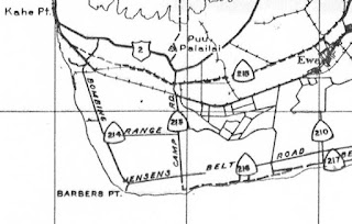
Circa 1955 following the conclusion of World War II the United States Bureau of Public Roads renumbered the Hawaii Route System.  The 1955 Hawaii Route renumbering saw most of the conventions utilized by the current Hawaii State Route System established.  Primary Hawaii Routes were given two digit numbers whereas Secondary Hawaii Routes were given three digit numbers.  The Hawaii Routes were assigned in sequence for what Island/County they were located on coupled with what Federal Aid Program number they were tied to.  In the case of O'ahu the Island was assigned numbers in the range of 60-99.  World War II era Hawaii Route 215 and Hawaii Route 214 were not given new 1955 era designations.  Barbers Point can be seen on the 1959 Gousha Map of Hawaii being accessible only via a military road from Naval Air Station Barbers Point.  


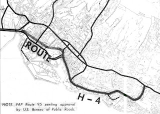
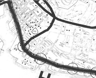
Conceptually Hawaii Route 95 was first proposed as a Federal Aid Primary Program in downtown Honolulu which can be seen in the Interstate H-4 proposal document titledProposed Route H-4.  The original Hawaii Route 95 proposal would have followed the general corridor of South Street north from proposed Interstate H-4 to Interstate H-1/Luanlilo Freeway.  


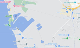
The Barbers Point Deep Draft Habor was completed by the United State Army Corps of Engineers during 1985 at a cost of $59,000,000 dollars.  Naval Air Station Barbers Point was closed during 1999 as part of the Base Realignment and Closure Acts of the 1990s.  Barbers Point Harbor was subsequently turned over to the State of Hawaii.  The transfer of Barbers Point Harbor saw it converted to commercial usage via which led to the emergence of the current Hawaii Route 95.  Hawaii Route 95 (Hawaii Route 93 is shown in error on Malakole Street) can be seen on the 2013 USGS Map of Barbers Point.


Part 2; a drive on Hawaii Route 95

Below Hawaii Route 95 can be seen headed eastbound via Kalaeloa Boulevard from Malakole Street to Interstate H-1/Queen Liliuokalani Freeway.


During May of 2019 Dan Murphy of the Roadwaywiz Channel and Gribblenation featured real-time drives on Hawaii Route 95.  Below Hawaii Route 95 can be viewed westbound. 


Below Hawaii Route 95 can be viewed eastbound.


Comments

Popular posts from this blog

Did Caltrans just kill the G26 cutout US Route shields?

The US Route System was formally created by the American Association of State Highway Officials during November 1926.  Through the history of the system the only state to which has elected to maintain cutout US Route shields has been California.  The G26 series cutout US Route shields have become a favorite in the road enthusiast hobby and are generally considered to be much more visually pleasing than the standard Federal Highway Administration variant.  However, the G26 shield series appears to have been killed off on January 18, 2026, when Caltrans updated their Manual of Uniform Traffic Control Devices.  This blog will examine the history of the US Route shield specifications in California and what is happening with the 2026 changes.  The blog cover photo is facing towards the terminus of California State Route 136 and at a G26-2 specification US Route 395 shield.  In the background Mount Whitney can be seen in the Sierra Nevada range.   ...

May 2023 Ontario Trip (Part 3 of 3)

  Over the years, I have made plenty of trips to Ontario, crisscrossing the southern, central and eastern parts of the province. Living in Upstate New York, it's pretty easy to visit our neighbor to the north, or is that our neighbor to the west? Ottawa is one of my favorite cities to visit anywhere in the world, plus I've discovered the charm of Kingston, the waterfalls of Hamilton (which is on the same Niagara Escarpment that brings us Niagara Falls), the sheer beauty of the Bruce Peninsula, and more. But I hadn't explored much of Cottage Country. So I decided to change that, and what better time to go than over Memorial Day weekend, when the daylight is long and I have an extra day to explore. On the third and final day of my trip, I started in Huntsville and made my way through Muskoka District and Haliburton County, passing by many lakes along the way. I stopped in towns such as Dorset, Haliburton and Bancroft before making a beeline down to Belleville and then over th...

Ghost Town Tuesday; Nichols, FL

A couple years ago I spent a lot of spare time exploring phosphate mining ghost towns in the Bone Valley of Polk County, Florida.  One ghost town in particular called Nichols on Polk County Route 676 west of Mulberry caught my eye due to a relative lack of documentation on ghosttowns.com. Nichols was created in 1905 during the early phosphate mining boom in the Bone Valley region.  For the time Nichols was unusual since it had company housing in the Nichols Mine site and private residences outside the gate.  Nichols is only about two miles west of Mulberry which probably made it a somewhat reasonable commute even by the wonky standards of the early 20th Century.  Most of the Bone Valley region was relatively remote which made commuting or homesteading impractical which is why there are so many ghost towns in the area.  The company housing section of Nichols was phased out and abandoned by 1950. The Nichols town site is largely abandoned and could "possibl...