US Route 20 eastbound from Idaho Falls crosses the Montana State Line via Targhee Pass. Targhee Pass is a corridor historically linked to US Route 191 and has always been part of the alignment of US Route 20 upon it's extension west of Yellowstone National Park in 1940.

Part 1; the history of the US Route System over Targhee Pass
Targhee Pass is a 7,072 foot high mountain pass located in the Henry Lake Mountains (part of the Rocky Mountains) of Targhee National Forest. Targhee Pass is part of the Continental Divide and marks the boundary of the Idaho/Montana State Line. Historically Targhee Pass is most well known for the Nez Perce War during which Chief Joseph utilized the pass circa 1877 to evade the U.S. Cavalry.
The Henry Lake Mountains became relevant as a modern transportation corridor when West Yellowstone was plotted by the Oregon Short Line Railroad as it's eastern terminus during November of 1907. The Oregon Short Line Railroad subsequently completed it's line to West Yellowstone by June of 1908. The rail terminus of the Oregon Short Line Railroad in West Yellowstone was the head of a stage road via the Madison River into Yellowstone National Park. The Oregon Short Line Railroad bypassed Targhee Pass for the more favorable grades of nearby Reas Pass located southeast of modern US Route 20 ("US 20"). The Oregon Short Line Railroad can be seen terminating in West Yellowstone on the 1912 Rand McNally Map of Montana.

During the emergence of the automobile the Oregon Short Line Railroad was supplemented by a highway over Targhee Pass. The 1924 Rand McNally Map of Montana, Wyoming, Colorado, Idaho, Utah and Nevada shows the Banff-Grand Canyon National Highway and Salt Lake-Yellowstone Highway aligned over Targhee Pass.
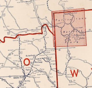
The US Route System was created on November 11th, 1926 as a replacement for the preexisting Auto Trails. US 191 was selected to be aligned from the western entrance of Yellowstone National Park towards Idaho Falls via Targhee Pass. The 1927 National Company Map displays US 191 utilizing Targhee Pass and terminating at West Yellowstone via Idaho State Route 29.
US 191was extended north from West Yellowstone to Bozeman circa 1934. The extension of US 191 towards Bozeman left no US Route reaching the western entrance of Yellowstone National Park. US 191 can be seen on the 1937 Gousha Map of Idaho extending north of West Yellowstone through the Gallatin Mountains.
On October 30th, 1940 Idaho Department of Public Works acknowledged in a letter to the AASHO that US 20 had been extended through West Yellowstone via multiplex of US 191 to Sugar City. The AASHO description of US 20 had it jog west via Idaho State Route 28 to Sage Junction to reach US 91. The Idaho Department of Public Works requested US 20 be clarified to multiplex US 191 to Blackfoot (through Idaho Falls) to reach US 91 due to Idaho State Route 28 not being constructed to Sage Junction.
1944 State Farm Map of Idaho shows US 20/US 191 multiplexing from West Yellowstone to US 91 in Idaho Falls.
The truncation of US 191 from Idaho Falls to US 287 north of West Yellowstone was approved by the AASHTO Executive Committee on during October 1978. This left US 20 as the only highway aligned from West Yellowstone west over Targhee Pass to Idaho Falls.
The extension of US 191 from US 287 near West Yellowstone to Interstate 40 in Chambers, AZ was approved by the AASHTO Executive Committee during June of 1981. This extension of US 191 saw it multiplex US 20/US 287 through West Yellowstone to the west entrance of Yellowstone National Park.
Part 2; a drive on US Route 20 over Targhee Pass to the western entrance of Yellowstone National Park via West Yellowstone
As US 20 eastbound crosses the Henrys Fork River in Ashton County, Idaho it begins a climb into the Henry Lake Mountains and enters Targhee National Forest.
US 20 eastbound follows the course of Henrys Fork River to a clearing in the Henry Lake Mountains. US 20 eastbound intersects Idaho State Route 87 which can be used to access the namesake Henrys Lake. Henrys Lake lies at an elevation of approximately 6,472 feet and covers a surface area of just over 9 square miles. Henrys Lake is the source of the Henrys Fork River which is part of the larger Snake River watershed.
US 20 east of Idaho State Route 87 is signed as part of the Nez Perce National Historic Trail. From Idaho State Route 87 the alignment of US 20 eastbound climbs to the 7,072 foot high Targhee Pass and enters Gallatin County, Montana. From the Idaho/Montana State Line at Targhee Pass US 20 eastbound is signed as 10 miles from West Yellowstone.
US 20 eastbound descends via the Targhee Pass Highway into the City of West Yellowstone. US 20 eastbound enters downtown West Yellowstone via Firehole Avenue and picks up US 191/US 287 southbound via a right hand turn onto Canyon Street. Traffic headed to Yellowstone National Park is directed to follow US 20 east via multiplex of US 191/US 287 south. The City of West Yellowstone lies at an elevation of 6,667 feet above sea level.
The multiplex of US 20/US 191/US 287 jogs south on Canyon Street in downtown West Yellowstone and makes a left hand turn onto Yellowstone Avenue to approach the west entrance of Yellowstone National Park.
The Oregon Short Line Railroad stopped operating passenger trains to West Yellowstone circa 1960 due to declining ridership. The Union Pacific Railroad subsequently deeded the Oregon Short Line buildings to the City of West Yellowstone after it incorporated on June 6th, 1966. The West Yellowstone Oregon Short Line Terminus Historic District was added to the National Register of Historic Places during 1983. The Oregon Short Line Railroad Depot located on Yellowstone Avenue was constructed during 1909.


US 20/US 191/US 287 follow Yellowstone Avenue east to the City Limit of West Yellowstone where they terminate at the boundary of Yellowstone National Park. The West Entrance Road of Yellowstone National Park follows the Madison River eastward over the Wyoming State Line to Madison Junction at the Grand Loop Road. No implied through route for US 20, US 191 and US 287 exists within Yellowstone National Park. US 20 resumes at the eastern entrance of Yellowstone National Park via a multiplex of US 14. US 191 and US 287 resume along with US 89 via branching paths at Moran Junction of Grand Teton National Park south of Yellowstone National Park.




Comments