
The Putah Creek Bridge of Monticello (former California State Route 28)

The Putah Creek Bridge was a masonry structure constructed during 1896 by Napa County to serve the community of Monticello.  The Putah Creek Bridge would be annexed into the State Highway System in 1933 when Legislative Route Number 6 was extended from Woodland Junction to Napa.  The Putah Creek Bridge was a component of the original California State Route 28 from 1934-1952.  The span briefly became part of California State Route 128 in 1953 until the highway was relocated as part of the Monticello Dam project in 1955.  Today the Putah Creek Bridge sits at the bottom of the Lake Berryessa reservoir and is accessible to divers.  Pictured as the blog cover is the Putah Creek Bridge as it was featured in the September 1950 California Highways & Public Works.  

California State Route 28 can be seen crossing the Putah Creek Bridge near Monticello on the 1943 United States Geological Survey map of Copay.  


The history of the Putah Creek Bridge

The site of Monticello lies under the waters of the Lake Berryessa reservoir in what was once known as Berryessa Valley.  The Berryessa Valley name is derived from the Berryessa family which was granted the lands of Rancho Las Putas by Mexican Governor Manual Micheltorena during 1843.  The Berryessa sold their stake in Rancho Las Putas to American investors during 1853.  

Rancho Las Putas was subdivided during 1866 and the farming community of Montecillo was plotted.  By 1870 a franchise wagon road from Napa was constructed via a new bridge over Putah Creek.  By 1875 Napa County purchased the road connecting Napa-Monticello and declared it a public highway.  The highway connecting Napa-Monticello can be seen on the 1882 Bancroft's Map of California.  

The history of the Putah Creek Bridge was featured in the September 1950 California Highways & Public Works Centennial Edition.  The Putah Creek Bridge was referenced in the issue as being a notable example of a masonry bridge in the State Highway System (then part of California State Route 28 and Legislative Route Number 6).  The Putah Creek Bridge was constructed during 1896 by Napa County. The structure was cut from native sourced sandstone and was 70 feet long. The article notes the Putah Creek Bridge was subject to being inundated if the construction of Monticello Dam proceeded.


During 1933 Legislative Route Number 6 (LRN 6) was extended from Woodland Junction to Napa by way of Monticello. The extension of LRN 6 annexed the Putah Creek Bridge into the State Highway System.
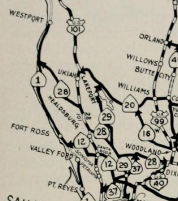
The initial run of Sign State Routes was announced in the August 1934 California Highways & Public Works.   The Putah Creek Bridge was assigned as a component of the original California State Route 28 which utilized LRN 6 in the Monticello area.  


California State Route 28/LRN 6 can be seen crossing the Putah Creek Bridge near Monticello on the 1935 Division of Highways Map of Napa County.  

California State Route 28/LRN 6 can be seen crossing the Putah Creek Bridge near Monticello on the 1943 United States Geological Survey map of Copay.  


The May/June 1953 California Highways & Public Works announced that California State Route 28 was redesignated as California State Route 128.  The California State Route 28 designation was moved to the north shore of Lake Tahoe to be continuous with the long existing Nevada State Route 28.  


The March/April 1955 California Highways & Public Works depicts the progress of the realignment of California State Route 128/LRN 6 at the site of the 270-foot-high Monticello Dam.  The Monticello Dam project broke ground in 1953 along Putah Creek with the end goal of creating the Lake Berryessa Reservoir.  The construction of Monticello Dam required both California State Route 37 and California State Route 128 be realigned to the south of the planned Lake Berryessa.   California State Route 128/LRN 6 in particular was heavily impacted by the Monticello Dam project as it followed Putah Creek from the outskirts of the Town of Monticello east to the Yolo County Line.  Additionally, the Town of Monticello in Berryessa Valley was slated to be inundated by 100 feet of water.  In total 16.3 miles of new highway was slated to be constructed which was largely comprised of a realigned California State Route 128.  The realigned California State Route 128 would make a brief swing into Solano County near the site of Monticello Dam.   Monticello Dam was topped out during November of 1957, but Lake Berryessa wouldn't fill to capacity until April of 1963.


The newly realigned California State Route 128/LRN 6 south of the planned Lake Berryessa appears on the 1956 Division of Highways State Map.  


The former site of Monticello and location of Putah Creek can be seen on the 1959 United State Geological Survey map of Lake Berryessa.  The Putah Creek Bridge was not demolished during the Monticello Dam project and generally is located 100 feet beneath the waters of Lake Berryessa.  


The Putah Creek Bridge has become a well-known dive site at Lake Berryessa.  Underwater footage from the Putah Creek Bridge can be seen below as it was presented on YouTube in 2011.  

Comments

Popular posts from this blog

Grand Loop Road of Yellowstone National Park

  Grand Loop Road is a 140 mile loop highway which traverses the interior of Yellowstone National Park.  Grand Loop Road connects all of the major attractions and geological features of Yellowstone National Park along with the entrance roads.  Grand Loop Road is a seasonal highway and despite some conjecture never has been part of the US Route System.   Part 1; the history of Grand Loop Road The majority of history pertaining to Grand Loop Road was taken from the below National Park Service article: Historic Roads - Yellowstone National Park (U.S. National Park Service) (nps.gov) Yellowstone was declared the first National Park of the United States on March 1st, 1872.  The first real highway to access Yellowstone National Park came in 1873 when a tolled facility was constructed from Bozeman, Montana via Yankee Jim Canyon to Mammoth Hot Springs.  Numerous attempts were made to fund construction of roadway infrastructure during the early years of Yellows...

The last 1956-63 era California Sign State Route Spade?

Along southbound California State Route 170 (the Hollywood Freeway Extension) approaching the Hollywood Freeway/Ventura Freeway interchange a white California State Route 134 Sign State Route Spade can be observed on guide sign.  These white spades were specifically used during the 1956-63 era and have become increasingly rare.  This blog is intended to serve as a brief history of the Sign State Route Spade.  We also ask you as the reader, is this last 1956-63 era Sign State Route Spade or do you know of others?  Part 1; the history of the California Sign State Route Spade Prior to the Sign State Route System, the US Route System and the Auto Trails were the only highways in California signed with reassurance markers.  The creation of the US Route System by the American Association of State Highway Officials during November 1926 brought a system of standardized reassurance shields to major highways in California.  Early efforts to create a Sign State Route ...

California State Route 70; the Feather River Highway

From 2017 through to early 2019 I drove the majority of the California State Route 70; the Feather River Highway from CA 89 southwest to CA 99. CA 70 is an approximately 178.5 mile state highway which starts at US 395 near the Nevada State Line and travels west through the Feather River Canyon to CA 99.  CA 70 is often referred to as the Feather River Highway" given it's close association with the river.  Historically CA 70 was previously signed as US 40A and CA 24.  The Legislative Routes prior to the 1964 California Highway Renumbering that made up the current route of CA 70 are as follows: -  Legislative Route Number 21 from US 395 westward to Oroville. -  LRN 87 from Oroville south to Marysville. -  LRN 232 from Marysville to the current junction with CA 99.  CA 70 was even dual signed with CA 99 into Sacramento on what was LRN 232 for a time. The change from US 40A/LRN 21/LRN 87/LRN 232 can be seen by comparing the 1963 State Highway Ma...