
East of Lemon Cove of Tulare County one can find several old alignments of California State Route 198 at the bottom of the Lake Kaweah Reservoir. In particularly dry years these early alignments of California State Route 198 can be accessed as hiking trails.
Part 1; a brief history of California State Route 198 in the Lake Kaweah Reservoir
The current corridor of California State Route 198 ("CA 198") in Lake Kaweah has a lengthy history. The present corridor around Lake Kaweah first became a popular route of travel for European settlers during the mining boom of Mineral King Valley. Through the 1860s prospectors arrived in Mineral King Valley by way of the Kaweah River and East Fork Kaweah River. In 1870 John Lovelace and his family built a stock trail up to what was known as Milk Ranch on the East Fork Kaweah River. The Lovelace extended their trail all the way up to Mineral King Valley and the prospector camp sites. In 1871 the stock trail was greatly improved and by 1872 the Lovelace family was driving cattle into Mineral King Valley. These early stock trails were the genesis point of what would become Mineral King Road and future CA 198.
The future of corridor of CA 198 through what is now Lake Kaweah saw increased usage upon the emergence of the Kaweah Colony. In 1886 the Kaweah Colony was established along the North Fork Kaweah River. The Kaweah Colony's economy was based on logging which led to the construction of the first 18 miles of what was known as the Colony Mill Road. The Colony Mill Road and Kaweah Colony sought to harvest timber from the Redwood Sequoia Trees of the Giant Forest. The alarm raised by conservationists at the prospect of the Kaweah Colony harvesting the Giant Forest played a large part in the creation of Sequoia National Park in September of 1890. In October of 1890 General Grant National Park was created to the north around the Grant Grove of Giant Redwood Sequoias. In 1903 the Colony Mill Road was extended by 8 miles into the Giant Forest by the U.S. Army to facilitate wagon travel into Sequoia National Park.
The existing road east of Visalia to Mineral King Road and the Colony Mill Road can be seen on the 1917 California State Automobile Association Map.

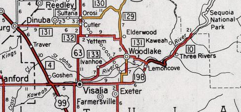
During the 1919 Third State Highway Bond Act Legislative Route Number 10 ("LRN 10") was extended east from Visalia to the Colony Mill Road of Sequoia National Park by way of the existing road along the Kaweah River. This early alignment of LRN 10 can be seen on the 1920 Division of Highways State Highway Map.

The March 1932 California Highways & Public Works details the announcement of a new highway alignment up for bid along LRN 10 from Lemon Cove to Three Rivers. This new alignment of LRN 10 is cited to be 8.5 miles in length and would shorten the existing highway by 1.1 miles but way of eliminating unnecessary curves.

The September/October 1932 California Highways & Public Works shows the LRN 10 Lemon Cove-Three Rivers realignment project awarded in September of 1932.

CA 198 was one of the original Sign State Highways which was announced in the August 1934 California Highways & Public Works. CA 198 was aligned entirely over Legislative Route 10.
Originally CA 198 was the highest number assigned to any Sign State
Highway.

A early CA 198/LRN 10 from Lemon Cove east to Three Rivers via what is now Lake Kaweah can be observed on the 1935 California Division of Highways Map of Tulare County. Notably; Terminus can be seen near the future site of the Terminus Dam on the Kaweah River. Terminus was a small rail community plotted out in 1908 as the eastern terminus of a Visalia Electric Railroad. Notably; this map shows CA 198/LRN 10 streamlined and shortened between Lemon Cove-Three Rivers as described in the 1932 Highway Project Bid. It is unclear when the Lemon Cove-Three Rivers realignment project was completed as it is not covered in a California Highways & Public Works. That said; the original alignment of LRN 10 between Lemon Cove-Three Rivers does not appear to have ever been part of CA 198.

The Terminus Dam was authorized a Army Corps of Engineers project as part of the Flood Control Act of 1944. In 1948 as plans for the Terminus Dam were being finalized when a archaeological survey determined the Kaweah River was rich in local tribal artifacts. Excavations by National Park Service Interagency Archaeological Salvage Program delayed the start of the Terminus Dam project until the late 1950s. The National Park Service published an article on NPS.gov (last updated in 2008) which details much of the cultural findings along the Kaweah River.
The March/April 1960 California Highways & Public Works cites that the relocation of CA 198 was halted due to the finding of a tribal dwelling and burial site. The remains/artifacts found during excavation were cited to be from the Western Mono and Yokut tribes.

East of Lemon Cove CA 198 was realigned uphill at some point in
1961/1962 due to
the construction of the Terminus Dam and opening of the Lake Kaweah
Reservoir. The realignment of CA 198 is not covered in any California
Highways & Public Works as it seems to have been overshadowed by
projects like the San Luis Reservoir and Lake Oroville. The Terminus
Dam was dedicated on May 18th, 1962 along with the Success Dam on CA
190. The new highway alignment of CA 198 south of the Terminus Dam site
can be seen on the 1962 Division of Highways State Map.
The Terminus Dam shortly after it's completion.

Part 2; mapping former California State Route 198 and the original Legislative Route Number 10 in Lake Kaweah
The customer map below was created using the above 1935 Division of Highways Map of Tulare County along with USGS Topographical Maps to chart the alignments of California State Route 198 and Legislative Route Number 10 at the bottom of the Lake Kaweah Reservoir. The red line represents the original alignment of California State Route 198 whereas the blue line represents the previous alignment of Legislative Route Number 10. Important locations are listed and marked the applicable colors.

Part 3; hiking former California State Route 198 and Legislative Route Number 10 at the bottom of Lake Kaweah
During dry years both the original alignments of CA 198 and LRN 10 can be accessed from the modern highway via the Slide Rock Recreation Area. This west facing view looks at the older alignment of CA 198 on the right whereas the modern highway can be seen on the left.

The older alignment of CA 198 descends westward towards the Kaweah River. During wet seasons this former segment of CA 198 often is underwater. A locked gate prevents vehicle access to the bottom of the Lake Kaweah Reservoir.


The locked gate sits above an embankment grade which was once part of CA 198. One can glimpse at how the Kaweah River used to look before it drained into the Lake Kaweah Reservoir.


Continuing west on foot beyond the locked gate reveals an early rock retaining wall.


Continuing west reveals a fork in the road. The right road is the original alignment of CA 198 whereas the left road is the original alignment of LRN 10.


Following the left road onto the original LRN 10 reveals concrete slabs which were common on State Highways during the First-Third State Highway Bond Act era. The concrete road by estimation is approximately 15 feet wide.


The original alignment of LRN 10 is at a higher elevation compared to it's CA 198 replacement. The concrete grade is covered with a light layer of dirt and sand but is very easy to spot. The alignment of LRN 10 swings southwest towards Horse Creek.


At Horse Creek an intact highway bridge can be found This particular bridge is very low and doesn't match any early Division of Highways design I'm aware of. I don't have any background information regarding this structure but I suspect it was built by Tulare County before LRN 10 west extended to the Colony Mill Road.


Returning to the road fork I took the right hand path onto the original alignment of CA 198.

Heading west the original alignment of CA 198 at higher elevation has asphalt that is easy to spot along with faint traces of a white center line. As the original alignment of CA 198 loses elevation approaching the Kaweah River and the asphalt becomes covered by a deep layer of dirt.


The original alignment of CA 198 is barely recognizable as a highway as it descends westward to Horse Creek.


The bridge which used to carry CA 198 over Horse Creek can be found where the older alignment of LRN 10 merged back into the newer alignment. There is a thick layer of dirt covering the CA 198 bridge at Horse Creek and there are no obvious identifying markers.


From modern CA 198 the original grade of CA 198 can be seen at the confluence of Lake Kaweah and Horse Creek looking east from road bend.

Part 4; former California State Route 198 at the Limekiln Hill spur of the Terminus Dam
Moving west to the Limekiln Hill spur of the Terminus Dam one can view the original alignment and grade of CA 198 by looking west from the Lake Kaweah visitor center at Lemon Hill. The original alignment of LRN 10 can be found west of the dam spur on Limekiln Hill and former CA 198 can be found in the former of Long Drive.

Comments