Former US Route 99 in Imperial

The city of Imperial lies within the Sonoran Desert of Imperial County and once was part of the alignment of US Route 99.  US Route 99 originally was aligned on Imperial Avenue through the city of Imperial.  US Route 99 was realigned immediately east of Imperial Avenue onto a bypass expressway during 1950.  US Route 99 would in Imperial would be replaced by California State Route 86 during 1963 when the former was truncated to downtown Los Angeles.  The blog cover depicts the original alignment of US Route 99 along Imperial Avenue in the city of Imperial during 1940.  US Route 99 can be seen passing through Imperial via Imperial Avenue on the 1935 Division of Highways Map of Imperial County.  


This blog is part of the larger Gribblenation US Route 99 Page.  For more information pertaining to the other various segments of US Route 99 and it's three-digit child routes check out the link the below.


The history of US Route 99 in Imperial

The town of Imperial was plotted during 1902 by the Imperial Land Company and named by engineer George Chaffey.  The Imperial Land Company was responsible for the development of numerous communities in Imperial Valley which lies in the Sonoran Desert south of the Salton Sea.  Imperial incorporated as a city on July 12, 1904 and was in the running to become the first Imperial County Seat.  Imperial would ultimately lose the County Seat to nearby El Centro when Imperial County was created out of eastern San Diego County on August 7, 1907.  

What would become US Route 99 through Imperial was added to the State Highway System as part of the 1916 Second State Highway Bond Act in the form of Legislative Route Number 26 (LRN 26).  The initial definition of LRN 26 originated in San Bernardino and terminated in El Centro.  The extension of LRN 26 through Imperial is referenced in the 1916 California Highway Bulletin


LRN 26 appears as a planned highway through Imperial on the 1918 California Highway Commission map.


The 1924 Rand McNally Map of California reveals LRN 26 through Imperial was not part of any major Auto Trails.  The alignment of LRN 26 through Imperial appears to be aligned Imperial Avenue. 

The initial draft of the US Route System was approved by the Secretary of Agriculture during November of 1925.  The US Route System within California was approved by California Highway Commission (CHC) with no changes recommended which can be seen in January 1926 California Highways & Public Works.  US Route 99 is shown departing San Bernardino via LRN 26 towards El Centro via Imperial.  


Thusly planned US Route 99 appears on the 1925 Rand McNally Map of California following LRN 26 through Imperial.  


The May 1925 California Highways & Public Works referenced LRN 26 from Brawley towards Imperial as being in an active grading contract.  


The March 1926 California Highways & Public Works noted the grading of LRN 26 between Brawley and Imperial had been recently completed with macadam surfacing.  


The US Route System was formally approved by the American Association of State Highway Engineers (AASHO) on November 11th, 1926. which formally brought US Route 99 into existence on LRN 26 through Imperial. 


The January 1928 California Highways & Public Works references an upcoming surfacing and oil project along US Route 99/LRN 26 between Brawley-El Centro. 


The September/October 1928 California Highways & Public Works noted the paving of US Route 99/LRN 26 between Brawley-El Centro had been budgeted during the September California Highway Commission meeting. 

US Route 99/LRN 26 can be seen passing through Imperial via Imperial Avenue on the 1935 Division of Highways Map of Imperial County.  
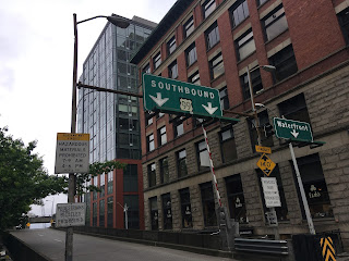

The original alignment of US Route 99 along Imperial Avenue in the city of Imperial during 1940 can be observed in the postcard below.  


The repaving of US Route 99/LRN 26 between Brawley-El Centro is cited in the July/August 1946 California Highways & Public Works as being approved as a post-World War II project.  The repaving project in the Brawley-El Centro corridor included new bridging structures. 


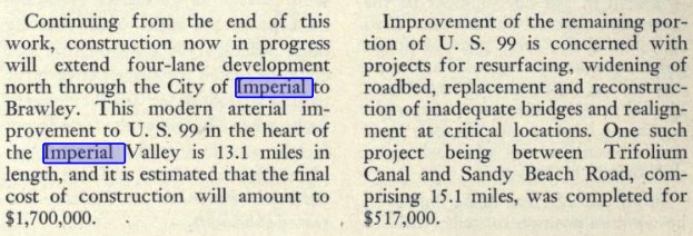
The November/December 1948 California Highways & Public Works references US Route 99/LRN 26 in El Centro having been recently expanded to four lanes.  The article stub notes that a continuation project would expand US Route 99/LRN 26 to four lanes in Imperial north to Brawley.


The May/June 1951 California Highways & Public Works discusses the effects of US Route 99/LRN 26 being rerouted off Imperial Avenue in Imperial onto a new expressway bypass.  The bypass realignment of US Route 99/LRN 26 in Imperial is stated to have opened during 1950 and was compared to the similarly sized city of Folsom.  


The truncation of US Route 99 from Calexico to the junction of the Golden State Freeway and San Bernardino Freeway in Los Angeles was approved by the AASHO Executive Committee on June 19th, 1963.  The justification by the California Division of Highways to truncate US Route 99 was to avoid what the agency viewed as confusing multiplexes on the new Interstate corridors of Southern California.  The truncation of US Route 99 did not take effect until New Year's Day 1964 and was part of the run up to the 1964 State Highway Renumbering.


During the 1964 State Highway Renumbering numerous changes were made to the State Highway System.  All the Legislative Route Numbers were dropped in favor of highway designations matching field signage.  The former corridor of US Route 99 from Indio to El Centro by way of Imperial was subsequently replaced with California State Route 86.  California State Route 86 through Imperial first appears on the 1964 Division of Highways Map.  


On October 9, 2013, Senate Bill 788, permitted the relinquishment of California State Route 86 within the cities of El Centro, Imperial and Brawley.  During December 2016 the California Transportation commission authorized the relinquishment of California State Route 86 within the city of Imperial. 


Further Reading

Continuing north on US Route 99 to Brawley?


Continuing south on US Route 99 to El Centro? 

Comments

Popular posts from this blog

Grand Loop Road of Yellowstone National Park

  Grand Loop Road is a 140 mile loop highway which traverses the interior of Yellowstone National Park.  Grand Loop Road connects all of the major attractions and geological features of Yellowstone National Park along with the entrance roads.  Grand Loop Road is a seasonal highway and despite some conjecture never has been part of the US Route System.   Part 1; the history of Grand Loop Road The majority of history pertaining to Grand Loop Road was taken from the below National Park Service article: Historic Roads - Yellowstone National Park (U.S. National Park Service) (nps.gov) Yellowstone was declared the first National Park of the United States on March 1st, 1872.  The first real highway to access Yellowstone National Park came in 1873 when a tolled facility was constructed from Bozeman, Montana via Yankee Jim Canyon to Mammoth Hot Springs.  Numerous attempts were made to fund construction of roadway infrastructure during the early years of Yellows...

The last 1956-63 era California Sign State Route Spade?

Along southbound California State Route 170 (the Hollywood Freeway Extension) approaching the Hollywood Freeway/Ventura Freeway interchange a white California State Route 134 Sign State Route Spade can be observed on guide sign.  These white spades were specifically used during the 1956-63 era and have become increasingly rare.  This blog is intended to serve as a brief history of the Sign State Route Spade.  We also ask you as the reader, is this last 1956-63 era Sign State Route Spade or do you know of others?  Part 1; the history of the California Sign State Route Spade Prior to the Sign State Route System, the US Route System and the Auto Trails were the only highways in California signed with reassurance markers.  The creation of the US Route System by the American Association of State Highway Officials during November 1926 brought a system of standardized reassurance shields to major highways in California.  Early efforts to create a Sign State Route ...

California State Route 70; the Feather River Highway

From 2017 through to early 2019 I drove the majority of the California State Route 70; the Feather River Highway from CA 89 southwest to CA 99. CA 70 is an approximately 178.5 mile state highway which starts at US 395 near the Nevada State Line and travels west through the Feather River Canyon to CA 99.  CA 70 is often referred to as the Feather River Highway" given it's close association with the river.  Historically CA 70 was previously signed as US 40A and CA 24.  The Legislative Routes prior to the 1964 California Highway Renumbering that made up the current route of CA 70 are as follows: -  Legislative Route Number 21 from US 395 westward to Oroville. -  LRN 87 from Oroville south to Marysville. -  LRN 232 from Marysville to the current junction with CA 99.  CA 70 was even dual signed with CA 99 into Sacramento on what was LRN 232 for a time. The change from US 40A/LRN 21/LRN 87/LRN 232 can be seen by comparing the 1963 State Highway Ma...