Back in 2012 I visited Organ Pipe Cactus National Monument in western Pima County for a winter hike in the Sonoyta Mountains. Organ Pipe Cactus National Monument is located directly north of the border with Sonora, Mexico and is generally traversed by Arizona State Route 85.

Organ Pipe Cactus National Monument was created in 1937 and is the only place in the United States where the Organ Pipe Cactus grows.


The land that Organ Pipe Cactus National Monument lies on was donated to the Federal Government during prohibition by the Arizona State Legislature with hopes the Federal Government would improve it. The land Organ Pipe National Monument was a traditional Spanish route travel known as the El Camino del Diablo (The Road of the Devil) between Caborca in Sonora 250 miles northwest to Yuma Crossing at the Colorado River into California.
El Camino del Diablo dates over 1,000 years as tribal route and likely was used by the Spanish Coronado Expedition in 1540 to cross the Sonoran Desert. The Spanish were guided to the Colorado River by local tribes who previously used El Camino del Diablo as a crossing of the Sonoran Desert during the winter months. El Camino del Diablo was an ideal crossing of the Sonoran Desert due to various natural wells that were located on the route. The first confirmed Spanish use of El Camino del Diablo was in 1699.
El Camino del Diablo largely fell into disuse after Quechan uprising along the Colorado River at Yuma Crossing in 1781. Fort Yuma was built in 1848 to protect travelers crossing into California. Coupled with the onset of the California Gold Rush of 1849 the route of El Camino del Diablo became a popular crossing of the Sonoran Desert to reach California. In 1853 the Gadsden Purchase was completed which ceded much of the Mexican lands south of the Gila River to the United States. This act placed the El Camino del Diablo north of Sonoyta within the U.S. territory of New Mexico which later became part of Arizona Territory in 1863. In the 1860s placer mining claims along the Colorado River near Fort Yuma increased traffic on El Camino del Diablo. When the Southern Pacific Railroad reached Yuma in 1877 El Camino del Diablo fell largely lost its popularity due to the dangers of crossing the Sonoran Desert presented.
El Camino del Diablo was a deadly route of travel with estimates stating that anywhere from 400 to 2,000 travelers have died trying to cross the Sonoran Desert. The well at Tinajas Atlas near the Gila Mountains is known to have 65 confirmed grave sites.
In modern context the route of El Camino del Diablo largely has been replaced from Mexican Federal Highway 2 between Caborca and Sonoyta in Sonora. On the Arizonan side El Camino del Diablo largely remains as it always has; a primitive ungraded dirt road crossing the Sonoran Desert. The route of El Camino del Diablo enters Arizona at Quitobaquito Springs in Organ Pipe Cactus National Monument and follows Pozo Nuevo Road northward to Cipriano Pass. In Growler Valley El Camino del Diablo swings westward out of Organ Pipe Cactus National Monument. The map of Organ Pipe Cactus National Monument below shows the route of El Camino del Diablo from the border near Quitobaquito Springs to the northwest.
Organ Pipe Cactus National Monument Park Map
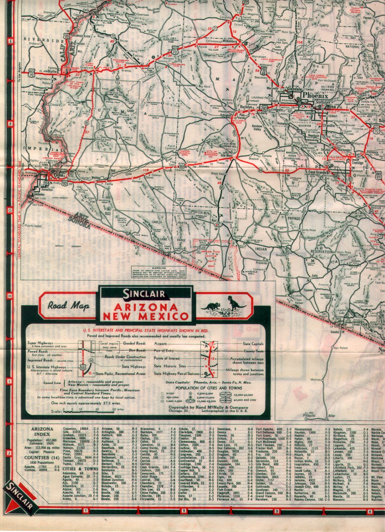
The route of the El Camino del Diablo continues west through what is now Cabeza Prieta National Wildlife Refuge and partially the Barry M. Goldwater Air Force Range to the Gila Mountains. The El Camino del Diablo crosses the Gila Mountains near the Mexican Border and emerges near Fortuna Foothills at County 14th Street. This 1938 Arizona Highway Map quadrant shows the El Camino del Diablo entering Arizona in Organ Pipe Cactus National Monument with a westward course to US 80 on the western flank of the Gila Mountains. The El Camino del Diablo can be identified by following; Bates Well, Papago Well, Tule Well, and the Fortuna Mine as way points.
1938 Arizona State Highway Map
Today the remaining portion of the El Camino del Diablo is most easily reached from AZ 85 south of Ajo via Darby Well Road south to Growler Valley in Organ Pipe Cactus National Monument. Back in the 2000s I did go out to parts of the El Camino del Diablo with some friends who had prepped four-wheel drive/high clearance vehicles. My word of caution is that this route is for season off-roaders and vehicles that can handle the terrain. Most publications advise carrying at minimum two spare tires along with enough water to last at least 7-10 days in the Sonoran Desert. These two publications offer more details on traveling the El Camino del Diablo.
desertusa.com on the El Camino del Diablo
azstateparks.com on the El Camino del Diablo

Organ Pipe Cactus National Monument was created in 1937 and is the only place in the United States where the Organ Pipe Cactus grows.


The land that Organ Pipe Cactus National Monument lies on was donated to the Federal Government during prohibition by the Arizona State Legislature with hopes the Federal Government would improve it. The land Organ Pipe National Monument was a traditional Spanish route travel known as the El Camino del Diablo (The Road of the Devil) between Caborca in Sonora 250 miles northwest to Yuma Crossing at the Colorado River into California.
El Camino del Diablo dates over 1,000 years as tribal route and likely was used by the Spanish Coronado Expedition in 1540 to cross the Sonoran Desert. The Spanish were guided to the Colorado River by local tribes who previously used El Camino del Diablo as a crossing of the Sonoran Desert during the winter months. El Camino del Diablo was an ideal crossing of the Sonoran Desert due to various natural wells that were located on the route. The first confirmed Spanish use of El Camino del Diablo was in 1699.
El Camino del Diablo largely fell into disuse after Quechan uprising along the Colorado River at Yuma Crossing in 1781. Fort Yuma was built in 1848 to protect travelers crossing into California. Coupled with the onset of the California Gold Rush of 1849 the route of El Camino del Diablo became a popular crossing of the Sonoran Desert to reach California. In 1853 the Gadsden Purchase was completed which ceded much of the Mexican lands south of the Gila River to the United States. This act placed the El Camino del Diablo north of Sonoyta within the U.S. territory of New Mexico which later became part of Arizona Territory in 1863. In the 1860s placer mining claims along the Colorado River near Fort Yuma increased traffic on El Camino del Diablo. When the Southern Pacific Railroad reached Yuma in 1877 El Camino del Diablo fell largely lost its popularity due to the dangers of crossing the Sonoran Desert presented.
El Camino del Diablo was a deadly route of travel with estimates stating that anywhere from 400 to 2,000 travelers have died trying to cross the Sonoran Desert. The well at Tinajas Atlas near the Gila Mountains is known to have 65 confirmed grave sites.
In modern context the route of El Camino del Diablo largely has been replaced from Mexican Federal Highway 2 between Caborca and Sonoyta in Sonora. On the Arizonan side El Camino del Diablo largely remains as it always has; a primitive ungraded dirt road crossing the Sonoran Desert. The route of El Camino del Diablo enters Arizona at Quitobaquito Springs in Organ Pipe Cactus National Monument and follows Pozo Nuevo Road northward to Cipriano Pass. In Growler Valley El Camino del Diablo swings westward out of Organ Pipe Cactus National Monument. The map of Organ Pipe Cactus National Monument below shows the route of El Camino del Diablo from the border near Quitobaquito Springs to the northwest.
Organ Pipe Cactus National Monument Park Map
The route of the El Camino del Diablo continues west through what is now Cabeza Prieta National Wildlife Refuge and partially the Barry M. Goldwater Air Force Range to the Gila Mountains. The El Camino del Diablo crosses the Gila Mountains near the Mexican Border and emerges near Fortuna Foothills at County 14th Street. This 1938 Arizona Highway Map quadrant shows the El Camino del Diablo entering Arizona in Organ Pipe Cactus National Monument with a westward course to US 80 on the western flank of the Gila Mountains. The El Camino del Diablo can be identified by following; Bates Well, Papago Well, Tule Well, and the Fortuna Mine as way points.
1938 Arizona State Highway Map
Today the remaining portion of the El Camino del Diablo is most easily reached from AZ 85 south of Ajo via Darby Well Road south to Growler Valley in Organ Pipe Cactus National Monument. Back in the 2000s I did go out to parts of the El Camino del Diablo with some friends who had prepped four-wheel drive/high clearance vehicles. My word of caution is that this route is for season off-roaders and vehicles that can handle the terrain. Most publications advise carrying at minimum two spare tires along with enough water to last at least 7-10 days in the Sonoran Desert. These two publications offer more details on traveling the El Camino del Diablo.
desertusa.com on the El Camino del Diablo
azstateparks.com on the El Camino del Diablo
Comments