Back in 2014 I found myself on US 95 in Nevada traveling from Reno towards Las Vegas. Nevada is an interesting state that essentially is on it's second life with the modern gaming industry that so many associate it with. Back in the mining era of Nevada there was all sorts of communities and cities all over the state that haven't really stood the test of time. The US 95 corridor is no exception to this rule as I explored; Luning, Mina, Coaldale, and Goldfield.

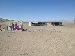
Luning is located in Mineral County 25 mile east of Hawthorne at the junction of US 95/NV 361. Luning was created as a rail siding community of the Carson and Colorado Railroad in 1881. Reportedly there was about 90 people left on the 2005 census of Luning but the population seems to have sunk far lower than that by 2014. Apparently Luning was used as a transfer station for Magnesium mines in Gabbs starting in the Mid-1950s. There isn't much left in Luning today aside from rows of abandoned buildings.


Luning sits on the west bank of a large dry lake. There are several large salt flats along the US 95 corridor in Nevada.

I did find an 1883 map of Nevada showing Luning already as an established locale.
1883 Map of Nevada
Mina is located approximately 9 miles south of Luning on US 95. Mina apparently was built next to the site of Soda Springs which was a rail siding town along the Carson and Colorado Railroad (which also can be seen on the above map). The Southern Pacific Railroad bought out the Carson and Colorado Railroad by 1900, the northern extent of the line was converted from narrow gauge to standard rails. Mina was created in 1905 the Southern Pacific was completing the conversion to a standard gauge line. Mina in turn replaced Soda Springs which apparently died out by 1917. The Tonopah and Goldfield Railroad ran from Goldfield northeast to Mina from 1905 to 1947. There is more evidence in Mina of modern road side services than in Luning but pretty everything is boarded up shut.


30 miles south of Mina is the ruins of Coaldale in Esmeralda County at the junction of US 6 and US 95. Coaldale was located was established in 1911 as a coal mining community on the Tonopah and Goldfield Railroad. The coal mining claims in the Silver Peak Range south Coaldale were apparently known all the way back to the Mid-1890s. There isn't much left in Coaldale today aside from the burnt out ruins of a service station/motel which was operation from the 1940s until the 1990s when it burned down.


The crown jewel of all the town sites I checked out is Goldfield which is still the county seat of Esmeralda County 27 miles south of Tonopah on US 95. Goldfield was founded back in 1902 after mining claims were struck. Goldfield was a hugely successful boom town which apparently reached a population of 20,000 by 1906 which would have made it the largest city at the time in Nevada. Goldfield became the county seat of Esmeralda County in 1907 which it took from the previous seat of Hawthorne (the original seat was Aurora which was once thought to be in California which is one of the weirdest surveying stories I've ever heard). By 1910 the mines of Goldfield were already in decline and the city had dropped to an approximate population of about 5,000. By 1919 all the large mining companies had moved out and by 1923 a large portion of Goldfield was destroyed in a fire.
To qualify how weird Goldfield is you have to look at the population of Esmeralda County which is about 800. Goldfield contributes less than 300 people to the total population of Esmeralda County and is the county seat despite no longer being incorporated. The streets of Goldfield are lined with high rise buildings and crumbling ruins that attest to a city that was once the largest in the state. Goldfield can be seen as a setting in the original Vanishing Point and even the post-apocalyptic backdrop of Cherry 2000.
Some of the more notable buildings still standing in Goldfield are the Goldfield Hotel and Goldfield High School. The Goldfield Hotel is located at the corner of US 95 and Columbia Avenue. The Goldfield Hotel was completed in 1908 and has 150 rooms that now sit unoccupied.


Columbia Avenue has various other derelict buildings that are still standing mostly intact.


The remains of Goldfield High School are located at the corner of Ramsey Street and Euclid Avenue.

Comments