Back in March the Sierras were clearing up finally after a rough winter and I decided to hit a road I wanted to always try; Yokohl Valley Drive.

Yokohl Valley Road/Mountain Route 296 is a 23 mile road in the Sierra Nevada Range in Tulare County. Yokohl Valley Road has a north terminus at CA 198 and gradually winds through the foothills and lower mountains in a southeasterly direction to reach County Route J37. Yokohl Valley Road is extremely narrow but manages to maintain a center stripe for the duration of the route. There is a couple large hairpins in addition to a large grade that ascends to approximately 2,700 feet above sea level a couple miles north of the J37 junction. I'm unsure on how old Yokohl Valley Road is but it does appear as a county maintained roadway in 1935 on a Tulare County Highway Map.
I started out on Yokohl Valley Drive from CA 198 in the village of Yokohl and headed southward towards J37. Most rural mountain roads in Tulare County have a Mountain Route number and Yokohl Valley Drive is not exception being assigned with MTN 296.
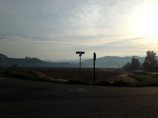
The asphalt quality on Yokohl Valley Drive quickly drops off south of CA 198.

About the only semi-significant junction on Yokohl Valley Drive is Road 228 which traverses towards Lindsay. Yokohl Valley Drive begins to follow Yokohl Creek from Road 228 east towards the Sierras.

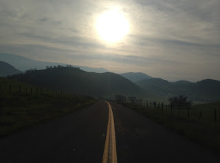
The views of the Sierras is fantastic after a winter storm.

Pretty soon Yokohl Valley Drive begins to ascend into the Sierras. The roadway is somewhat straight but it doesn't last too long.


There is a stern warning to trucks buses to not continue as Yokohl Valley Road rises above 1,000 feet.

The grade Yokohl Valley road travels is pretty big and tops out at a summit of about 3,000 feet above sea level. There is one hard hairpin curve and several other smaller ones. The view looking back at the road you just climbed near the top puts the height of the climb in stark relief.


Yokohl Valley Drive descends down to J37 on much softer grades. The roadway is pretty rough but something I didn't consider to be too difficult.


At the end of Yokohl Valley Drive the road meets J37. I actually found a surprise I wasn't expecting, Signed County Route J37 was actually signed!


I've never found any of the Signed County Routes in Tulare County aside from J37 to actually be signed, I was actually shocked to see shields. J37 begins at Springdale and traverses 25.17 miles northeast to Mount Home State Forest which is a large grove of Sequoia Redwoods. Balch Park Road appears to be very old in design and appears on County Highway Maps in 1937. There is at least one bridge from 1927 over Sycamore Creek which may suggest that was when the route was built. The J37 designation was assigned in 1975 and was one of the later Signed County Routes to be designated.


Yokohl Valley Road/Mountain Route 296 is a 23 mile road in the Sierra Nevada Range in Tulare County. Yokohl Valley Road has a north terminus at CA 198 and gradually winds through the foothills and lower mountains in a southeasterly direction to reach County Route J37. Yokohl Valley Road is extremely narrow but manages to maintain a center stripe for the duration of the route. There is a couple large hairpins in addition to a large grade that ascends to approximately 2,700 feet above sea level a couple miles north of the J37 junction. I'm unsure on how old Yokohl Valley Road is but it does appear as a county maintained roadway in 1935 on a Tulare County Highway Map.
I started out on Yokohl Valley Drive from CA 198 in the village of Yokohl and headed southward towards J37. Most rural mountain roads in Tulare County have a Mountain Route number and Yokohl Valley Drive is not exception being assigned with MTN 296.

The asphalt quality on Yokohl Valley Drive quickly drops off south of CA 198.

About the only semi-significant junction on Yokohl Valley Drive is Road 228 which traverses towards Lindsay. Yokohl Valley Drive begins to follow Yokohl Creek from Road 228 east towards the Sierras.

The views of the Sierras is fantastic after a winter storm.

Pretty soon Yokohl Valley Drive begins to ascend into the Sierras. The roadway is somewhat straight but it doesn't last too long.


There is a stern warning to trucks buses to not continue as Yokohl Valley Road rises above 1,000 feet.

The grade Yokohl Valley road travels is pretty big and tops out at a summit of about 3,000 feet above sea level. There is one hard hairpin curve and several other smaller ones. The view looking back at the road you just climbed near the top puts the height of the climb in stark relief.


Yokohl Valley Drive descends down to J37 on much softer grades. The roadway is pretty rough but something I didn't consider to be too difficult.


At the end of Yokohl Valley Drive the road meets J37. I actually found a surprise I wasn't expecting, Signed County Route J37 was actually signed!


I've never found any of the Signed County Routes in Tulare County aside from J37 to actually be signed, I was actually shocked to see shields. J37 begins at Springdale and traverses 25.17 miles northeast to Mount Home State Forest which is a large grove of Sequoia Redwoods. Balch Park Road appears to be very old in design and appears on County Highway Maps in 1937. There is at least one bridge from 1927 over Sycamore Creek which may suggest that was when the route was built. The J37 designation was assigned in 1975 and was one of the later Signed County Routes to be designated.


Comments