Continuing on our series on traveling in Iceland, we'll explore the
Golden Circle, which is a popular tourist route in Iceland. The
Golden Circle is easily accessible from Reykjavik and includes such must-see places like
Thingvellir National Park (spelled as Þingvellir in the Icelandic language),
Geysir, which yes, is a geyser, and the
Gullfoss waterfall.So yes, the Golden Circle includes a little bit of everything that Iceland has to offer. For those of you playing at home, I drove the
Golden Circle in a clockwise fashion with an impromptu diversion towards the end of my loop, which meant that I missed the hydroponic tomato farm, but I discovered a few other neat things, so it all worked out in the end.
 |
| The Golden Circle is actually a hodgepodge of different routes and becomes scenic in a hurry. It would be best to have a map or GPS with you, since there aren't really any special signs that say Golden Circle. At least from what I noticed. | |
|
 |
| I wasn't joking. We haven't even gotten to the good stuff yet. |
 |
| Getting closer to Thingvellir, or is it Þingvellir? |
 |
| Let's go check out Þingvellir. |
Thingvellir (Þingvellir) is actually situated within the rift valley that separates the Eurasian and North American tectonic plates, as the site where the Alþingi or Althing (in English), which is the Icelandic Parliament met between the years 930 and 1798. So as you can tell, there is a lot of history in Thingvellir, both of the
geological and
political varieties.
 |
| Lots of places to take a walk around in Thingvellir, as this Icelandic wayfinding sign indicates. |
 |
| You can actually hike within the rift valley here. I did that for a while actually. |
 |
| Or you can see a waterfall. This is Öxarárfoss, or Oxararfoss to the English speaker. It is supposedly a man-made waterfall from the Middle Ages (so Parliament could have good water), but it's neat nonetheless. |
 |
| Then it becomes this nice little stream. |
 |
| The scenery at Thingvellir can be quite intoxicating. That is Iceland's largest lake, Lake Thingvallavatn (Þingvallavatn) in the distance. |
 |
| Rift valley action. |
 |
| From what I can best tell, this is a distance marker of some sort. I'm not sure if it is meant to be for touring purposes, or if it is a replica of an older marker. This is pointing out that it is 49km to the small village of Skalholt, which we'll come across later in our travels. | | | | |
|
Now that we have stretched our legs a bit, let's hop back on the road.
 |
| This is on Iceland Route 365, descending into the town of Laugarvatn. |
 |
| Leaving Laugarvatn on Iceland Route 37. Laugarvatn has a petrol station and a couple of places to pick up food, so a few minutes earlier, that is where my friends and I stopped for lunch... |
 |
| ...and took this infamous picture of me during our lunch stop. Yes, in Iceland, and in Europe in general, Cool Ranch flavored Doritos are known as the Cool American flavoured Doritos. After all, wouldn't you say that the gent in the picture is a cool American? I think that the factory that makes and packages these Doritos is located somewhere in the United Kingdom. I also got to try paprika flavored Bugles during this trip. |
 |
| Galivanting around the Icelandic countryside. |
 |
| We're at Geysir! Time to stretch our legs again. |
 |
| Strokkur, which is one of the most reliable geysers in Iceland. Think of it as the Old Faithful of Iceland. |
 |
| Strokkur, again. Just wanted to give you an idea of how tall the water erupts from the geyser. |
 |
| You have a bunch of smaller geysers that don't erupt as faithfully around Geysir. |
 |
| Back on Iceland Route 35 now (we joined it before we got to Geysir), we're now heading to the Gullfoss waterfall. We also have mention of one of the F-Roads of Iceland, which are seasonal roads around the highlands of Iceland. In order to drive on the F-Roads, you'll need to have a 4x4 vehicle. One of the vehicle rental companies of Iceland, Sadcars, has a guide on how to drive on the F-Roads. |
 |
| On Iceland Route 35. I just like this picture. |
 |
| Not sure if this is supposed to be an Iceland Route 35 or Iceland Route F35. The parking lot for Gullfoss is on our right. |
 |
| A gate for the beginning of Iceland Route F35. This F-Road was still open at the end of September, but the F-Roads are usually closed for the winter around this time. |
 |
| I'm pretty sure that's a glacier. |
 |
| Scenic view on the Iceland Route F35 near Gullfoss. The Icelandic Highlands are supposed to have some dramatic scenery, just like the rest of the country. Speaking of dramatic scenery... |
Gullfoss is one of Iceland's largest and most powerful waterfalls. I believe that Dettifoss, located in the north of Iceland, is the most powerful waterfall in the country. For being a huge fan of waterfalls, Gullfoss is definitely worth the visit. As I was to find out,
Gullfoss was preserved due to the efforts of a local woman who did not want investors to use the waterfall to produce electricity. So instead, we still have this waterfall for all to enjoy.
Some waterfall pictures...
Now back on the road to check out Skalholt and back to Reykjavik.
 |
| Iceland has a lot of one lane bridges. On a road that is well traveled, it can pretty clogged in a hurry. |
 |
| I like country drives such as this scene on Iceland Route 35 going in a southerly direction. |
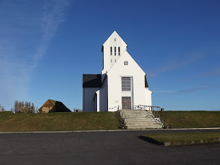
I decided to take Iceland Route 31 on a whim instead of continue on Iceland Route 31 back to the Ring Road and Selfoss. I'm glad I did, because I found
Skalholt, which is a neat place to check out and is one of the most
historic places in Iceland. There's ruins of an old Icelandic village and a church with a lot of historical artifacts, but unfortunately, the church was closing up shop for the day.
That was our last touristy stop on the Golden Circle Tour. From there, we took an alternative way back to Reykjavik, taking Iceland Routes 31 and 30 back to Iceland Route 1 (the Ring Road!) to Selfoss and then back to Reykjavik. I'm sure going back to Iceland Route 35 would have also been very nice (as it was north of Skalholt), but the alternate route was still rather neat.
 |
| The suspension bridge at Laugaras over the Ölfusá. I wasn't able to find a specific name for the bridge other than Laugaras Bridge. |
 |
| The suspension bridge at Laugaras. |
 |
| Southeast of Laugaras on Iceland Route 31. |
 |
| Icelandic horses. |
 |
Approaching the end of Iceland Route 31.
I'm not sure if I've ever gotten a smiley face for staying under the speed limit before.
|
 |
| END! Iceland Route 30, at Iceland Route 1. If I make a left, I'll head straight into a slang term. I'll have a Hella good time another day, but now to head back to Reykjavik via Selfoss. |
 |
| Danish sign style, British Transport font. |
 |
| Agricultural scenery on Iceland Route 1 approaching Selfoss. |
 |
| In the United States, this would probably be a traffic light. But in Iceland, they prefer roundabouts. |
 |
| Climbing the ridge between the Eurasian and North American tectonic plates and back towards Reykjavik from there. |
 |
| Still climbing said ridge. |
 |
| I'm not sure what the blank highway shield is for, maybe a route expansion of some sort. It's at a trumpet intersection between Iceland Route 1 and Iceland Route 39. I took the road that is signed from this exit later during the trip and it is a very surreal drive. |
 |
| Not much sooner until we get back into Reykjavik and that is where we end for today. |
I hope that you enjoyed the second installment of the roads of Iceland. For the third part of the series, we go a little bit north of Reykjavik, around a fjord, to a seaside town and through a tunnel.
Icelandic Highways and Byways Series
Icelandic Highways and Byways (Part 1) -
Reykjavik
Icelandic Highways and Byways (Part 2) - Golden Circle


 Some waterfall pictures...


 Now back on the road to check out Skalholt and back to Reykjavik.


 That was our last touristy stop on the Golden Circle Tour. From there, we took an alternative way back to Reykjavik, taking Iceland Routes 31 and 30 back to Iceland Route 1 (the Ring Road!) to Selfoss and then back to Reykjavik. I'm sure going back to Iceland Route 35 would have also been very nice (as it was north of Skalholt), but the alternate route was still rather neat.


Comments