
The combined corridor of Hawaii Route 200 and Hawaii County Route 200 is 52.7 miles in length across the center of the Big Island. The County portion is approximately 8 miles comprising Waianuenue Avenue and Kaumana Drive in the Hilo area. The remaining 44.7 miles is comprised of the State-owned highway over the modern Saddle Road (Daniel K. Inouye Highway) to Hawaii Route 190. The Saddle Road crosses Humuula Saddle via a plateau located at 6,632 feet above sea level between Mauna Kea, Mauna Loa and Hualalai.
The origin of the Saddle Road came in 1873 when a road was constructed to the Humuula Sheep Station from Waimea. This roadway was connected to a foot trail east to Hilo. This early corridor was developed into the Saddle Road by the U.S. Army in 1943 to aid their efforts during World War II. The early Saddle Road would become Hawaii Route 20 in 1955 and would be later renumbered to Hawaii Route 200. The modern Saddle Road began to be constructed between 2007-2013 and is planned to be extended west to Hawaii Route 19.

This page is part of the Gribblenation Hawaii Roads series. A compellation of all Hawaii-related media from both Gribblenation and RoadwayWiz can be found by clicking here.

Part 1; the history of Hawaii Route 200 and the Saddle Road
The interior of the Big Island of Hawaii historically has been a hostile and unforgiving volcanic terrain which has not lent itself to overland crossing. Humuula Saddle in particular lies between the active volcanos of Mauna Kea, Mauna Loa and Hualalai. There is little evidence to suggest Humuula Saddle was widely used during the era of ancient Hawaii.
During May 1849 the Kingdom of Hawaii's Minister of Finance Gerritt P. Judd proposed roadway across the Big Island. The so-called "Judd Trail" originated at Holualoa Bay near Kailua-Kona and headed directly east towards a plateau south of Hualalai. The highway made to 19°38'38.0"N 155°45'12.0"W before it was destroyed in 1859 by an eruption from Mauna Loa (Wikipedia citation #10 The Hawaiian Kingdom, Volume 2 1854-1874). The remaining Judd Trail is still visible as a straight-line roadway on modern map imagery.

The Judd Traill appears on maps well into the Twentieth Century. The trail can be seen prominently on the 1930 Hilo Chamber of Commerce map of the Big Island.

By 1873 a dirt roadway had been constructed from Waimea to Humuula Sheep Station in Parker Ranch. This early road was connected to a foot trail east to Hilo. The Humuula Sheep Station-Hilo Trail can be seen on the 1930 Hilo Chamber of Commerce map of the Big Island.

By 1936 Kaumana Road had been constructed to the western extent of Hilo which connected to the trail to Humuula Sheep Station. The Saddle Road was constructed from Humuula Sheep Station east to Hilo by the U.S. Army Corps of Engineers during 1943 amid World War II (Wikipedia citation #13). The Saddle Road was initially just a gravel grade which intended to facilitate accelerated troop movements over the Big Island.
Hawaii Route 20 can be seen spanning from Mamalahoa Highway near Waimea east to Hilo on the 1959 Gousha Hawaii map of Hawaii. Hawaii Route 20 and the Saddle Road served as a cutoff for the northern half of Hawaii Route 19/Mamalahoa Highway.

During the late 1970s the Saddle Road corridor was renumbered to Hawaii Route 200 which denoted it being a secondary state highway. The early Saddle Road was infamous for carrying high grades and not being well suited to facilitate modern freight traffic. Much of the corridor improvements to the Saddle Road would be born out of an acceptance of an Environmental Impact Stady in 1999.
Much of the original alignment of Hawaii Route 200 in Hilo was bypassed in September 2004 with the opening of Hawaii Route 2000 along Puainako Street to Kaumana Drive near Country Club Road. The opening of the initial segment of Hawaii Route 2000 saw the designation of Hawaii County Route 200 along Kaumana Drive and Waianuenue Avenue to Hawaii Route 19 in downtown Hilo.
Hawaii Route 200 was rerouted north of Bradshaw Army Airfield in two phases from May 2007 to August 2009 between Mile Markers 28-42. The older Saddle Road was rebranded as the "Lightning Trail" and was maintained as Hawaii Route 201 until around 2013. East of the Army Airfield the corridor was expanded between Mile Markers 11-28 during 2008-2011.
During September 2013 a new segment of Hawaii Route 200 opened west of Mile Marker 41.5 west to Hawaii Route 190. This new segment bypassed the original alignment of the Saddle Road towards Waimea. The entire corridor of Hawaii Route 200 was renamed as "Daniel K. Inouye Highway" in honor of the Hawaiian Senator.
Hawaii Route 2000 was extended west of Country Club Drive to western Kaumana Drive between Mile Markers 6.5-8.5 in recent years. This truncated the Hawaii Route 200 as beginning at western Kaumana Drive while also simultaneously extending Hawaii County Route 200.
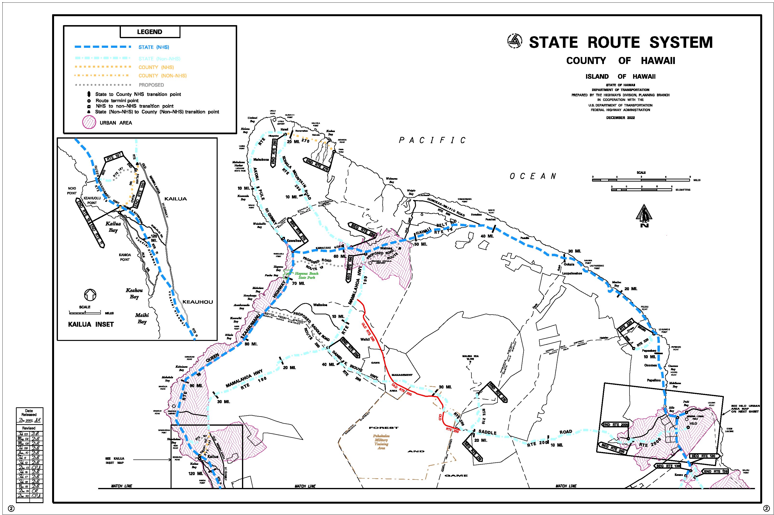
The corridor of Hawaii Route 200 and Daniel K. Inouye Highway was originally planned to be extended west of Hawaii Route 190 to Hawaii Route 19 by 2019. The corridor has stalled in the Environmental Study phase, and it isn't clear when it will be constructed. The planned extension can be seen on the 2022 Hawaii Department of Transportation maps. The map also displays the original Saddle Road as "Old Hawaii Route 200."


Part 2; a drive on Hawaii County Route 200
Westbound Hawaii County Route 200 begins as Hawaii Route 19 intersects Waianuenue Avenue south of the Wailuku River in downtown Hilo. The area now comprising Hilo was settled by the Polynesians around 1100 A.D. According to oral history the name Hilo means "to twist." The name more or less used to refer to the entire eastern coast of the Hawaiian Big Island. The modern community began to develop in the 1880s during the Sugar Cane Plantation Boom. Modern Hilo is the fourth largest settlement in state of Hawaii and largest not on Oahu with an approximate population of 44,186 (as of the 2020 census).


Hawaii County Route 200 follows Waianuenue Avenue west out of downtown Hilo. The highway transitions onto Kaumana Drive towards the Saddle Road. Waianuenue Avenue can be used to access Rainbow Falls in Wailuku River State Park.


Hawaii County Route 200 follows Kaumana Drive and intersects the former terminus of Hawaii Route 2000 at Puainako Street.


Hawaii County Route 200 continues west on Kaumana Drive and terminates at Hawaii Routes 200/Hawaii Route 2000 at the modern Saddle Road.


Westbound Hawaii Route 200 begins at Kaumana Drive. The highway quickly ascends to the center of the Big Island and has the highest posted speed limit on the island at 60 MPH. The westbound highway has climbing lanes which aid in facilitating faster passenger traffic. An overlook of Mauna Kea (elevation 13,803 feet above sea level) can be found along the climb to Humuula Saddle.


The westbound climbing lane along Hawaii Route 200 ends as the highway passes by Mauna Loa Observatory Road and Mauna Kea Access Road (Hawaii Route 210).


Hawaii Route 200 crosses over the 6,632-foot high Humuula Saddle and passes the entrance to Bradshaw Army Airfield.


Westbound Hawaii Route 200 intersects the old Waimea branch of the Saddle Road at approximately Mile Marker 41.5.


Hawaii Route 200 begins a westward descent via 7% grades and terminates at Hawaii Route 190.


Comments