
Hawaii Route 19 is part of the Hawaii Belt Road and the second longest State Highway in Hawaii at approximately 107 miles. The corridor begins at Hawaii Route 11 in Kailua-Kona and loops the northern end of the Big Island to the Port of Hilo. Hawaii Route 19 is one of the original 1955 era State Highways designated on the Big Island and historically is tied mostly to the Mamalahoa Highway. Mamalahoa Highway originates from the 1783 Law of the Splintered Paddle which was declared by Kamehameha I.
Much of Hawaii Route 19 along the northern coast of the Big Island is built over the grade of the Hawaii Consolidated Railroad during the 1960s. Upon the completion of Queen Kaahumanu Highway in 1975 Hawaii Route 19 was realigned onto the then new corridor between Kailua-Kona and Kawaihae Road. The same alignment shift consumed much of Hawaii Route 26 and a portion of Hawaii Route 25 to Waimea. The originally Kailua-Kona-to-Waimea of Hawaii Route 19 was subsequently renumbered to Hawaii Route 190.

This page is part of the Gribblenation Hawaii Roads series. A compellation of all Hawaii-related media from both Gribblenation and RoadwayWiz can be found by clicking here.

Part 1; the history of Hawaii Route 19
Hawaii Route 19 is part of the Hawaii Belt Road and is the second longest Hawaiian State Route at approximately 107 miles. The highway begins at the mutual junction of Hawaii Route 11 and Hawaii Route 190 in Kailua-Kona. From Kailua-Kona the routing of Hawaii Route 19 crosses the volcanic landscapes of western side of the Big Island via Queen Kaahumanu Highway. From the end of Queen Kaahumanu Highway, the alignment of Hawaii Route 19 shifts east via Kawaihae Road to Waimea. The corridor from Waimea follows the northern shore of the Big Island via the improved Mamalahoa Highway to Hilo where it finds a terminus at the Port of Hilo.
Mamalahoa Highway was declared by royal decree in 1783 via the Law of the Splintered Paddle. The law was conceived based off an incident Kamehameha I was part of along the Puna coast. During said incident Kamehameha I and his men were conducting a shoreline raid when they encountered two Puna fisherman. While pursuing the fisherman across a lava field one of Kamehameha's feet was caught in a rock. The fishermen seized upon the opportunity to retaliate and struck Kamehameha in the head with a wooden paddle.
Kamehameha opted to not retaliate against the fisherman and used the incident as the basis of the Law of the Splintered Paddle. The law essentially guaranteed safe passage to all travelers across the Hawaiian Islands and was used as a basis of Mamalahoa Highway on the Big Island. The highway corridor was rapidly developed across the Big Island and was mostly annexed as early automotive roads.
Much of Mamalahoa Highway on the Hamakua Coast of the Big Island acted as frontage of the Hawaii Consolidated Railway Hamakua Division. The railroad took the best grade alignments possible north from Hilo to Paaulio. The first phase of the Hamakua Division opened between Hilo and Hakalau by 1911. The line was extended north to Paaulio by 1913. The Hamakua Division was an impressive effort which required installation of 35 bridges and 3 tunnels.
The winding early Mamalahoa Highway can be seen contrasted to the streamlined Hamakua Division on the 1930 Hilo Chamber of Commerce map of the Big Island.

The same map displays the Hamakua Division alignment in Hilo. The line is shown following the shore of Hilo Bay towards Hoolulu Park. Mamalahoa Highway is shown following Wainaku Street over the Wailuku River into downtown Hilo. The Hawaii Consolidated Railway continued south flanking Hilo Airport via branches to Glenwood and Puna.

Much of the Hamakua Division was destroyed by a tsunami on April 1, 1946. The division was abandoned by the Hawaii Consolidated Railway during December 1946. Sugar plantation owners attempted to repurpose intact portions of the line north of the Wailuku River, but all were also abandoned by late 1948.
One of the first portions of the Hamakua Division to be repurposed as part of a realigned Mamalahoa Highway came in 1950. During said year the right-of-way in Hilo was used as the basis for Bayfront Highway. The Wailuku River Bridge piers were reused for construction of a new highway bridge which removed significant amounts of traffic north/south from downtown Hilo.
In 1955 the Hawaii Route System was modified and expanded to the Big Island. The northern half of Mamalahoa Highway from Kailua-Kona to Hilo was assigned Hawaii Route 19. The early routing of Hawaii Route 19 can be seen on the 1959 Gousha Map of Hawaii. As originally configured Hawaii Route 19 began at Hawaii Route 11 at the intersection of Kaukina Highway/Palani Road in Kailua-Kona and ended at Hawaii Route 12 at the intersection of Kamehameha Avenue/Kanoelehua Avenue in Hilo.

The final segment of the Old Mamalahoa Highway on the northern side of the Big Island and Hamakua Coast was replaced with a modern highway in September 1963. The last corridor which was realigned was from Mud Lane near Waimea east to Honokaa (information courtesy Oscar Voss's hawaiihighways.com). By the time the entirety of Hawaii Route 19 from Paaulio to Hilo had been realigned onto the grade of the Hamakua Division. Presently the highway uses five intact Hamakua Division bridges while three other spans are salvaged from parts of the line.
During 1975 Queen Kaahumanu Highway was completed from Kailua-Kona to Hawaii Route 26 (Kawaihae Road). The corridor was originally intended to serve as an extension of Hawaii Route 11 but instead was used as realignment of Hawaii Route 19 between Kailua-Kona and Waimea. The then new Kailua-Kona to Waimea routing of Hawaii Route 19 consumed much of Hawaii Route 26 and several miles of Hawaii Route 25. The original alignment following Mamalahoa Highway from Kailua-Kona to Waimea was renumbered as Hawaii Route 190. A portion of Hawaii Route 12 (later Hawaii Route 120) was also used to extend Hawaii Route 19 to the Port of Hilo.
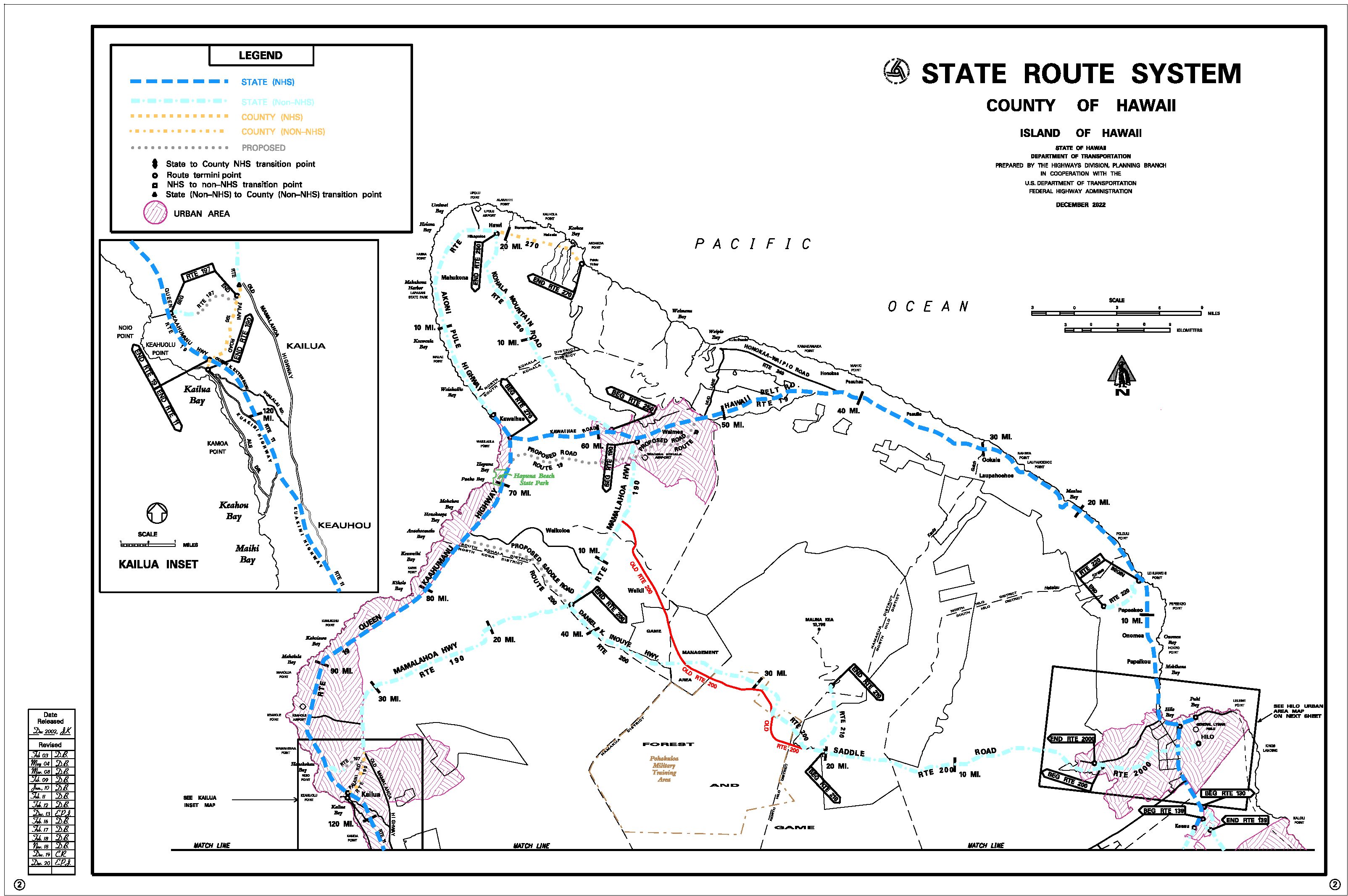
A proposed bypass of Waimea and Kawaihae Road appears on the 2022 Hawaii Department of Transportation map of the Big Island. It is unclear when this corridor will be constructed as the new alignment of Hawaii Route 19.

Part 2; a drive on Hawaii Route 19 from Kona International Airport to Hawaii Route 11 in Kailua-Kona
From Keahole Airport Road the alignment of Hawaii Route 19 southbound follows Queen Kaahumanu Highway. The highway intersects the hidden Hawaii Route 197 at Kealakehe Parkway.


Hawaii Route 19 follows Queen Kaahumanu Highway into Kailua-Kona where it terminates the mutual junction of Hawaii Route 11, Hawaii Route 190 and Hawaii County Route 187.


Part 3; a drive on Hawaii Route 19 from Kona International Airport to Hilo
Hawaii Route 19 north from Kona International Airport follows Queen Kaahumanu Highway approximately 27 miles along the western coast of the Big Island to a junction with Hawaii Route 270 near Kawaihae. Along the way the highway passes by Kekaha Kai State Park, West Hawaii Veterans Cemetery and Hapuna Beach State Park.


Hawaii Route 19 turns east on Kawaihae Road and climbs into the southern foot of Kohala Mountain. The highway enters Waimea where it intersects both Hawaii Route 250 (Kohala Mountain Road) and Hawaii Route 190 (Mamalahoa Highway). Hawaii Route 19 makes a left-hand turn onto Mamalahoa Highway.


Waimea is the home of Parker Ranch and has a long history in the sport of steer roping.


Hilo is approximately 55 miles away from Waimea on the Mamalahoa Highway segment of Hawaii Route 19. The highway passes through Ahuloa and intersects Hawaii County Route 240 at Honokaa. Hawaii County Route 240 can be used to access Waipio Valley Road and the Waipio Valley Lookout. Hilo is signed as being 39 miles from Honokaa.


Hawaii Route 19 enters the Hamakua Coast region. The highway passes numerous gorges in addition to passing through the communities of Paauhau, Paauilo, Laupahoehoe, Weloka and Ninole. The highway crosses over the longest remaining Hamakua Division rail bridge at Hakalau Stream (Mile Marker 15.30). The Hakalau Stream Bridge is 722 feet long.


Hawaii Route 19 crosses another Hamakua Division bridge at Paheehee Stream (Mile Marker 13.31). Upon crossing the bridge Hawaii Route 19 intersects Hawaii Route 220. Hawaii Route 220 can be used to access Akaka Falls State Park and Honomu. Hawaii Route 19 from Honomu is signed as 11 miles from Hilo.


Hawaii Route 19 swings southward towards Hilo. The highway passes through Pepeekeo, Papaikou and Paukaa. The highway intersects Wainaku Road which was the former alignment of Hawaii Route 21 at the northern outskirts of Hilo.


Hawaii Route 19 crosses the Wailuku River Bridge and intersects Hawaii County Route 200 at Waianuenue Avenue in downtown Hilo.


Hawaii Route 19 follows Bayfront Highway and merges into Kamehameha Avenue.


Hawaii Route 19 crosses the Wailoa River Bridge via Kamehameha Avenue and intersects Hawaii Route 11 at Kanoelehua Avenue. Hawaii Route 19 continues east onto Kalanianaole Street.


Hawaii Route 19 follows Kalanianaole Street to Kuhio Street where it terminates at the Port of Hilo. Kalanianaole Street Kamehameha Avenue continues 0.2 miles east of Kuhio Street as the unsigned Hawaii Route 1370 to Pua Avenue. Beyond Pua Street the remaining balance of Kalanianaole Street is county maintained.


Comments