
Hawaii Route 310


Hawaii Route 310 is a 3.6-mile State Highway located on the Island of Maui.  Hawaii Route 310 begins at the junction of Hawaii Route 31/Hawaii Route 311 in Kihei and heads westward along Maalaea Bay toward a terminus at Hawaii Route 30.  Hawaii Route 310 follows North Kihei Road through it's entire routing and was once part of Hawaii Route 31.  The cover photo of this blog is an eastward view of Hawaii Route 310 facing towards Maalaea Bay, Kihei and Haleakala.  


This page is part of the Gribblenation Hawaii Roads series.  A compellation of all Hawaii-related media from both Gribblenation and RoadwayWiz can be found by clicking here


Part 1; the history of Hawaii Route 310

The Island of Maui seemingly was not part of the original World War II era Hawaii Route System.  Circa 1955 the United States Bureau of Public Roads renumbered the Hawaii Route System.  The 1955 Hawaii Route Renumbering saw most of the conventions utilized by the current Hawaii State Route System established.  Primary Hawaii Routes were given two-digit numbers whereas Secondary Hawaii Routes were given three-digit numbers.  The Hawaii Routes were assigned in sequence for what Island/County they were located on coupled with what Federal Aid Program number they were tied to.  In the case of the Island of Maui it was assigned numbers in the range of 30-40.  

Hawaii Route 31 as originally defined began at Hawaii Route 30 and followed what is now North Kihei Road and South Kihei Road into Kihei.  From Kihei the routing of Hawaii Route 31 is unclear and may have had a gap between Makena east towards Hawaii Route 37/Kula Highway.  From Hawaii Route 37/Kula Highway the routing of Hawaii Route 31 continued east via Piilani Highway towards Hawaii Route 36 in Hana.  Hawaii Route 31 as originally configured can be seen on the 1959 Gousha Map of Hawaii.  Hawaii Route 31 is noted to be a secondary highway.


During the 1960s the Hawaii Route system was simplified, and numerous segments of important roadways were adopted from the counties.  According hawaiihighways.com North Kihei Road was adopted as State Highway whereas South Kihei Road remained maintained by Maui County.  According to hawaiihighways.com North Kihei Road was reassigned as Hawaii Route 310 but remained field signed as Hawaii Route 31.  

During 1981 the first segment of the State Maintained Hawaii Route 31 on western Piilani Highway in Kihei opened.  During April 1981 Hawaii Route 310 was extended 0.1 miles to reach the new alignment of Hawaii Route 31 in Kihei at western Piilani Highway.  


Part 2; a drive on Hawaii Route 310

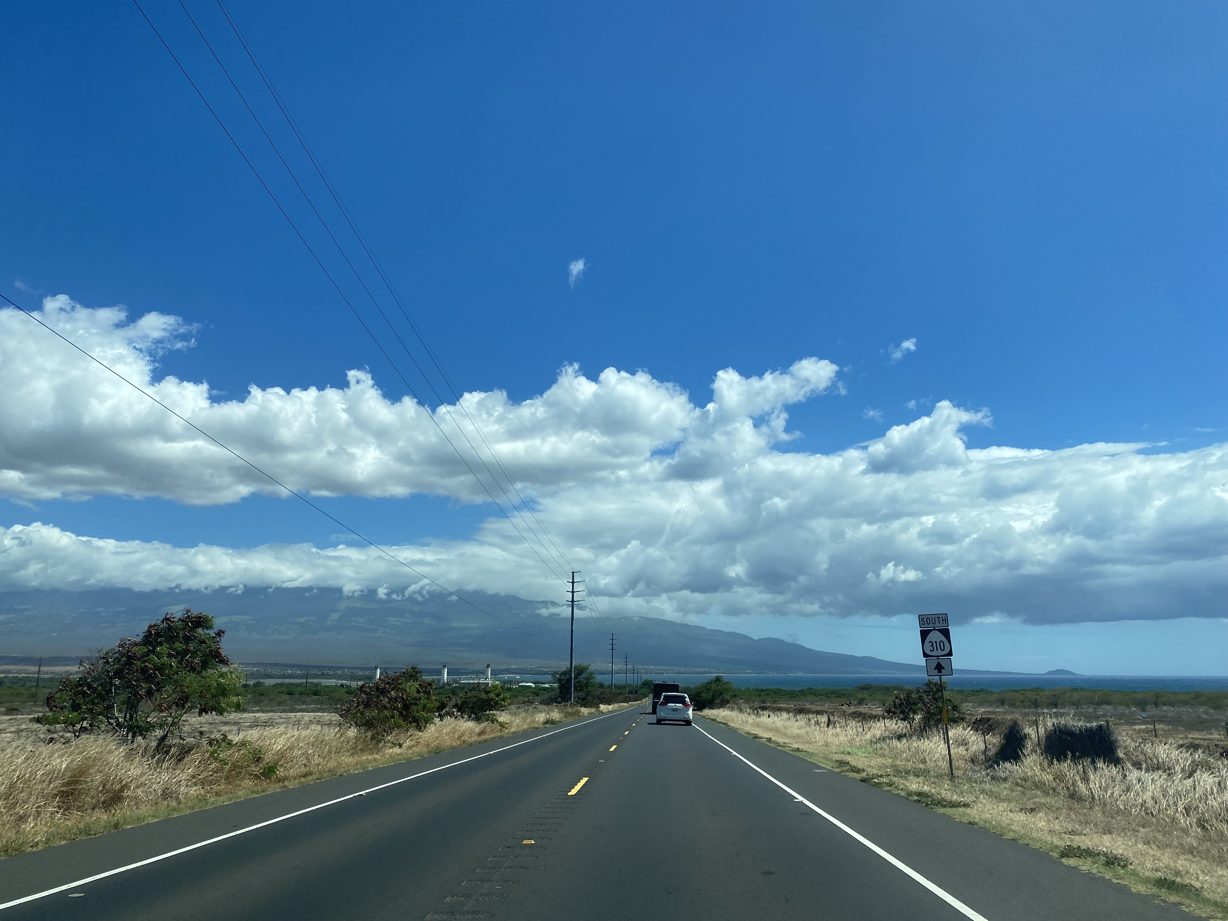
Eastbound Hawaii Route 310 originates from Hawaii Route 30/Honoapiilani Highway near Maalaea.  


Hawaii Route 310 eastbound descends towards the waters of Maalaea Bay.  Traffic on Hawaii Route 310 can access Kealia Pond the and Kealia Coastal Boardwalk.  


From Kealia Pond, Hawaii Route 310 continues eastward and intersects former Hawaii Route 31 South Kihei Road.  


Hawaii Route 310 eastbound terminates at the intersection of Hawaii Route 31 and Hawaii Route 311 at the outskirts of Kihei.  


Comments

Popular posts from this blog

Did Caltrans just kill the G26 cutout US Route shields?

The US Route System was formally created by the American Association of State Highway Officials during November 1926.  Through the history of the system the only state to which has elected to maintain cutout US Route shields has been California.  The G26 series cutout US Route shields have become a favorite in the road enthusiast hobby and are generally considered to be much more visually pleasing than the standard Federal Highway Administration variant.  However, the G26 shield series appears to have been killed off on January 18, 2026, when Caltrans updated their Manual of Uniform Traffic Control Devices.  This blog will examine the history of the US Route shield specifications in California and what is happening with the 2026 changes.  The blog cover photo is facing towards the terminus of California State Route 136 and at a G26-2 specification US Route 395 shield.  In the background Mount Whitney can be seen in the Sierra Nevada range.   ...

May 2023 Ontario Trip (Part 3 of 3)

  Over the years, I have made plenty of trips to Ontario, crisscrossing the southern, central and eastern parts of the province. Living in Upstate New York, it's pretty easy to visit our neighbor to the north, or is that our neighbor to the west? Ottawa is one of my favorite cities to visit anywhere in the world, plus I've discovered the charm of Kingston, the waterfalls of Hamilton (which is on the same Niagara Escarpment that brings us Niagara Falls), the sheer beauty of the Bruce Peninsula, and more. But I hadn't explored much of Cottage Country. So I decided to change that, and what better time to go than over Memorial Day weekend, when the daylight is long and I have an extra day to explore. On the third and final day of my trip, I started in Huntsville and made my way through Muskoka District and Haliburton County, passing by many lakes along the way. I stopped in towns such as Dorset, Haliburton and Bancroft before making a beeline down to Belleville and then over th...

Ghost Town Tuesday; Nichols, FL

A couple years ago I spent a lot of spare time exploring phosphate mining ghost towns in the Bone Valley of Polk County, Florida.  One ghost town in particular called Nichols on Polk County Route 676 west of Mulberry caught my eye due to a relative lack of documentation on ghosttowns.com. Nichols was created in 1905 during the early phosphate mining boom in the Bone Valley region.  For the time Nichols was unusual since it had company housing in the Nichols Mine site and private residences outside the gate.  Nichols is only about two miles west of Mulberry which probably made it a somewhat reasonable commute even by the wonky standards of the early 20th Century.  Most of the Bone Valley region was relatively remote which made commuting or homesteading impractical which is why there are so many ghost towns in the area.  The company housing section of Nichols was phased out and abandoned by 1950. The Nichols town site is largely abandoned and could "possibl...