The US Route 99 Business Loop in downtown Fresno was a short-lived bannered route of mainline US Route 99 which existed from June 1957 to June 1965. The corridor originally incorporated much of the original surface routing of US Route 99 in Fresno via the Monterey Street Overhead, Broadway, Divisadero Street, H Street, Belmont Avenue and North Golden State Boulevard.
The US Route 99 Business Loop was converted to one-way couplets by the city via Broadway and Van Ness Avenue as a measure to increase available downtown street parking. Southbound traffic was carried by Broadway through downtown whereas Van Ness Avenue carried northbound traffic. The Business Loop corridor would be extended south through Magala during June 1963 via South Golden State Boulevard and Chestnut Avenue to the then recently extended US Route 99 freeway.
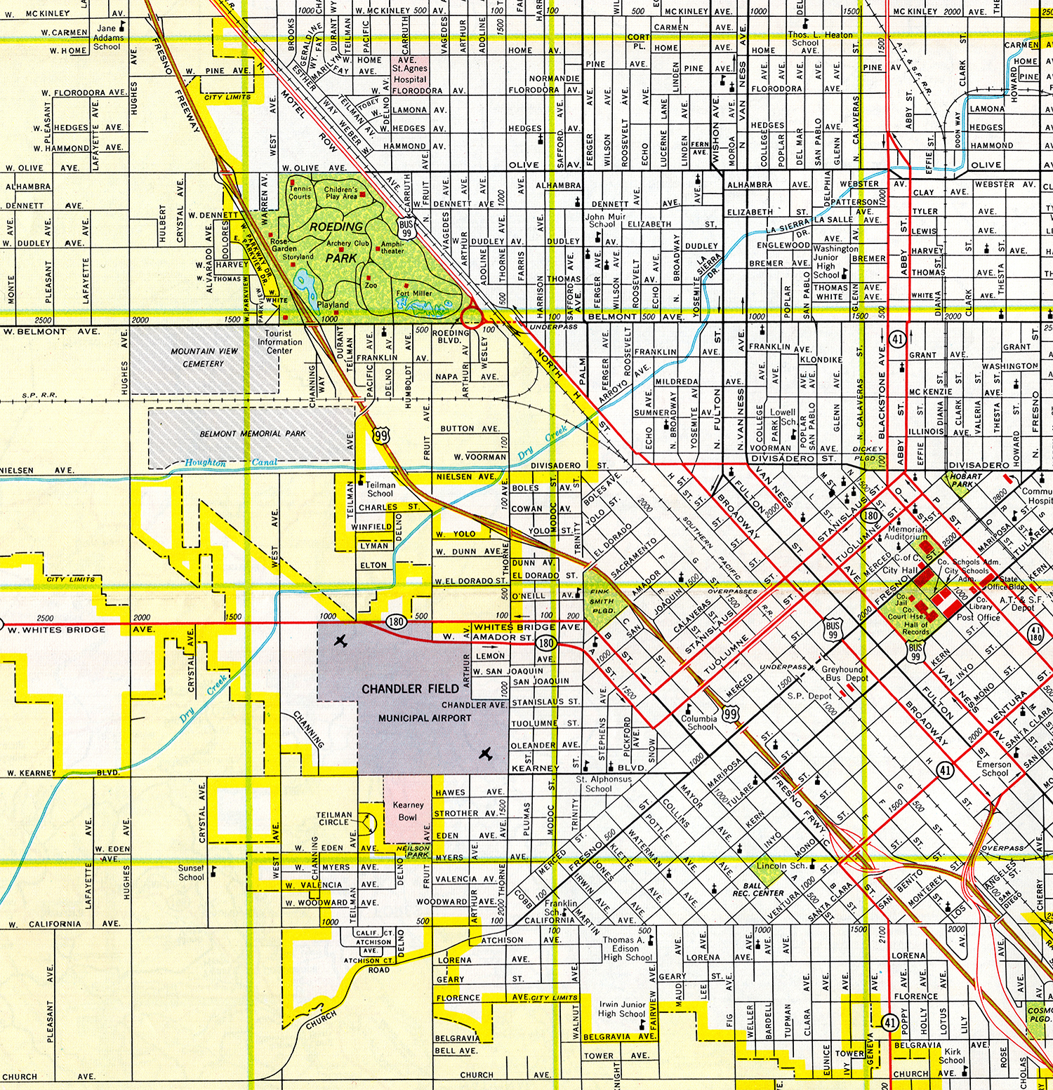
The US Route 99 Business Loop would ultimately be deleted in June 1965 when the parent highway was truncated out of California to Ashland, Oregon. The blog cover photo is the map of the Fresno Business Loop as it was submitted by Division of Highways to the American Association of State Highway Officials Executive Committee during 1957.
This blog is part of the larger Gribblenation US Route 99 Page. For more information pertaining to the other various segments of US Route 99 and its three-digit child routes check out the link the below.
The history of US Route 99 Business Loop in FresnoThis blog serves as history of the US Route 99 Business Loop in Fresno which existed from 1957-1965. A more comprehensive history of the parent highway can be found below:
In anticipation of US Route 99 (then Legislative Route Number 4) north of the Monterey Street Overhead being relocated onto a bypass freeway of downtown Fresno the Division of Highways sought to create a Business Loop through downtown Fresno. This application was approved by the American Association of State Highway Officials (AASHO) Executive Committee on June 27, 1957. The US Route 99 Business Loop originated at the Monterey Street Overhead and diverged from the start of the bypass freeway onto Broadway. The Business Loop initially followed the original alignment of US Route 99 through downtown Fresno following Broadway, Divisadero Street, H Street, Belmont Street (through the Belmont Subway and Traffic Circle) and North Golden State Boulevard back to the freeway near Clinton Avenue.


Historically US Route 99 along Broadway had always carried two-way traffic. On March 6, 1960, the
Fresno Bee reported the city was converting Broadway and nearby Van Ness Avenue as one-way couplets. Broadway was to carry southbound US Route 99 Business Loop traffic whereas Van Ness Avenue would carry northbound. The primary driver for the conversion seems the desire to create additional street parking. Fulton Street being wedged Broadway and Van Ness Avenue is cited to only have 167 available parking spaces.

The
1960 Fresno city Gousha sectional map displays the Broadway/Van Ness Avenue couplet in detail. The Northbound US Route 99 Business Loop is shown following Santa Benito Avenue from the Monterey Street Overhead to reach Van Ness Avenue. The corridor jogged up Van Ness Avenue to Divisadero Street where it consolidated with the southbound traffic at Broadway. The Business Loop intersected the couplet then carrying California State Route 180 (then Legislative Route Number 41) along Tuolumne Street and Stanislaus Street.
On June 19, 1963, AASHO approved several Division of Highways requests to create additional US Route 99 Business Loops following the relocation of the mainline highway onto a freeway through southern Fresno County. One of the corridors was an extension of the existing Business Loop in downtown Fresno. Said corridor was extended through Magala from the Monterey Street Overhead along South Golden State Boulevard and Chestnut Avenue to the then recently extended freeway.
The US Route 99 Business Loop would cease to exist by June 29, 1965, when AASHO approved a Division of Highways request to truncate mainline US Route 99 to Ashland, Oregon. It is unclear if a California State Route 99 Business Loop was maintained through downtown Fresno after US Route 99 was eliminated in the state.
In time Broadway was bisected by Fresno Executive Plaza which rendered it no longer passable for through traffic in downtown. The corridor was further broken up when construction of Chukchansi Park broke ground between Tulare Street and Inyo Street in August 2000. San Benito Street would be eventually bisected by construction of the California State Route 41 freeway. The Monterey Street Overhead would begin to degrade and was demolished in 2011. The demolition of the overhead removed the ability to move from South Golden State Boulevard directly to Broadway in downtown.
The Monterey Street Overhead can be seen in a state of abandonment prior to being demolished in a series of photos taken by Joel Windmiller in 2011. The structure had opened to traffic in 1948 as a replacement for the at-grade crossing US Route 99 once took over the Southern Pacific Railroad via Cherry Avenue.
Although no longer part of a Business Loop signage along Van Ness Avenue still directs traffic on how to reach the California State Route 99 freeway. The first photo from Van Ness Avenue approaching Tulare Street.
The second photo displays signage along Van Ness Avenue approaching Stanislaus Street.


Comments