
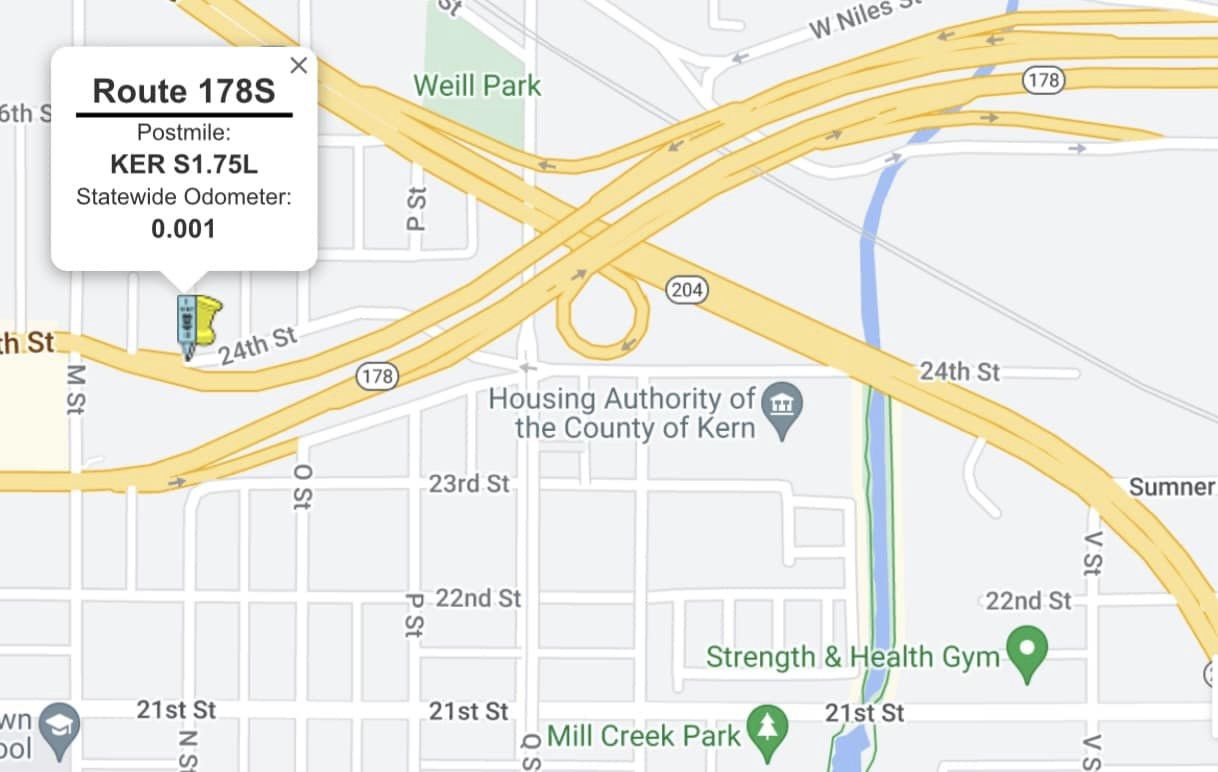
24th Street was added to the State Highway System in 1934 when Legislative Route Number 58 was realigned in downtown Bakersfield. 24th Street would be assigned as part of California State Route 178 when the Sign Route System was designated during August 1934. As part of the 1964 State Highway Renumbering California State Route 178 and California State Route 58 would begin a brief multiplex from Golden State Avenue west through downtown to US Route 99. The initial segment of the 178 freeway downtown would open east from N Street during 1966. The initial segment of the California State Route178 freeway retained the original alignment along 24th Street in addition to a frontage road from 23rd Street as a spur. The purpose of the spur is to provide continuous connectivity from mainline California State Route 178 and California State Route 204 at Golden State Avenue.

Part 1; the history of California State Route 178 Spur
The origin of what was to become California State Route 178 Spur came in 1933 with an extension of Legislative Route Number 58 (LRN 58). During said year LRN 58 was extended west from downtown Bakersfield through the coast ranges to US Route 101/LRN 2 in Santa Margarita. LRN 58 west of US Route 99/LRN 4 at Golden State Avenue was initially carried from downtown Bakersfield via 19tth Street, Pierce Road and Rosedale Highway. This early alignment of LRN 58 west of US Route 99 in Bakersfield can be observed on the 1934 Division of Highways Map.

LRN 58 west of US Route 99 was announced as part of California State Route 178 in the August 1934 California Highways & Public Works. California State Route 178 was one of the initial Sign State Routes designated in California.


LRN 58 and California State Route 178 was shifted to a new alignment along 24th Street in downtown Bakersfield at some point during 1934. The highway appears realigned onto 24th Street on the 1935 Division of Highways Map of Kern County. The 1935 maps were based off 1934 Division of Highways surveys of state-maintained roads for every county in California.

The alignment of California State Route 178 in downtown Bakersfield appears in detail on the 1938 Division of Highways Map. Heading westbound California State Route 178 followed LRN 57 on Niles Street and Baker Street to US Route 466/LRN 58 at Sumner Street. California State Route 178 multiplexed US Route 466 west to US Route 99/LRN 4 at Golden State Avenue (also the north terminus of US Route 399). California State Route 178 multiplexed US Route 99/US Route 466 briefly on Golden State Avenue and departed westward through downtown on 24th Street. From downtown Bakersfield the routing of California State Route 178/LRN 58 followed 24th Street to Rosedale Highway.

California State Route 178/LRN 58 from US Route 99/LRN 4 in Bakersfield west to Interstate 5/LRN 238 was added to the Freeway and Expressway System in 1959 via the provisions of State Highway Code 253.4. The November/December 1961 California Highways & Public Works would announce allocations for the 1962-63 Fiscal Year to obtain right-of-way for the construction of freeway alignment for California State Route 178 in Bakersfield.

The planned adopted freeway routing of California State Route 178 in Bakersfield first appears on the 1962 Division of Highways Map. The freeway is shown to begin at 24th Street in downtown Bakersfield just west of US Route 99/LRN 4. The freeway routing is shown continuing east as part of LRN 57 jogging north of Niles Street towards the Kern River Canyon.

The November/December 1963 California Highways & Public Works announced construction of the California State Route 178 freeway from M Street in downtown Bakersfield east to Mount Vernon Avenue was budgeted for the 1964-65 Fiscal Year. The project was slated to include a widening of 24th Street and conversion of 23rd Street (both legislatively as California State Route 58) to state highway standards as part of a new one-way couplet.


As part of the 1964 State Highway Renumbering the Legislative Route Numbers were dropped in favor of Sign Route designations. California State Route 178 was truncated to US Route 99 in Bakersfield. US Route 99 had been relocated to the West Bakersfield Freeway during July 1963. The newly designated California State Route 58 had absorbed the former routing of California State Route 178 west of Golden State Avenue (then renumbered to California State Route 204) to Santa Margarita. The new definitions of California State Route 178 and California State Route 58 had both highways multiplex from Golden State Avenue west on 24th Street to US Route 99. The western endpoint definition of California State Route 178 would be relaxed by 1964 Legislative Chapter 1698 as "Bakersfield." The above routings and route descriptions appear for the first time on the 1964 Division of Highways Map.


The November/December 1964 California Highways & Public Works announced the initial 5.2-mile segment of the California State Route 178 freeway in Bakersfield was anticipated to open by mid-1966.

The initial freeway segment of California State Route 178 in Bakersfield appears complete on the 1967 Division of Highways Map. Mainline California State Route 58 remained on 24th Street between Golden State Avenue west to the new 23rd Street/24th Street couplet at N Street in downtown. The end of the California State Route 178 funneled traffic to/from 23rd Street/24th Street at N Street. California State Route 178 and California State Route 58 multiplexed west through downtown to California State Route 99 (US Route 99 was truncated out of California during June 1965).
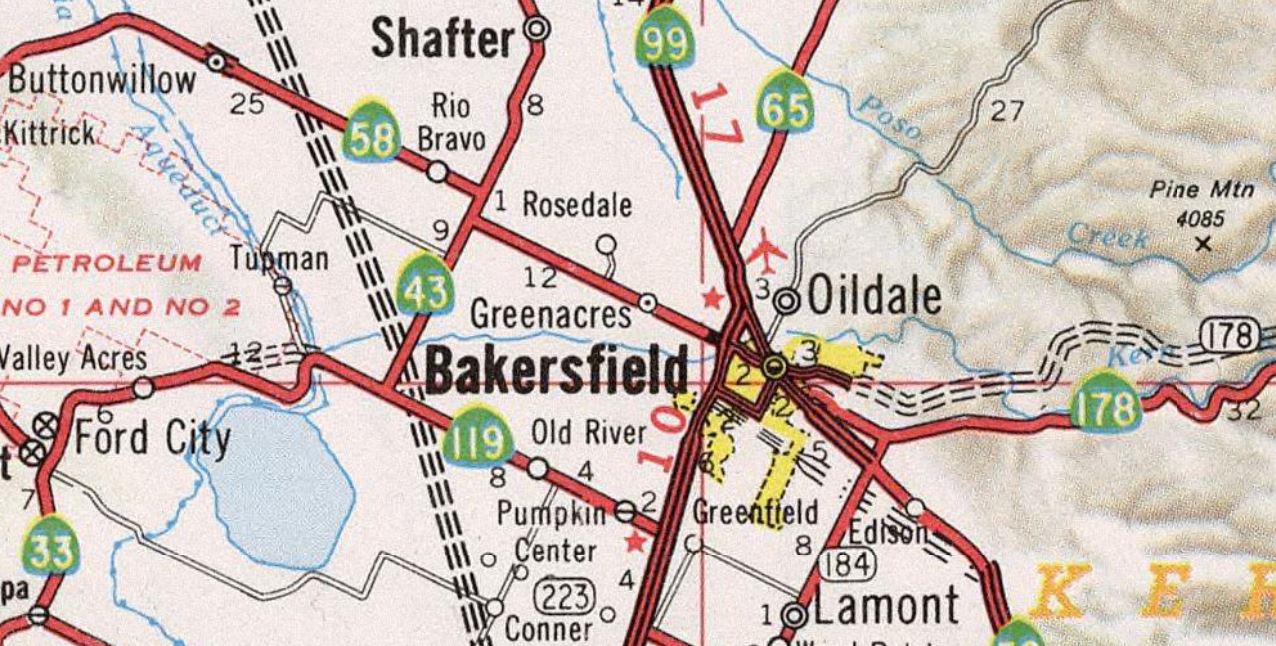
California State Route 58 was shifted to the Rosa Parks Freeway south of Brundage Lane during the mid 1970s. The realignment left California State Route 178 as the only Sign Route designation on 23rd Street/24th Street. The earlier surface routing on 24th Street from Golden State Avenue and N Street was reassigned as California State Route 178 Spur. The realignment of California State Route 58 and implied existence of California State Route 178 Spur can be seen for the first time on the 1977 Caltrans Map.

California State Route 178 would be truncated from California State Route 99 to M Street in 2011 which followed up on a relinquishment authorization of 24th Street and 23rd Street passed in 2006. California State Route 178 Spur was retained and appears in the Caltrans Postmile Tool on 24th Street west of Golden State Avenue to the vicinity of N Street.


Part 2; a drive on California State Route 178 Spur
California State Route 178 Spur begins via a westbound turn from California State Route 204/Golden State Avenue. California State Route 178 Spur is signed as "To California State Route 178."


California State Route 178 Spur westbound follows 24th Street to Q Street where it picks up the 23rd Street frontage road.


California State Route 178 Spur follows 24th Street under the mainline freeway towards N Street. California State Route 178 Spur consolidates with the mainline at N Street.


Westbound California State Route 178 terminates along 24th Street at M Street.


Comments