Madera County Road 600 is an approximately thirty-mile-long highway located in the Sierra Nevada Mountains. Road 600 begins at California State Route 49 near Ahwahnee and terminates to the south at Avenue 21. Road 600 historically was part of the Washburn Brothers Yosemite Stage Road to the Wawona Hotel and Yosemite Valley. Major waypoints along Road 600 include the ghost town of Grub Gulch and historic railroad terminus of Raymond.
Part 1; the history of Road 600
Road 600 is historically tied to the Wawona Road and Hotel. The Wawona Hotel is located near the Mariposa Grove in the modern southern extent of Yosemite National Park.
The origins of the Wawona Road are tied to the Wawona Hotel but it does predate the complex. The original trail over the South Fork Merced River was plotted out by the Mann Brothers in 1855. The initial toll crossing of the South Fork Merced River was simply a large log which was replaced by a primitive bridge known as "Clark's Crossing" soon after Galen Clark arrived in the area. Galen Clark settled near the South Fork Merced River hoping to cure his tuberculosis. In 1857 Clark along with Milton Mann were the first Europeans to locate the nearby Mariposa Grove of Redwood Sequoias. Clark spent the ensuing years attempting to bolster tourism to the Wawona area and the Mariposa Grove. These earliest efforts by Clark yielded a series of trails which became the earliest vestiges of the Wawona Road and Mariposa Grove Road.
The 1855 Bridge over the South Fork Merced River frequently washed out and often repaired. In 1862 the original South Fork Merced River Bridge was washed out again and the crossing was replaced by felled trees. In 1864 President Lincoln signed law which led to the protection of Yosemite Valley and the Mariposa Grove. In 1868 Galen Clark constructed a new bridge crossing the South Fork Merced River. Clark intended to build a road to Yosemite Valley but ultimately failed to do so. In 1875 Clark's Station and the rest of Clark's property was purchased by the Washburn Brothers who subsequently covered the 1868 Bridge which soon came to be known as the Wawona Covered Bridge. The Wawona Covered Bridge was part of the Wawona Road until a replacement span over the South Fork Merced River was built about 700 feet to the west.
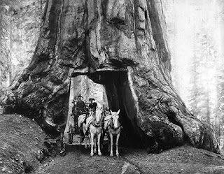
The first structure in the Wawona Hotel complex built by the Washburn Brothers complex dates back to 1876. At the time the Wawona Hotel was built to take advantage of tourism to the nearby Mariposa Grove via the Mariposa Grove Road. The name "Wawona" comes from a similar Mono Tribal word describing a Redwood Sequoia Tree. The Washburn Brothers completed the Wawona Road from their new Hotel to Yosemite Valley by 1879. In 1881 a tunnel was dug through the Wawona Tree in the Mariposa Grove to attract stages to drive through. In 1895 a second tunnel was carved through the California Tree in the Mariposa Grove. A stage wagon in the tunnel through the Wawona Tree can be seen on this 1904 photo.
Despite only being less than 30 miles south of Yosemite Valley the Wawona Hotel was several days away by foot through the wilderness. The Wawona Hotel was becoming popular and interest in a stage road north to Yosemite Valley was becoming a viable concept. Thus, the Yosemite Stage & Turnpike Company was founded in 1882 to facilitate stage route travel from the Wawona Hotel to Yosemite Valley.
The Yosemite Stage & Turnpike Company route took an alignment south/southwest from the Wawona Hotel complex to Madera via mining community of Grub Gulch. Grub Gulch developed after the opening of the Gambetta Mine in 1880. Grub Gulch obtained Post Office service during 1883 and reportedly may have had a population as high as 5,000 residents. Grub Gulch can be seen along the Yosemite Stage Road in a public domain photo from 1885.
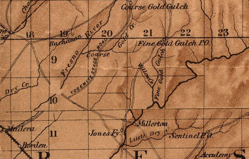
The Yosemite Stage Road can be seen connecting the Fresno Big Trees (Mariposa Grove) to Madera on the 1882 Bancroft's Map of California. The original Yosemite Stage Road passed through Fresno Flats (modern Oakhurst) and Coarsegold as it descended through the Sierra Nevada Mountains following much of the eastern bank of the Fresno River towards Madera. Much of this early iteration of the Yosemite Stage Road is now part of Road 400.


The Yosemite Stage Road became popular enough that it drew attention of the Southern Pacific Railroad for the development of a spur line out of Berenda. Raymond was founded as Wild Cat Station and was the north terminus of the San Joaquin Valley & Yosemite Railroad which was opened by the Southern Pacific Railroad in February 1886. The San Joaquin Valley & Yosemite Railroad received its first passengers by March of 1886, and the community of Wild Cat Station became a popular trailhead for stages heading to the Wawona Hotel and Yosemite National Park. Post Office was established in July of 1886, and the community's name was changed to Raymond. The name Raymond was chosen due to the community frequently being the used to ship materials from the nearby Raymond Granite Quarry. Raymond also had a substantial lumber shipping industry sourced by nearby Fresno Flats (modern Oakhurst). The San Joaquin Valley & Yosemite Railroad was shuttered in 1946.
The San Joaquin Valley & Yosemite Railroad and Yosemite Stage Road can be seen connecting Berenda siding north of Madera to Yosemite Valley on the
1891 Thompson Atlas of Fresno County. Major waypoints are shown to be Raymond, Grub Gulch, Fresno Flats and Mariposa Grove. A spur alignment of the Yosemite Stage Road over Miami Mountain is displayed north of Fresno Flats in Township 6S, Range 21E. Much of the Yosemite Stage Road north of Fresno Flats was located in Mariposa County. The 1886 alignment of the Yosemite Stage Road displayed from Raymond follows modern Road 600, California State Route 49, Road 628, Miami Mountain Road and California State Route 41 to the current boundary Yosemite National Park.
Madera County would split from northern Fresno County in 1893. This measure placed most of the Yosemite Stage Road into the boundaries of Madera County. The Yosemite Stage Road can be seen on the
1914 Madera County Survey Map between Berenda and the Mariposa County line north of Oakhurst.
The Yosemite Stage Road was under consideration as an addition to the State Highway System. The
February 1925 California Highways & Public Works announced a 61-mile survey corridor of the "Madera-Yosemite Big Trees Road" was recently completed. The survey was authorized by the State Legislature in 1921.
The
1935 Division of Highways Map of Madera County displays Raymond Road and Grub Gulch Road as major local highways. The former routing of the Yosemite Stage Road was replaced as the main highway to the Wawona area when Legislative Route Number 125 was commissioned during 1933. Legislative Route Number 125 was quickly developed through Oakhurst and was assigned as California State Route 41 during August 1934.
In time Madera County would drop road names in favor of a numbered system. Road 600 was assigned to Raymond Road between what is now Avenue 21 to Road 415 and Grub Gulch Road to Ahwahnee. The major north/south county roads in the Sierra Nevada Mountains seemingly were designated X00 numbers.
Part 2; a drive on Road 600
Road 600 southbound begins at California State Route 49 in Ahwahnee. Southbound Road 600 jogs towards the Fresno River where a historical plaque pertaining to Poison Switch and Enterprise Mine can be found. The Poison Switch was one of ten section houses on the 56-mile-long Madera Sugar Pine Lumber Flume.
Road 600 southbound climbs into the bluffs west of the Fresno River and then begins a gradual descent to the site of Grub Gulch. Post Office service ceased at Grub Gulch during 1918 and what remained of the community burned in 1920.
As Road 600 descends south through the Sierra Nevada Mountains a historical plaque regarding the Yosemite Stage & Turnpike Company can be found. The plaque notes service on the Yosemite Stage & Turnpike Company line in 1886 cost a lofty $45 (approximately $1,500 in modern money). The plaque notes the Yosemite Stage Route was rendered obsolete by the completion of the Yosemite Valley Railroad and later the Yosemite All-Year Highway (now California State Route 140).
Road 600 southbound intersects Road 810 (former Acton Grade) which can be used to access the ghost town of Bailey Flats at the East Fork Chowchilla River.
Road 600 continues descend south through the Sierra Nevada Mountains and intersects Road 415 near the outskirts of Raymond.
Road 600 enters Raymond and intersects Road 613. Road 613 can be utilized to reach Mariposa via Ben Hur Road.
Raymond still appears very much like what one would expect from a nineteenth town in the Sierra Nevada Mountains. The community features numerous historic buildings, plaques and even a train car from the San Joaquin Valley & Yosemite Railroad. Road 600 south of Raymond continues to Avenue 21 where the highway terminates.


.jpg)



Comments