Interstate 105 is an 18.82-mile freeway located in the Los Angeles Metropolitan Area. Interstate 105 begins at California State Route 1 in El Segundo and terminates to the east at Interstate 605 in Norwalk. Interstate 105 is developed over the conceptual corridor of the Century Freeway which was originally part of California State Route 42. Interstate 105 was completed by 1994 and is one of the last major urban Interstates to have been developed.
Part 1; the history of Interstate 105
The development of Interstate 105 and the Century Freeway is heavily tied to what was California State Route 42. California State Route 42 was originally designated as California State Route 10. More on California State Route 42 and California State Route 10 can be found below:
On June 29th, 1956, the Federal Highway Aid Act of 1956 was signed into law on the Federal Level. The Federal Highway Aid Act of 1956 was the genesis point of the Interstate Highway System. California State Route 10 (CA 10) was subsequently renumbered to CA 42 during 1960 to avoid duplication with Intestate 10. CA 42 first appears on the 1961 Division of Highways Map.
During the 1964 State Highway Renumbering all the Legislative Routes were dropped in favor of field signage. CA 42 was extended east from Downey via the unbuilt portion of Legislative Route Number 176 which was known as the Yorba Linda Freeway. CA 42 given a new Legislative Description as follows:
"Route 1 west of Inglewood to Route 91 in Santa Ana Canyon via the vicinity of Norwalk."
The planned alignment of CA 42 along with the new Legislative Description subsequently appear on the 1964 Division of Highways Map.
The Century Freeway alignment of CA 42 is first referenced in the March/April 1964 California Highways & Public Works. The article stub notes that the Century Freeway was discussed via public hearing on June 5th, 1963.
The March/April 1964 California Highways & Public Works references the first segment of the Yorba Linda Freeway (CA 42) between Orangethorpe Avenue and Yorba Linda Avenue had opened to traffic during February of 1963.
During 1965 the unbuilt portion of CA 42 from Interstate 605 to CA 39 was transferred to CA 90. CA 42 was subsequently given a new Legislative Definition:
"(1) fromt Route 1 west of Inglewood to Route 605 and (2) Route 39 near La Habra to Route 91 in Santa Ana Canyon."
The gapped legislative definition of CA 42 first appears on the 1966 Division of Highways Map along with the planned alignment of the Century Freeway.
The Century Freeway (CA 42) is detailed in the January/February 1966 California Highways & Public Works in a recap of September/October 1965 actions by the California Highway Commission. An 8.4-mile route adoption of the Century Freeway/CA 42 from CA 1 near Los Angeles International Airport east to Central Avenue in Los Angeles is cited.
The adopted alignment of the Century Freeway/CA 42 from CA 1 to Central Avenue along with the planned continuation to CA 19 appears on the 1967 Division of Highways Map.
The Century Freeway was approved to be added as a chargeable Interstate during March of 1968. The addition of the Century Freeway to the Interstate Highway System was made possible due to 17 miles of chargeable Interstate being freed elsewhere in California. The Century Freeway was assigned as the second iteration of Interstate 105 which was reflected in the Legislative Definition of CA 42 being transferred. Segment (A) of CA 42 was reassigned to the Legislative Definition of Interstate 105 whereas Segment (B) was reassigned to CA 90. 1968 Legislative Chapter 282 defined Interstate 105 as "Route 1 west of Inglewood to Route 605."
The planned route of the Century Freeway appears as Interstate 105 on the 1969 Division of Highways Map. Existing CA 42 on Manchester Boulevard and Firestone Boulevard is shown to also be legislatively Route 105.
According to CAhighways.org a class action lawsuit was filed during 1972 to block construction of the Century Freeway. As a result of the lawsuit all work of the Century Freeway was halted and numerous impact surveys were ordered. The class action lawsuit against the Century Freeway was settled consent degree during 1979. Cost estimates for construction of the Century Freeway had substantially risen during the 1970s which led to some scaling back of the scope of Interstate 105 (namely two planned lanes were dropped). An amended consent degree for the Century Freeway approved by court order during 1981. 1981 Legislative Chapter 292 changed the western terminus of Interstate 105 to; "The south boundary of the Los Angeles International Airport near El Segundo."
The new western terminus of Interstate 105 at El Segundo first appears on the 1982 Caltrans Map.
Caltrans was pressured by the Federal Highway Administration of Interstate 105 and the Century Freeway prior to 1986 given it was a chargeable Interstate. Initial work on Interstate 105 and the Century Freeway would begin during 1982 but would progress slowly. 1992 Legislative Chapter 1243 changed the western terminus of Interstate 105 to; "Pershing Drive near El Segundo." The planned corridor of Intestate 105 along with existing CA 42 can be viewed on the 1990 Caltrans Map.
The first segment of Interstate 105 opened during 1993 and the highway would be fully completed during 1994. Despite locally being known as the Century Freeway due to the proximity of Century Boulevard the entirety of Interstate 105 has been officially known as the Glenn Anderson Freeway since 1987. The official names of the Century Freeway designated during 1969 was "El Segundo Freeway" west of Interstate 405 and "Norwalk Freeway" east of Interstate 405. Following the completion of Interstate 105 led to the relinquishment of all of CA 42 on Manchester Boulevard and Firestone Boulevard.
Interstate 105 is probably most well-known from the 1994 action movie Speed and the infamous bus jumping a freeway exit gap scene.
The thoughts of the Los Angeles Police Department in Speed regarding delays in the completion Interstate 105 can be seen below.
Part 2; Roadwaywiz on Interstate 105
During May 2020 Interstate 105 was featured as part of the Roadwaywiz Los Angeles Webinar. Interstate 105 is discussed by panelists Dan Murphy, Scott Onson and Steve Alps at 27:00-33:42.
Part 3; scenes along Interstate 105
Pictured is Interstate 605 northbound approaching Interstate 105. Traffic along Interstate 605 cannot access the easternmost segment of Interstate 105 which ends at Studebaker Road in Norwalk. The eastern terminus of Interstate 105 is accessible from the eastbound freeway and west from Studebaker Road.
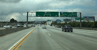
Pictured is westbound Interstate 105 approaching Interstate 710. Interstate 105 and Interstate 710 intersect near the Los Angeles River in Lynwood.
Pictured is westbound Interstate 105 approaching Interstate 110 at the Judge Harry Pregerson Interchange. The bus mentioned above in Speed would have turned from westbound Interstate 105 onto the northbound general service ramp to Interstate 110.
Pictured is westbound Interstate 105 approaching Interstate 405 at the Sadao S. Munemori Memorial Interchange.
Grand Loop Road is a 140 mile loop highway which traverses the interior of Yellowstone National Park. Grand Loop Road connects all of the major attractions and geological features of Yellowstone National Park along with the entrance roads. Grand Loop Road is a seasonal highway and despite some conjecture never has been part of the US Route System. Part 1; the history of Grand Loop Road The majority of history pertaining to Grand Loop Road was taken from the below National Park Service article: Historic Roads - Yellowstone National Park (U.S. National Park Service) (nps.gov) Yellowstone was declared the first National Park of the United States on March 1st, 1872. The first real highway to access Yellowstone National Park came in 1873 when a tolled facility was constructed from Bozeman, Montana via Yankee Jim Canyon to Mammoth Hot Springs. Numerous attempts were made to fund construction of roadway infrastructure during the early years of Yellows...
Along southbound California State Route 170 (the Hollywood Freeway Extension) approaching the Hollywood Freeway/Ventura Freeway interchange a white California State Route 134 Sign State Route Spade can be observed on guide sign. These white spades were specifically used during the 1956-63 era and have become increasingly rare. This blog is intended to serve as a brief history of the Sign State Route Spade. We also ask you as the reader, is this last 1956-63 era Sign State Route Spade or do you know of others? Part 1; the history of the California Sign State Route Spade Prior to the Sign State Route System, the US Route System and the Auto Trails were the only highways in California signed with reassurance markers. The creation of the US Route System by the American Association of State Highway Officials during November 1926 brought a system of standardized reassurance shields to major highways in California. Early efforts to create a Sign State Route ...
From 2017 through to early 2019 I drove the majority of the California State Route 70; the Feather River Highway from CA 89 southwest to CA 99. CA 70 is an approximately 178.5 mile state highway which starts at US 395 near the Nevada State Line and travels west through the Feather River Canyon to CA 99. CA 70 is often referred to as the Feather River Highway" given it's close association with the river. Historically CA 70 was previously signed as US 40A and CA 24. The Legislative Routes prior to the 1964 California Highway Renumbering that made up the current route of CA 70 are as follows: - Legislative Route Number 21 from US 395 westward to Oroville. - LRN 87 from Oroville south to Marysville. - LRN 232 from Marysville to the current junction with CA 99. CA 70 was even dual signed with CA 99 into Sacramento on what was LRN 232 for a time. The change from US 40A/LRN 21/LRN 87/LRN 232 can be seen by comparing the 1963 State Highway Ma...


Comments