

Nestled in the scenic
hills of northeast Pennsylvania, the Starrucca Viaduct is a 19th
Century railroad bridge known for its historic design and its impressive
longevity. Opened in 1848, it was known as the world's largest stone-arch railroad viaduct as it carried
traffic along the original New York & Erie Railroad. It has been suggested
that this bridge was the first in America to utilize structural concrete in its
construction, the material being utilized for the bridge’s foundations. In the
mid-1800s, concrete was still an unknown quantity as a material and it was
still considered to be experimental in nature at the time, making its use at
this location a daring yet critical first step in the material’s evolution into
a building block that modern construction could never be without.
This bridge’s size and design anticipated the construction of a
more-famous stone arch railroad bridge built about 25 years later in England.
The Ribblehead Viaduct in North Yorkshire, England is one of the most popular
historic bridges for enthusiasts alike and its own proportions were likely
inspired at least in part by its American counterpart here in Pennsylvania. As
a result, the Starrucca Viaduct is sometimes known as the “American Ribblehead”,
as it comes the closest to resembling its English rival in size and form. As
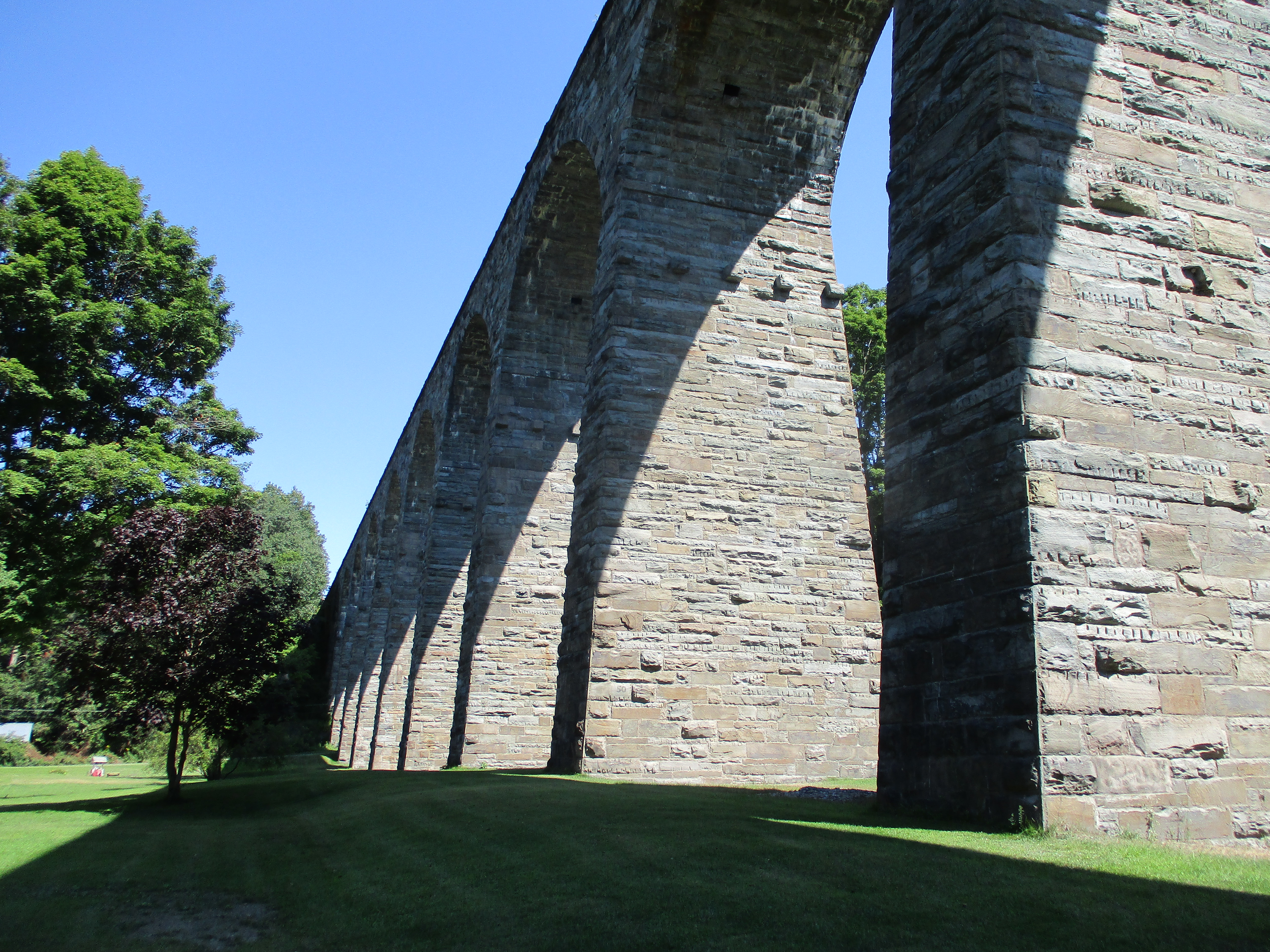
for this structure, it spans the wide Starrucca Creek Valley, requiring a span
of about a thousand feet in length. The whole structure above ground was build
of locally-quarried ashlar bluestone and the entire project was put together in
about one year – an impressive timeline for a structure of its kind. It
measures 1,040 ft in length, stands (on average) about 100 ft tall, and
consists of seventeen arch spans each measuring 50 ft long. While build wide enough
for a dual-track deck layout, it has spent most of its life as a single-track crossing
that has been structurally reinforced and upgraded in a subtle manner over the
years.


The Viaduct remains in
active use today (owned by the Delaware-Otsego Corporation and operated by the
New York, Susquehanna, & Western Railway on its Port Jervis to Binghamton
service), more than 150 years after its construction, making it one of the
oldest active railroad bridges in the nation. The American Society of Civil
Engineers recognizes the historic significance of its design & construction
with its designation as a National Civil Engineering Landmark, in addition to
its place on the National Register of Historic Places.
Most people have no
problem taking in the sight of this structure from ground level, but back in
mid-2020 I had the opportunity to go one step further and see what it looks
like from the air; this was a great location for a quick workout session with
my quadcopter drone – the perspectives you get from the air add a whole new
dimension to our understanding of this bridge’s proportions and its place
within the scenic surrounding valley. If you’re ever in the area, or “just
passing through” (as my podcasting alter ego would say), this one is worth
stopping by to check out – it’s a rare American example of the stone arch
design taken to greater lengths. It can be reached from Interstate 81 by taking
Exit 230 and following PA 171 about 10 miles east, passing through the village
of Susquehanna (along the river of same name) in the process. Who knows, if you
end up visiting, maybe you’ll run in to me – I hope to come back here at some
point to add to my portfolio at this location…


Above: Various aerial views of the Viaduct courtesy of my quadcopter drone. If you do bring a drone here, please be safe and fly responsibly!
More information from ASCE website
More information from Pennsylvania Center for the Book website
Comments