Ghost Town Tuesday; the ghost towns of Indiana Dunes National Park and State Park (City West and Baileytown)
Recently while visiting Indiana I stopped at Indiana Dunes National Park and Indiana Dunes State Park to find a couple ghost towns; City West and Baileytown.

The Indiana Dunes are notable not only for being scenic and recently being included as a full fledged National Park. During the 19th Century the Indiana Dunes were host to several failed attempts to organize communities along the south shore of Lake Michigan.
City West was located in what is now Porter County along Dunes Creek of Indiana Dunes National Park just past the north terminus of Indiana State Route 49. City West was settled on the former location of the fur trading post of Petit Fort which had been demolished in 1780. City West was meant to be a rival port to nearby Chicago and investors plotted out twenty five blocks in 1836. City West apparently had as many as forty homes, a pier and even a saw mill built between 1835 to 1837. Investor panic in 1837 caused most of City West to be abandoned and the site was considered a ghost town by late 1839. City West reportedly burned to the ground in 1854 due to wildfire and the last trace of the community was the pier which lasted until the 1870s. More information on the back story of City West can be found at inportercounty.com.
inportercounty.com on City West
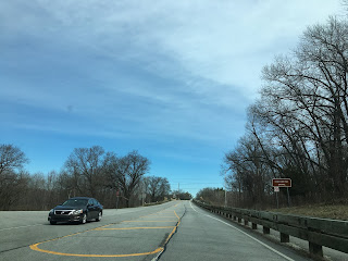
City West is located within the boundary of Indiana Dunes State Park just past the north terminus of IN 49. Interestingly IN 49 for unknown reasons sports a retro shield at it's north terminus. The main park road of Indiana Dunes State Park leads straight to the location of City West on the shore of Lake Michigan at Dunes Creek.



The location of City West while not containing any remaining structures is easily recognizable by the site of the boarded up shelter along Dunes Creek.

From the mouth of Dunes Creek the City of Chicago can be seen to the northwest. It is hard to envision someone really thinking that a port located on a massive dune could possibly rival Chicago.


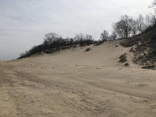
The site of City West is host to several shore line and dune trails. The Indiana Dunes formation are stabilized by rapid plant growth, similar formations can be found all across Lake Michigan.



The community of Baileytown was located to the west of high dunes of Indiana Dunes State Park in the National Park lands just south of US 12 along the Little Calumet River. Baileytown as a town site was plotted in 1833 by French Canadian Fur Trader Joseph Bailey near his trade post but it was ultimately never actually constructed. Baileytown was the last stage stop for travelers heading west towards Chicago via the south shore of Lake Michigan. Baileytown became the common name for the Bailey trading post which was active into the 1870s when much of the land was sold to local ranchers. Some of the land around what was Baileytown has been incorporated into the Dunes Learning Center. I'm uncertain of the vintage of some of the buildings in the Dunes Learning Center but they seem to be from the late 19th Century.


The Indiana Dunes are notable not only for being scenic and recently being included as a full fledged National Park. During the 19th Century the Indiana Dunes were host to several failed attempts to organize communities along the south shore of Lake Michigan.
City West was located in what is now Porter County along Dunes Creek of Indiana Dunes National Park just past the north terminus of Indiana State Route 49. City West was settled on the former location of the fur trading post of Petit Fort which had been demolished in 1780. City West was meant to be a rival port to nearby Chicago and investors plotted out twenty five blocks in 1836. City West apparently had as many as forty homes, a pier and even a saw mill built between 1835 to 1837. Investor panic in 1837 caused most of City West to be abandoned and the site was considered a ghost town by late 1839. City West reportedly burned to the ground in 1854 due to wildfire and the last trace of the community was the pier which lasted until the 1870s. More information on the back story of City West can be found at inportercounty.com.
inportercounty.com on City West
City West is located within the boundary of Indiana Dunes State Park just past the north terminus of IN 49. Interestingly IN 49 for unknown reasons sports a retro shield at it's north terminus. The main park road of Indiana Dunes State Park leads straight to the location of City West on the shore of Lake Michigan at Dunes Creek.


The location of City West while not containing any remaining structures is easily recognizable by the site of the boarded up shelter along Dunes Creek.

From the mouth of Dunes Creek the City of Chicago can be seen to the northwest. It is hard to envision someone really thinking that a port located on a massive dune could possibly rival Chicago.


The site of City West is host to several shore line and dune trails. The Indiana Dunes formation are stabilized by rapid plant growth, similar formations can be found all across Lake Michigan.


The community of Baileytown was located to the west of high dunes of Indiana Dunes State Park in the National Park lands just south of US 12 along the Little Calumet River. Baileytown as a town site was plotted in 1833 by French Canadian Fur Trader Joseph Bailey near his trade post but it was ultimately never actually constructed. Baileytown was the last stage stop for travelers heading west towards Chicago via the south shore of Lake Michigan. Baileytown became the common name for the Bailey trading post which was active into the 1870s when much of the land was sold to local ranchers. Some of the land around what was Baileytown has been incorporated into the Dunes Learning Center. I'm uncertain of the vintage of some of the buildings in the Dunes Learning Center but they seem to be from the late 19th Century.


Comments