This past week I just took California State Route 1 south from Monterey to CA 46 near Cambria for the first time since the Mud Creek Slide reopened on July 18th. The Mud Creek Slide was the final major slide and the biggest even along CA 1 in Big Sur occurring on May 20th of 2017. Previously in February the 60 inches of rain over the 2017 winter took their toll and caused the Pfeiffer Canyon Bridge to be condemned in addition to Paul's Slide near Lucia. By the end of May 2017 the situation for CA 1 in Big Sur was extremely grim with access to the communities of Gorda and Lucia having access to the outside world via an easterly trek over the Santa Lucia Range on the one-lane Nacimiento-Fergusson Road.
Given the situation out on CA 1 in Big Sur was very unique I decided that I want to document as much as I could. I started with what was often touted as something ill advised; taking the Nacimiento-Fergusson Road west over the Santa Lucia Range to the isolated section of CA 1 in Big Sur.

This blog is sort of meant to be a side story to the Mud Creek reopening CA 1 blog that I just published:
California State Route 1; Mud Creek Slide reopens
The Nacimiento-Fergusson Road is an approximately 24 mile road running from Mission Road in Fort Hunter Liggett westward to CA 1. Most of the Nacimiento-Fergusson Road is maintained by Los Padres National Forest and is one-lane. The Nacimiento-Fergusson Road is well maintained for a Forest Route but has massive downhill grades on the western descent from the Santa Lucias to CA 1.
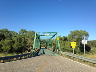
The Nacimiento-Fergusson Road starts with this one large bridge over the San Antonio River. Bridgehunter.com didn't have any information on this bridge but it appears to be somewhat old, the design capacity is probably huge due to the Army training grounds Interestingly there is a tank bypass just to the left of the bridge in this picture.
Nacimiento-Fergusson is a two-lane well maintained road west through Fort Hunter Liggett to the Los Padres National Forest line. There is a large gate at the National Forest Boundary that is closed when training exercises are occurring at Fort Hunter Liggett.


Nacimiento-Fergusson drops to a wide single lane and remains that way all the way west to the coast from here on out. Again there is a new "30 Foot" advisory sign.

It isn't too long until the Nacimiento-Fergusson Road picks up the namesake river at about an elevation of 1,400 feet above sea level.

There is virtually no elevation change for the next couple westward miles until this single lane crossing of the Nacimiento River. The Nacimiento-Fergusson Road begins to ascend to the 2,777 foot summit from here.

About a mile or two from the summit there is a really nice overlook of the Santa Lucia Range.

At the unnamed 2,777 foot summit there was a sign saying CA 1 is closed six miles ahead to all but local traffic. The sign wasn't accurate as several miles of the high in both north/south directions were open to general traffic.

A couple hundred feet west of the summit is the first view of the ocean and the expanse below.

From here west there are occasional narrow sections where someone would have to back up if two cars met. That said, they are brief and it is highly unlikely that an encounter would cause too much of an issue in regards to finding a place to pass.

The roadway really hugs the terrain pretty closely which leads to a lot hairpins and blind curves.

At about 2,100 feet is the first real chance to see what is westward and far below.

There is a second overlook a little to the west which shows the road cut a little more clearly. It is a steady and steep drop for the next mile or two ahead with grades up to 14%.

In February of 2017 even the Nacimiento-Fergusson Road was closed by a slide. It wasn't until the roadway was cleared that Gorda and Lucia had road access to the outside world. The road dogs north briefly away from the cliff-face which was where the slide from was located.


Given the situation out on CA 1 in Big Sur was very unique I decided that I want to document as much as I could. I started with what was often touted as something ill advised; taking the Nacimiento-Fergusson Road west over the Santa Lucia Range to the isolated section of CA 1 in Big Sur.

This blog is sort of meant to be a side story to the Mud Creek reopening CA 1 blog that I just published:
California State Route 1; Mud Creek Slide reopens
The Nacimiento-Fergusson Road is an approximately 24 mile road running from Mission Road in Fort Hunter Liggett westward to CA 1. Most of the Nacimiento-Fergusson Road is maintained by Los Padres National Forest and is one-lane. The Nacimiento-Fergusson Road is well maintained for a Forest Route but has massive downhill grades on the western descent from the Santa Lucias to CA 1.
The Nacimiento-Fergusson Road starts with this one large bridge over the San Antonio River. Bridgehunter.com didn't have any information on this bridge but it appears to be somewhat old, the design capacity is probably huge due to the Army training grounds Interestingly there is a tank bypass just to the left of the bridge in this picture.

Nacimiento-Fergusson is a two-lane well maintained road west through Fort Hunter Liggett to the Los Padres National Forest line. There is a large gate at the National Forest Boundary that is closed when training exercises are occurring at Fort Hunter Liggett.


Nacimiento-Fergusson drops to a wide single lane and remains that way all the way west to the coast from here on out. Again there is a new "30 Foot" advisory sign.

It isn't too long until the Nacimiento-Fergusson Road picks up the namesake river at about an elevation of 1,400 feet above sea level.

There is virtually no elevation change for the next couple westward miles until this single lane crossing of the Nacimiento River. The Nacimiento-Fergusson Road begins to ascend to the 2,777 foot summit from here.

About a mile or two from the summit there is a really nice overlook of the Santa Lucia Range.

At the unnamed 2,777 foot summit there was a sign saying CA 1 is closed six miles ahead to all but local traffic. The sign wasn't accurate as several miles of the high in both north/south directions were open to general traffic.

A couple hundred feet west of the summit is the first view of the ocean and the expanse below.

From here west there are occasional narrow sections where someone would have to back up if two cars met. That said, they are brief and it is highly unlikely that an encounter would cause too much of an issue in regards to finding a place to pass.

The roadway really hugs the terrain pretty closely which leads to a lot hairpins and blind curves.

At about 2,100 feet is the first real chance to see what is westward and far below.
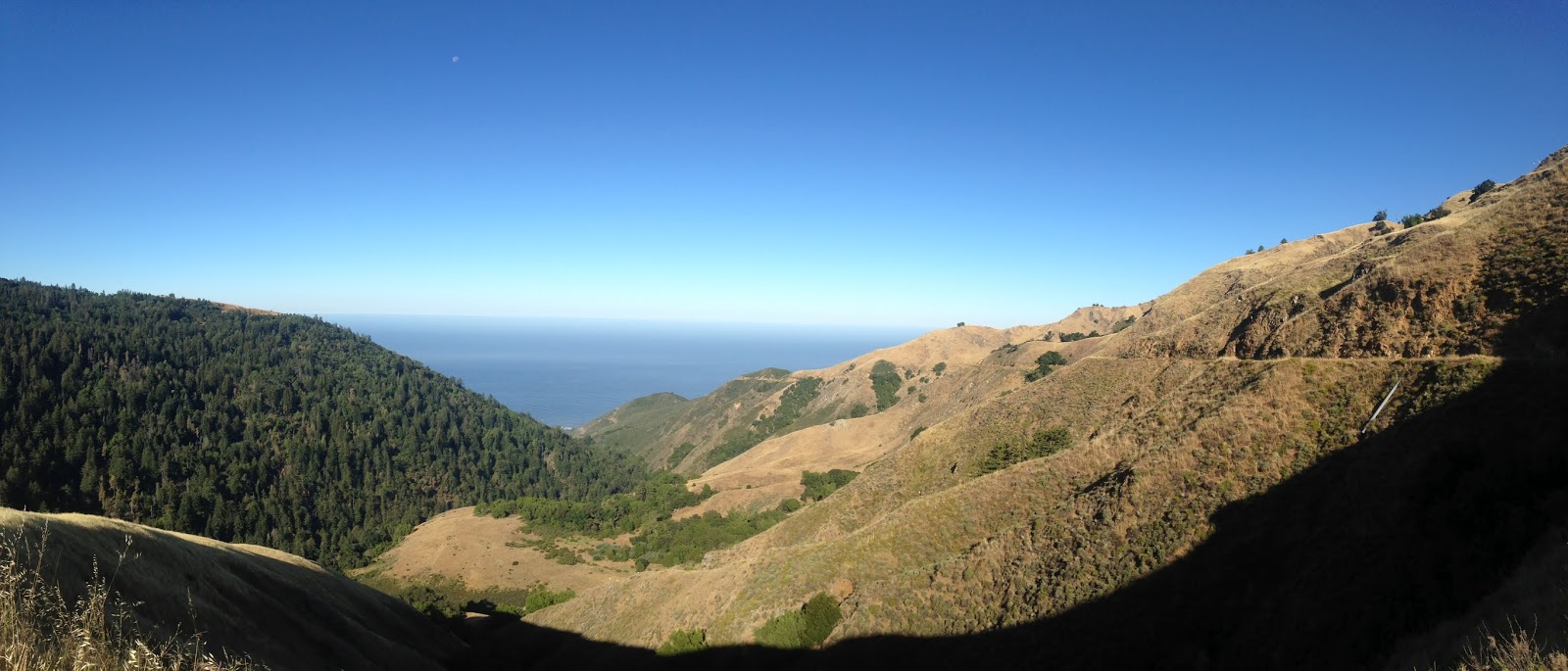
There is a second overlook a little to the west which shows the road cut a little more clearly. It is a steady and steep drop for the next mile or two ahead with grades up to 14%.

In February of 2017 even the Nacimiento-Fergusson Road was closed by a slide. It wasn't until the roadway was cleared that Gorda and Lucia had road access to the outside world. The road dogs north briefly away from the cliff-face which was where the slide from was located.


West of the construction zone is where the big grades start at about
1,700 feet above sea level, the 14% grades are within this area.

Which is illustrated by how much the roadway drops by looking at it from above.

The Nacimiento-Fergusson Road dogs north for a bit facing towards a hell of a view of Paul's Slide.

The road dogs back south after this hairpin and essentially is located directly above CA 1.


I found this attempt at a center stripe to be somewhat amusing.

The roadway curves back east from here on nearing the final descent.

Which offers a nice view of the canyon just traversed above.

After another hairpin the road is facing west again towards the ocean.

Before the last swing north to CA 1 there are some fantastic views of it
from a pull-out. It was kind of amazing to see the Pacific Coast
Highway with no cars on it and no noise aside from the ocean
below.

With final drop Nacimiento-Fergusson reaches CA 1. The road was
open three miles to the north and it says eight miles to the south but
it was actually slightly further.


I drove north to Limekiln State Park just outside the gate for the closure at Paul's Slide.


The gate for Paul's Slide at Limekiln State Park was manned to allow locales through and Caltrans work crews. At the time Paul's Slide was slated to be reopened to all traffic the following month.

The trails in Limekiln State Park are all jacked up and washed out from
tree debris. I did manage to get up to Limekiln Falls by using the tree
debris, the Lime Kiln trail was wiped out by a fallen redwood.

The beach on the other hand was easily accessible and had great views of the ocean in addition to the highway bridge.


At the time Caltrans was stating CA 1 southbound was only open as far as Plaskett but it was actually open to Gorda.

The contradiction was evidenced by the fact this VMS says 9 Miles approximately 1 mile south of Nacimiento-Fergusson Road.

I didn't encounter another passenger car heading south, only stray
Caltrans workers cleaning up the road. Made for some great shots of an
empty highway and made it easy to get up to 60 MPH.


The Willow Creek Bridge is where Caltrans was posting the southbound closure for Mud Creek.

But Gorda was very reachable.

The Mud Creek Slide was approximately 1 mile south of Gorda which is why the gate was located in the community.

The Nacimiento-Fergusson Road first appears on State Highway Maps in 1938 and appears to have been built to access the CA 1 which was completed by 1937.
According to pjammycycling the western most 6.7 miles of the
Nacimiento-Fergusson Road to CA 1 has the following grade statistics:
Distance
6.7
Average Grade
7.20%
Elevation Gained
2,609
Descended
(62)
Beginning Elevation
237
Ending Elevation
2,777
Max Grade
14.1%
I've found this site to be very reliable for finding out what grades since he uses a grade meter to measure the roadways. Really it is pretty helpful information in California in general since that kind of information is difficult to come by from Caltrans or any sort of governing body maintaining a roadway. The site can be found here:
Distance
6.7
Average Grade
7.20%
Elevation Gained
2,609
Descended
(62)
Beginning Elevation
237
Ending Elevation
2,777
Max Grade
14.1%
I've found this site to be very reliable for finding out what grades since he uses a grade meter to measure the roadways. Really it is pretty helpful information in California in general since that kind of information is difficult to come by from Caltrans or any sort of governing body maintaining a roadway. The site can be found here:
Comments