After completing California State Route 155 and CA 202 I found myself near Tehachapi Pass. That being the case I trip back down to the Central Valley on CA 58 would have been mundane so I opted for the routing of US Route 466 to through Bakersfield.

This is the 2nd Part to the US Route 466 Legacy Series. The first entry covered California State Route 46 and the overall history of US 466.
Legacy of US Route 466 Part 1; California State Route 46
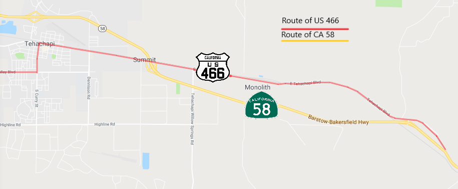
The routing of US 466 compared to modern CA 58 is substantially different from Tehachapi west to Bakersfield. Heading westward US 466 would have diverged from CA 58 onto Tehachapi Boulevard passing through the community of Monolith before entering the city of Tehachapi proper. Within Tehachapi US 466 turned south on Curry Street and west on Valley Boulevard.

Since I was on CA 202 I started my trek on the routing of US 466 at Valley Boulevard and Tucker Road.


US 466 diverged from Valley Boulevard and CA 202 at Woodford-Tehachapi Road heading northward which would be on the right in the photo below.

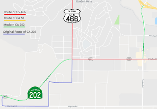
Originally CA 202/Legislative Route 144 would have started heading south from US 466 on Woodford-Tehachapi Road. This map illustrates how differently CA 202/LRN 144 is today compared to the original routing.
Woodford-Tehachapi Road heads directly north through Old Town Tehachapi. Tehachapi was originally located west of the current city site on the Union Pacific Railroad near mining claims located in the 1850s. Tehachapi was founded in 1869 but may have gone by Williamsburg or Tehichipa originally. The creation of the Tehachapi Loop and Tehachapi Grade in 1876 spurred the community to move to the present site to take advantage of railroad lines.


This motel is located on Woodford-Tehachapi Road near Old Town Road. It totally has the feel of an old US Route era motel.

North of Old Town Road traffic on Woodford-Tehachapi Road has a posting that trucks are not recommended.

Woodford-Tehachapi Road begins to curve up and emerges on a cliff above the Union Pacific Lines in addition CA 58 below.


I always found the Woodford-Tehachapi Road routing of US 466 surprising considering the terrain north of the railroad below appears to have been something that could have had a road easily alongside. According to CAhighways.org when LRN 58 west extended west of Mojave in 1931 it used the existing county roads through Tehachapi Pass. I suspect that Kern County was probably not interested in creating a large railroad crossing on the Tehachapi Grade and routed the roadway above it to the south. Considering the importance US 466 ultimately ended up having to commercial truck traffic it is interesting that the route was never improved through Tehachapi Pass before it swapped for CA 58 during the 1964 State Highway Renumbering.
CAhighways.org on LRN 58
The high grade of US 466 on Woodford-Tehachapi Road is obvious looking westward towards the Tehachapi Loop.

It should be noted that Woodford-Tehachapi Road is now Kern County Road 481Y and is well postmiled.

From certain corners tunnels from the Tehachapi Grade can be spied below.


US 466 passed by the Tehachapi Loop on Woodford-Tehachapi Road.

As noted above the Tehachapi Loop and Tehachapi Grade were completed in 1876. The Southern Pacific Railroad (part of the modern Union Pacific) used Chinese Laborers to build the Tehachapi Loop and 28 Mile Grade in only two years. Tehachapi Pass had been a well known and reliable all-year pass all the way back to the 2nd Fremont Expedition in 1844.


Tehachapi Pass was the second rail crossing of the Sierras after the First Trans-Continental Railroad had been built through Donner Pass. Getting a railroad on a 2.2% grade through Tehachapi Pass required the 0.77 mile long Tehachapi Loop to be built.

The Tehachapi Loop sees about 40 trains a day which is an absolute riot to watch from Woodford-Tehachapi Road.


Woodford-Tehachapi Road drops to the Union Pacific Railroad and crosses under CA 58.


Woodford-Tehachapi Road passes by the Chavez Center which is now part of Cesar Chavez National Monument. The property was the home of Cesar Chavez until his death in 1993 and was the headquarters for the United Farm Workers.


Woodford-Tehachapi Road passes through Keene before dead-ending at the CA 58 expressway. US 466 traffic would have continued over lanes that are now part of the expressway westward to Bena Road.


These maps below illustrates the difference in CA 58 compared to the alignments US 466 used on Woodford-Tehachapi Road west to Bena Road.


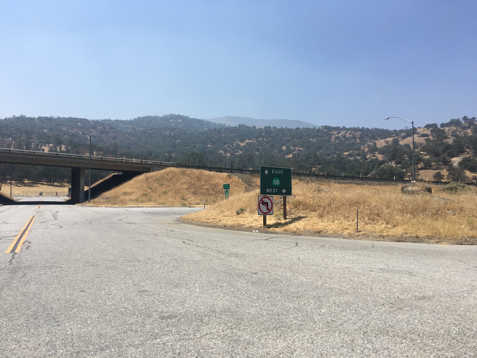
Bena Road starts at the CA 58 junction with Bealville Road. US 466 would have followed Bena Road westward as it crosses under the grade of CA 58.


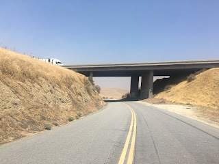

Interestingly Bear Mountain which is 6,916 feet above sea level can be seen from Bena Road at the CA 58 underpass.

Bena Road is now maintained as Kern County Road 226H.

Bena Road and US 466 followed Caliente Creek into San Joaquin Valley. The canyon grades are really quite good and very well maintained. I'm to understand that the wooden guard rails might be original California Division of Highway construction back to the US 466 era.


Bena Road climbs a large bluff and splits away from Caliente Creek.


At Tower Line Road the designation of Bena Road changes to Edison Highway. US 466 continued west through the community of Edison on Edison Highway.


West of Edison the alignment of US 466 on Edison Highway met LRN 143 at Weedpatch Highway. Weedpatch Highway is now signed as CA 184.


At this at-grade railroad crossing US 466 on Edison Highway would have entered the City of Bakersfield.

US 466 made a turn towards downtown Bakersfield on Sumner Street.

This map below visually shows the alignment of US 466 on Bena Road, Edison Highway, and Sumner Street.

Originally US 466 would have met CA 178 on Sumner Street at Beale Avenue at an at-grade intersection. CA 178 would have multiplexed US 466 west to 24th Street, today Beale Avenue is on a fly-over grade.

At Union Avenue/Golden State Avenue US 466 met US 99 and US 399. US 399 had a northern terminus multiplexed on US 99 directly to the left on Union Avenue. US 466 would have split right on US 99 via Golden State Avenue, CA 178 would have followed to 24th Street until it was realigned in 1963.

US 466 and US 399 oddly never had alignment shifts through downtown Bakersfield. US 99 and CA 178 shifted course various times, this map below is a quick illustration showing them all in one photo.

US 99/466 multiplexed through Bakersfield on Golden State Avenue on what is now the routing of CA 204 to CA 99.


From the end of CA 204 the alignment of US 466 followed US 99 on what is now the CA 99/Golden State Freeway to Famoso. Much of the Golden State Freeway north to Fresno was built upon the original alignments of US 99. From Famoso US 466 cut west on what is now modern CA 46 which was covered in Part 1.
US 466 from Tehachapi west to Bakersfield wasn't upgraded to an expressway/freeway until it was renumbered to CA 58. To that end the US 466 became an extremely important corridor even from I-15/I-40 in Barstow and has seen continuing improvements, most recently with the Hinkley Bypass. The Kramer Junction bypass will be the last section of US 466 between Bakersfield and Barstow to be replaced, to that end I'll probably cover that particular project some time in 2019.
The entire alignment of US 466 as it was in Kern County can be viewed on this 1935 California Division of Highways Map.

Update 10/2/19: This past weekend I revisited Tehachapi and drove former US 466 from CA 58 east on Tehachapi Boulevard towards the Sand Canyon Road exit.


This is the 2nd Part to the US Route 466 Legacy Series. The first entry covered California State Route 46 and the overall history of US 466.
Legacy of US Route 466 Part 1; California State Route 46
The routing of US 466 compared to modern CA 58 is substantially different from Tehachapi west to Bakersfield. Heading westward US 466 would have diverged from CA 58 onto Tehachapi Boulevard passing through the community of Monolith before entering the city of Tehachapi proper. Within Tehachapi US 466 turned south on Curry Street and west on Valley Boulevard.
Since I was on CA 202 I started my trek on the routing of US 466 at Valley Boulevard and Tucker Road.


US 466 diverged from Valley Boulevard and CA 202 at Woodford-Tehachapi Road heading northward which would be on the right in the photo below.

Originally CA 202/Legislative Route 144 would have started heading south from US 466 on Woodford-Tehachapi Road. This map illustrates how differently CA 202/LRN 144 is today compared to the original routing.

Woodford-Tehachapi Road heads directly north through Old Town Tehachapi. Tehachapi was originally located west of the current city site on the Union Pacific Railroad near mining claims located in the 1850s. Tehachapi was founded in 1869 but may have gone by Williamsburg or Tehichipa originally. The creation of the Tehachapi Loop and Tehachapi Grade in 1876 spurred the community to move to the present site to take advantage of railroad lines.


This motel is located on Woodford-Tehachapi Road near Old Town Road. It totally has the feel of an old US Route era motel.

North of Old Town Road traffic on Woodford-Tehachapi Road has a posting that trucks are not recommended.

Woodford-Tehachapi Road begins to curve up and emerges on a cliff above the Union Pacific Lines in addition CA 58 below.


I always found the Woodford-Tehachapi Road routing of US 466 surprising considering the terrain north of the railroad below appears to have been something that could have had a road easily alongside. According to CAhighways.org when LRN 58 west extended west of Mojave in 1931 it used the existing county roads through Tehachapi Pass. I suspect that Kern County was probably not interested in creating a large railroad crossing on the Tehachapi Grade and routed the roadway above it to the south. Considering the importance US 466 ultimately ended up having to commercial truck traffic it is interesting that the route was never improved through Tehachapi Pass before it swapped for CA 58 during the 1964 State Highway Renumbering.
CAhighways.org on LRN 58
The high grade of US 466 on Woodford-Tehachapi Road is obvious looking westward towards the Tehachapi Loop.

It should be noted that Woodford-Tehachapi Road is now Kern County Road 481Y and is well postmiled.

From certain corners tunnels from the Tehachapi Grade can be spied below.


US 466 passed by the Tehachapi Loop on Woodford-Tehachapi Road.

As noted above the Tehachapi Loop and Tehachapi Grade were completed in 1876. The Southern Pacific Railroad (part of the modern Union Pacific) used Chinese Laborers to build the Tehachapi Loop and 28 Mile Grade in only two years. Tehachapi Pass had been a well known and reliable all-year pass all the way back to the 2nd Fremont Expedition in 1844.


Tehachapi Pass was the second rail crossing of the Sierras after the First Trans-Continental Railroad had been built through Donner Pass. Getting a railroad on a 2.2% grade through Tehachapi Pass required the 0.77 mile long Tehachapi Loop to be built.

The Tehachapi Loop sees about 40 trains a day which is an absolute riot to watch from Woodford-Tehachapi Road.


Woodford-Tehachapi Road drops to the Union Pacific Railroad and crosses under CA 58.


Woodford-Tehachapi Road passes by the Chavez Center which is now part of Cesar Chavez National Monument. The property was the home of Cesar Chavez until his death in 1993 and was the headquarters for the United Farm Workers.


Woodford-Tehachapi Road passes through Keene before dead-ending at the CA 58 expressway. US 466 traffic would have continued over lanes that are now part of the expressway westward to Bena Road.


These maps below illustrates the difference in CA 58 compared to the alignments US 466 used on Woodford-Tehachapi Road west to Bena Road.
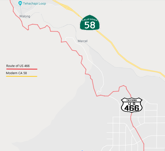


Bena Road starts at the CA 58 junction with Bealville Road. US 466 would have followed Bena Road westward as it crosses under the grade of CA 58.


Interestingly Bear Mountain which is 6,916 feet above sea level can be seen from Bena Road at the CA 58 underpass.

Bena Road is now maintained as Kern County Road 226H.

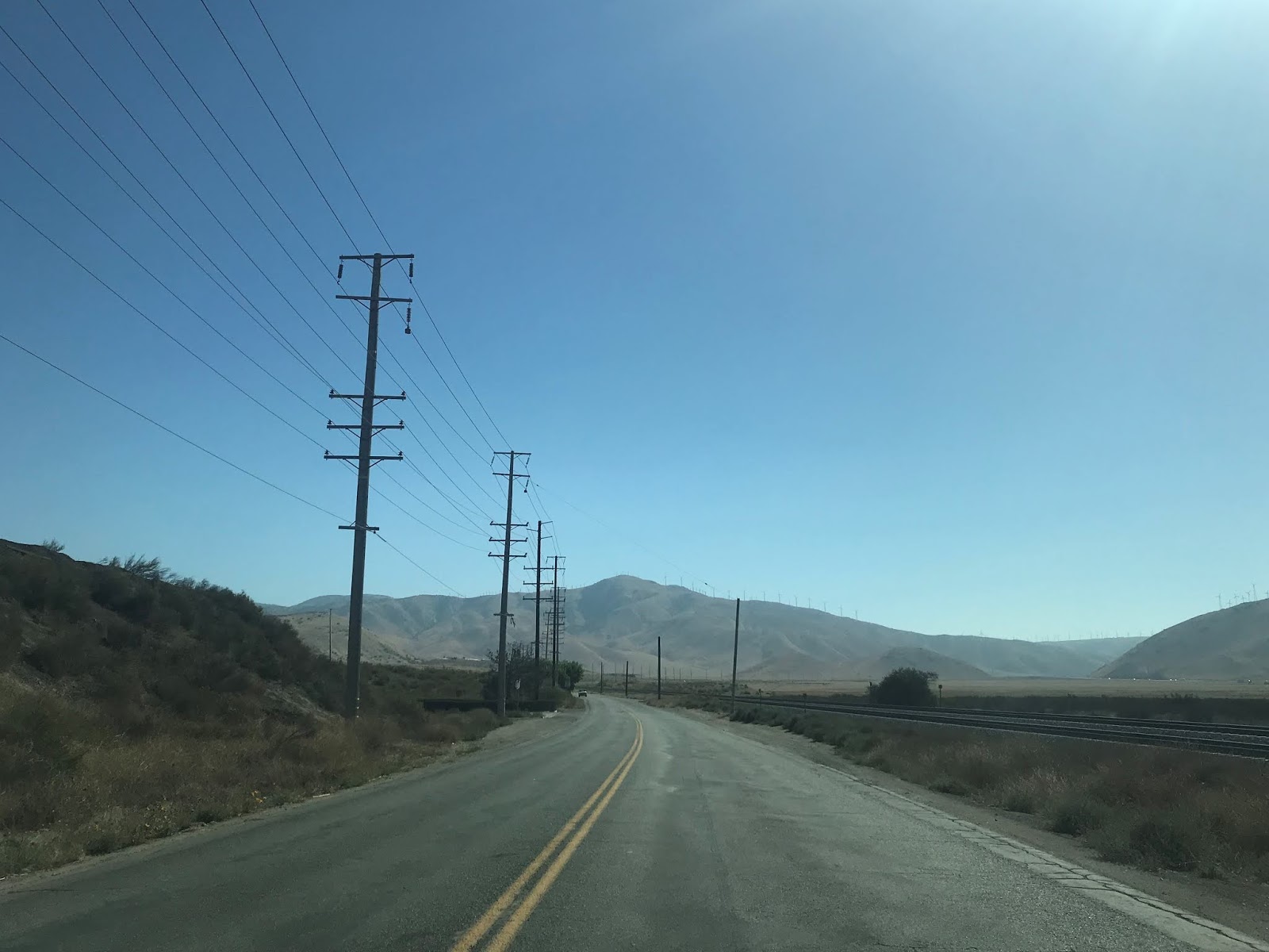
Bena Road and US 466 followed Caliente Creek into San Joaquin Valley. The canyon grades are really quite good and very well maintained. I'm to understand that the wooden guard rails might be original California Division of Highway construction back to the US 466 era.


Bena Road climbs a large bluff and splits away from Caliente Creek.


At Tower Line Road the designation of Bena Road changes to Edison Highway. US 466 continued west through the community of Edison on Edison Highway.


West of Edison the alignment of US 466 on Edison Highway met LRN 143 at Weedpatch Highway. Weedpatch Highway is now signed as CA 184.


At this at-grade railroad crossing US 466 on Edison Highway would have entered the City of Bakersfield.

US 466 made a turn towards downtown Bakersfield on Sumner Street.

This map below visually shows the alignment of US 466 on Bena Road, Edison Highway, and Sumner Street.

Originally US 466 would have met CA 178 on Sumner Street at Beale Avenue at an at-grade intersection. CA 178 would have multiplexed US 466 west to 24th Street, today Beale Avenue is on a fly-over grade.

At Union Avenue/Golden State Avenue US 466 met US 99 and US 399. US 399 had a northern terminus multiplexed on US 99 directly to the left on Union Avenue. US 466 would have split right on US 99 via Golden State Avenue, CA 178 would have followed to 24th Street until it was realigned in 1963.

US 466 and US 399 oddly never had alignment shifts through downtown Bakersfield. US 99 and CA 178 shifted course various times, this map below is a quick illustration showing them all in one photo.

US 99/466 multiplexed through Bakersfield on Golden State Avenue on what is now the routing of CA 204 to CA 99.


From the end of CA 204 the alignment of US 466 followed US 99 on what is now the CA 99/Golden State Freeway to Famoso. Much of the Golden State Freeway north to Fresno was built upon the original alignments of US 99. From Famoso US 466 cut west on what is now modern CA 46 which was covered in Part 1.
US 466 from Tehachapi west to Bakersfield wasn't upgraded to an expressway/freeway until it was renumbered to CA 58. To that end the US 466 became an extremely important corridor even from I-15/I-40 in Barstow and has seen continuing improvements, most recently with the Hinkley Bypass. The Kramer Junction bypass will be the last section of US 466 between Bakersfield and Barstow to be replaced, to that end I'll probably cover that particular project some time in 2019.
The entire alignment of US 466 as it was in Kern County can be viewed on this 1935 California Division of Highways Map.

Update 10/2/19: This past weekend I revisited Tehachapi and drove former US 466 from CA 58 east on Tehachapi Boulevard towards the Sand Canyon Road exit.




Comments