
A popular pastime within the roadgeeking hobby is county collecting. In a nutshell, you keep track of all the counties in the US - and now Canada and Mexico - that you have been in. It is one of those quirky little things that not only roadgeeks enjoy but also pretty much anyone that likes to travel. Mob-Rule.com is the home for most county collectors and it is an interactive site that allows you to track your counties and label them however you wish. You can label them by year visited, by if you have resided or spend the night there, how you visited them and even with whom. Others even have rules for the counties to count, they or their spouse has to actually be driving, must visit the county seat, must do some sort of activity or transaction within the county.
I started keeping track of my overall counties about 15 years ago. It was a lot easier to remember where and when you went there when you were 26 then now at 41. County collecting can easily be a family affair. I keep track of the counties both of my son's - Colton (5) and Nash (2) - have been to. In Colton's case, he really enjoys it. We started to tell him about his new counties when he was close to three, and he's been excited about getting new ones ever since. In 2017, when we went to St. Louis on vacation, Colt told me his goal was to get 100 counties on the trip. Though we didn't, he would ask how many we got each day and what part of the state they were in. On a recent trip from Charlottesville, Virginia to Charlotte, North Carolina, he picked up another six counties and was upset that he couldn't get ten!
I can't say that we are the first to keep track of our children's counties. A good personal friend of mine - and also part of the hobby - Chris Allen - started to keep track of counties for his oldest daughter, Marla. He would then also do the same for their youngest son, Bruce. A number of other roadgeeks do this also.
However, the Allen's have done another great idea. They have been keeping track of counties that their family of four have done together. But this is where they take it to another level, the Allen's have blown up a photo of the US county map that is found on Mob-Rule, and after every trip that they collect, the family colors in the counties they have visited. The map then goes back in the picture frame and is hung proudly in their living room.
The Allen's were kind enough to share photos of the family updating their county map after their most recent cross-country adventure to New Mexico and Arizona!
This is a great way to get the whole family involved in a silly little hobby and can make those long road trips with kids a little more tolerable.
I started keeping track of my overall counties about 15 years ago. It was a lot easier to remember where and when you went there when you were 26 then now at 41. County collecting can easily be a family affair. I keep track of the counties both of my son's - Colton (5) and Nash (2) - have been to. In Colton's case, he really enjoys it. We started to tell him about his new counties when he was close to three, and he's been excited about getting new ones ever since. In 2017, when we went to St. Louis on vacation, Colt told me his goal was to get 100 counties on the trip. Though we didn't, he would ask how many we got each day and what part of the state they were in. On a recent trip from Charlottesville, Virginia to Charlotte, North Carolina, he picked up another six counties and was upset that he couldn't get ten!
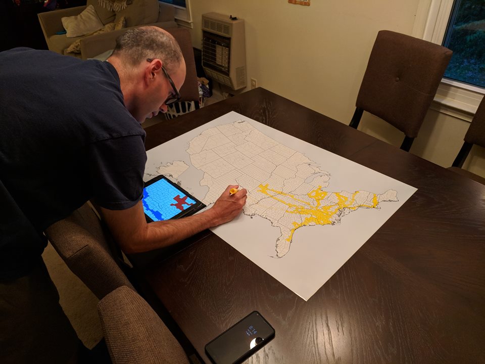 |
| Chris Allen updating the family county map after their recent cross-country roadtrip |
However, the Allen's have done another great idea. They have been keeping track of counties that their family of four have done together. But this is where they take it to another level, the Allen's have blown up a photo of the US county map that is found on Mob-Rule, and after every trip that they collect, the family colors in the counties they have visited. The map then goes back in the picture frame and is hung proudly in their living room.
 |
| The finished product! |
This is a great way to get the whole family involved in a silly little hobby and can make those long road trips with kids a little more tolerable.
Comments