This week on throwback Thursday I look back at Arizona State 88 otherwise known as the Apache Trail.

AZ 88 is one of the original 1927 Arizona State Highways. The current configuration of AZ 88 is about 46 miles long running from US 60 in Apache Junction northeast to AZ 188. The reputation of AZ 88 is among the most infamous in Arizona as it is one of the few remaining dirt state highways with approximately half the modern mileage unpaved. The entire unpaved portion of AZ 88 is east of Tortilla Flat along the Salt River in the remote Superstition Mountains to Roosevelt Dam.
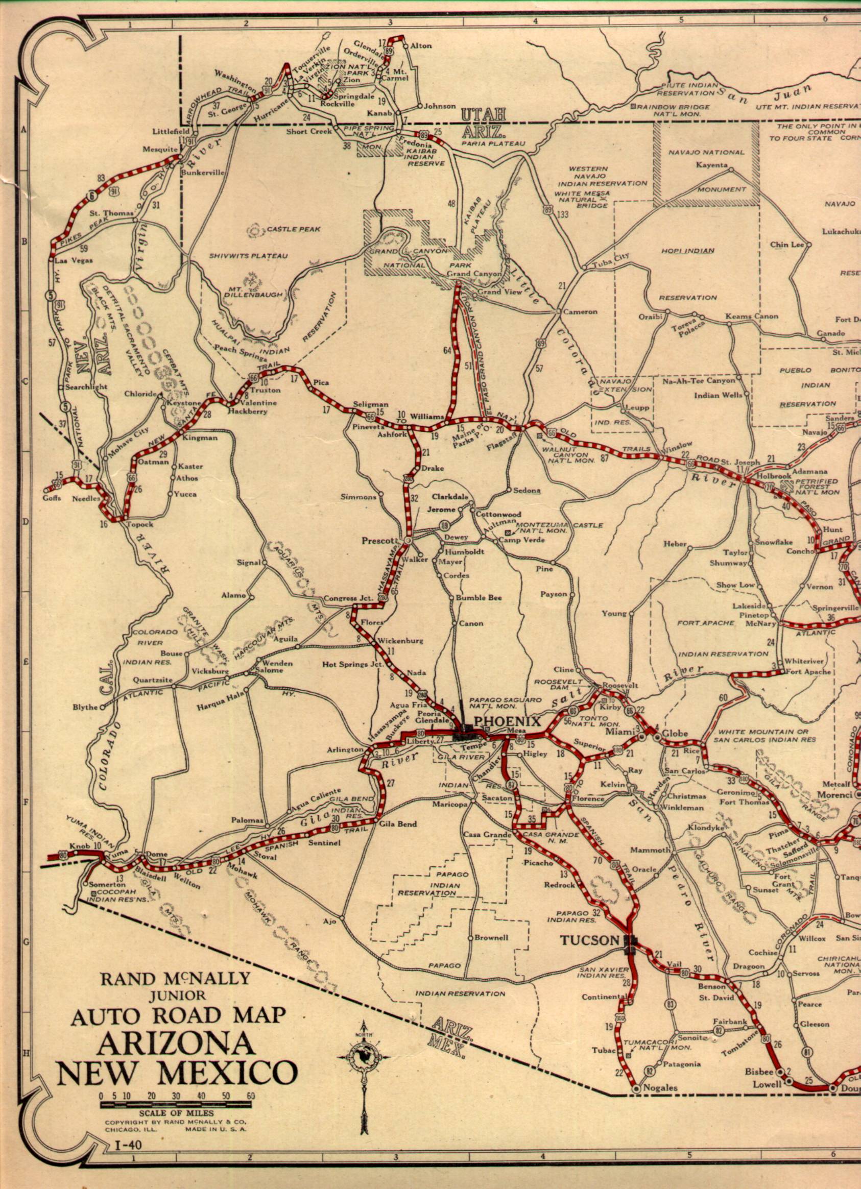
Originally in 1927 AZ 88 was substantially longer in length continuing east from Roosevelt Dam to the City of Globe. The eastern terminus of AZ 88 was cut back to Roosevelt Dam in 1999 when AZ 188 was extended southward to Globe. Originally AZ 88s western terminus was in Apache Junction at US 80 which eventually became a multiplex of US 60/70/80/89 before being reduced to US 60 by 1971. I'm not one hundred percent certain but I believe the western terminus of AZ 88 was shifted south on Idaho Avenue to the US 60 freeway when AZ 360 was renumbered in 1992. The original alignment of AZ 88 can be observed on the 1927 state highway map.
1927 Arizona State Highway Map
The history of AZ 88 is tied to the Salt River Project which was a reclamation project approved along the Salt River in 1903. The first reservoir to built along the Salt River Project was Roosevelt Dam which was under construction from 1903 to 1911. As part of the Salt River Project a Stage Route known as the Apache Trail was built from the Phoenix area to Roosevelt Dam. The Apache Trail was named as such due to it being built over a known trail that used to be utilized by the Apache Tribe to traverse the Salt River wilderness of the Superstition Range.
Roosevelt Dam was completed in 1911 and for a short period of time was the largest reservoir in the world. The second Salt River Project Reservoir was Canyon Lake which was impounded by Mormon Flat Dam upon completion west of Tortilla Flat in 1925. The third reservoir called Apache Lake was completed upon construction of Horse Mesa Dam along the Apache Trail in 1927 (the year state highways became signed in Arizona) east Tortilla Flat. The only Salt River Project reservoir not along the Apache Trail was Saguaro Lake which is just west of Canyon Lake.
Essentially continued use of the Salt River Project ensured that AZ 88/Apache Trail continued to be a state highway into modern time despite little improvements over the years. The paved section is fun as hell for a weekend drive for lunch at Tortilla Flat while the dirt segment is hazardous enough to an off-road driver interested but just gentle enough for a car (emphasis on barely). I have a lot of photos over the years from AZ 88 and it remains one of my favorite highways.
Starting out traveling east from Apache Junction there is a ghost town-turned-park called Goldfield. Goldfield was established in 1893 but was quickly abandoned by 1898 when the gold mines were shuttered. Goldfield's mined reopened in 1920 and the town was renamed "Youngberg." Youngberg only remained viable into the late 1920s before shuttering again. Youngberg was restored and renamed Goldfield which eventually opened as a park.


Directly east of Goldfield is Lost Dutchman State Park which is easily observed by the towering bluffs of the Superstition Range. Supposedly the Lost Dutchman's Mine was found some time possibly in the 1870s within vicinity of a rock formation of Weaver's Needle. I would find that claim highly unlikely given how far south Weaver's Needle is of the Salt River. In used to hike out to Weaver's Needle via the Peralta Trail, the area really is hostile and foreboding as any story you've heard.

Most of the paved section of AZ 88 east of Goldfield to Tortilla Flat is signed as 25 MPH by ADOT and is pretty beat up. The road is extremely twisty but comes out to some great overlooks of the Four Peaks to the north in the Mazatzal Range. I always found it odd that Four Peaks were displayed on the Arizona State License Plate rather than something more notable like the Grand Canyon or US Route 66.


The first lake encountered on AZ 88 is Canyon Lake which has a nice Tonto National Forest Overlook.


AZ 88 utilizes a couple of one-lane steel truss bridges over the waters of Canyon Lake.


Shortly east of Canyon Lake is the descent to Tortilla Flat.

There is a hell of a view of Canyon Lake looking back west.

Tortilla Flat is stage station built in 1904 to facilitate travel to Roosevelt Dam. Back in 2012 the owner's of Tortilla Flat were promoting the site as the smallest recognized community in Arizona. Much of Tortilla Flat's original structures burned in a fire and were rebuilt. I believe the school building is an original structure.


The dirt segment of AZ 88 begins a couple miles east of Tortilla Flat. I on occasion took my truck out to AZ 88 in the early 2000s when the dirt roadway was in really rough shape. The road is essentially one and a half lanes which runs along the rim of a canyon above the Salt River and Apache Lake. There is a one-lane bridge on the dirt segment which is a pretty shocking site to behold when you realize it maintained by ADOT. I last attempted the dirt segment of AZ 88 on a 2016 vacation but I found the heavy wash boarding to be more than I wanted to do in rental car and turned back.
As for Roosevelt Dam and the eastern terminus of AZ 88, it has a hell of an overlook of the dam in addition to Roosevelt Lake. Roosevelt Dam was expanded in the 1990s which covered much of the masonry structure with concrete. Originally AZ 188 was created in 1950s it used to cross Roosevelt Dam before it was moved to a new suspension bridge. When the waters of Roosevelt Lake are low the old masonry section of the dam can still be seen.


AZ 88 is one of the original 1927 Arizona State Highways. The current configuration of AZ 88 is about 46 miles long running from US 60 in Apache Junction northeast to AZ 188. The reputation of AZ 88 is among the most infamous in Arizona as it is one of the few remaining dirt state highways with approximately half the modern mileage unpaved. The entire unpaved portion of AZ 88 is east of Tortilla Flat along the Salt River in the remote Superstition Mountains to Roosevelt Dam.
Originally in 1927 AZ 88 was substantially longer in length continuing east from Roosevelt Dam to the City of Globe. The eastern terminus of AZ 88 was cut back to Roosevelt Dam in 1999 when AZ 188 was extended southward to Globe. Originally AZ 88s western terminus was in Apache Junction at US 80 which eventually became a multiplex of US 60/70/80/89 before being reduced to US 60 by 1971. I'm not one hundred percent certain but I believe the western terminus of AZ 88 was shifted south on Idaho Avenue to the US 60 freeway when AZ 360 was renumbered in 1992. The original alignment of AZ 88 can be observed on the 1927 state highway map.
1927 Arizona State Highway Map
The history of AZ 88 is tied to the Salt River Project which was a reclamation project approved along the Salt River in 1903. The first reservoir to built along the Salt River Project was Roosevelt Dam which was under construction from 1903 to 1911. As part of the Salt River Project a Stage Route known as the Apache Trail was built from the Phoenix area to Roosevelt Dam. The Apache Trail was named as such due to it being built over a known trail that used to be utilized by the Apache Tribe to traverse the Salt River wilderness of the Superstition Range.
Roosevelt Dam was completed in 1911 and for a short period of time was the largest reservoir in the world. The second Salt River Project Reservoir was Canyon Lake which was impounded by Mormon Flat Dam upon completion west of Tortilla Flat in 1925. The third reservoir called Apache Lake was completed upon construction of Horse Mesa Dam along the Apache Trail in 1927 (the year state highways became signed in Arizona) east Tortilla Flat. The only Salt River Project reservoir not along the Apache Trail was Saguaro Lake which is just west of Canyon Lake.
Essentially continued use of the Salt River Project ensured that AZ 88/Apache Trail continued to be a state highway into modern time despite little improvements over the years. The paved section is fun as hell for a weekend drive for lunch at Tortilla Flat while the dirt segment is hazardous enough to an off-road driver interested but just gentle enough for a car (emphasis on barely). I have a lot of photos over the years from AZ 88 and it remains one of my favorite highways.
Starting out traveling east from Apache Junction there is a ghost town-turned-park called Goldfield. Goldfield was established in 1893 but was quickly abandoned by 1898 when the gold mines were shuttered. Goldfield's mined reopened in 1920 and the town was renamed "Youngberg." Youngberg only remained viable into the late 1920s before shuttering again. Youngberg was restored and renamed Goldfield which eventually opened as a park.


Directly east of Goldfield is Lost Dutchman State Park which is easily observed by the towering bluffs of the Superstition Range. Supposedly the Lost Dutchman's Mine was found some time possibly in the 1870s within vicinity of a rock formation of Weaver's Needle. I would find that claim highly unlikely given how far south Weaver's Needle is of the Salt River. In used to hike out to Weaver's Needle via the Peralta Trail, the area really is hostile and foreboding as any story you've heard.

Most of the paved section of AZ 88 east of Goldfield to Tortilla Flat is signed as 25 MPH by ADOT and is pretty beat up. The road is extremely twisty but comes out to some great overlooks of the Four Peaks to the north in the Mazatzal Range. I always found it odd that Four Peaks were displayed on the Arizona State License Plate rather than something more notable like the Grand Canyon or US Route 66.


The first lake encountered on AZ 88 is Canyon Lake which has a nice Tonto National Forest Overlook.


AZ 88 utilizes a couple of one-lane steel truss bridges over the waters of Canyon Lake.


Shortly east of Canyon Lake is the descent to Tortilla Flat.

There is a hell of a view of Canyon Lake looking back west.

Tortilla Flat is stage station built in 1904 to facilitate travel to Roosevelt Dam. Back in 2012 the owner's of Tortilla Flat were promoting the site as the smallest recognized community in Arizona. Much of Tortilla Flat's original structures burned in a fire and were rebuilt. I believe the school building is an original structure.


The dirt segment of AZ 88 begins a couple miles east of Tortilla Flat. I on occasion took my truck out to AZ 88 in the early 2000s when the dirt roadway was in really rough shape. The road is essentially one and a half lanes which runs along the rim of a canyon above the Salt River and Apache Lake. There is a one-lane bridge on the dirt segment which is a pretty shocking site to behold when you realize it maintained by ADOT. I last attempted the dirt segment of AZ 88 on a 2016 vacation but I found the heavy wash boarding to be more than I wanted to do in rental car and turned back.
As for Roosevelt Dam and the eastern terminus of AZ 88, it has a hell of an overlook of the dam in addition to Roosevelt Lake. Roosevelt Dam was expanded in the 1990s which covered much of the masonry structure with concrete. Originally AZ 188 was created in 1950s it used to cross Roosevelt Dam before it was moved to a new suspension bridge. When the waters of Roosevelt Lake are low the old masonry section of the dam can still be seen.


Comments