Sometimes when you look through a box of maps for the first time in five years, you come across something you may have easily over looked. Such was the case when I found a 2004 (so rather recent) map of Raleigh. This map was made by the Dolph Map Company for WakeMed. In the Northwestern corner of Wake County, there were two items to the map showing roads that are still not in existence 13 years later.
The road is the Northern Durham Parkway - this is a proposed 19 mile highway from US 501 north of Durham to the Raleigh-Durham International Airport. The first proposals for this highway date back to 1967 when Eno Drive-Gorman Road was listed on the Durham Area Thoroughfare Plan. (1) Other proposals called the highway the Northwest and Northeast Durham Loop. (2) The route would serve as a northern and eastern bypass of Durham almost serving as a near loop. The route was fought vigorously for three decades by the Eno River Association citing concerns for the the Eno River, nearby neighborhoods, and Eno River State Park.
In the late 1990s, Durham County Commissioners and the Durham City Council put together a compromise plan that eliminated the proposed loop west of US 501. This plan would be called the Northern Durham Parkway. (2) In December of 2002, it was agreed to go forward with the compromise plan - the Northern Durham Parkway. (3) The route would now run from Interstate 540 at Exit 2 (Aviation Parkway) north to Interstate 85 and north to Old Oxford Road before turning to the Northwest to end at US 501.
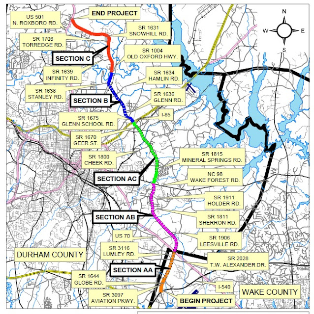 |
| The proposed route of the Northern Durham Parkway/NC 472 - Source: NCDOT |
There is at least one example of planning maps that show the full route of the Northern Durham Parkway along the Eno River. At one of NCDOT's transportation management centers, the route of the proposed Northern Durham Parkway is shown.
 |
| The Northern Durham Parkway would have served as a Northern Arc of Interstate 85 in Northern Durham County (Ben Thurkill) |
In 2014, NCDOT
completed a feasibility study that estimated the cost of completing the highway at between $254 and $361 million. The price range is dependent on how much of the highway would be built as a freeway vs. how much built as a boulevard. Section AA which is the Aviation Parkway extension to US 70/Glenwood Avenue would be built as a freeway in all scenarios. One proposal has the highway being a freeway for sections AA, AB and AC - all the way to Interstate 85. NCDOT has reserved
NC 472 for this route. There is no current discussion proposing, that if the Northern Durham Parkway is built as a freeway from Interstate 540 to Interstate 85, it would be designated as a new Interstate.
Currently, two small sections of the highway are open. Aviation Parkway from I-540 to Globe Road and a small section of highway called the Northern Durham Parkway off Sherron Road.
In addition, there is a small section of preserved right of way in the Copley Farm area just north of Mineral Springs Road (Section AC). The preserved width of the right-of-way is 130' to carry a four lane divided highway. (4)
Additional clues to the Parkway's routing come into play with the 2004 Raleigh map find. The map, as shown below, shows an extension of Aviation Boulevard (the Airport Blvd. notation is in error) beyond its current end at a 'T' intersection with Globe Road to just beyond T.W. Alexander Blvd. It also shows that the intersection with Globe Road would become a partial-cloverleaf interchange. This is confirmed in the 2014 NCDOT Feasibility Study.
 |
| Aviation (not Airport) Boulevard is shown going north beyond Globe Road towards T.W. Alexander. This would be great except in 2004 Aviation ended and still ends today at Globe Road. (Dolph Map Co., 2004) |
Further, this same map also includes an item that I am not sure is on NCDOT's books anymore. It is a direct connector from Interstate 540 to the Northern Durham Parkway. This connector would begin at Interstate 540 between Exits 4 and 7 (Glenwood/US 70 and Leesville Road). In fact, if you are traveling on I-540 East and look closely you will see what is left of the grading of off and on ramps for the exit to the connector. They are now overgrown with pine trees, but it's there.
You can somewhat see the grading for the ramps to the Northern Durham Connector Interchange. What is more obvious is the reserved right of way to the north of Interstate 540. It appears that the interchange was to be a trumpet interchange with the highway not continuing southwards towards Glenwood Avenue. However, the 2004 map shows a different type of highway and interchange altogether.
 |
| Another highway that isn't there - the 540 connector to the Northern Durham Parkway (Dolph Map Co., 2004) |
This shows a full fledged freeway to freeway cloverleaf interchange. According to Brian LeBlanc, this was never to be a full freeway but a boulevard like connector. Further supporting that this is just a map error is that a full freeway would be difficult to shoehorn south of I-540 through the number of commercial and light industrial businesses that occupy this corridor. These businesses can clearly be seen in the Google Satellite image earlier in the article. I do not know if this connector is still a possibility; the 2014 NCDOT study does not include it.
As for the future of this highway, it is pretty much unknown. It was listed as an unfunded project as late as
June 2015. Additionally, the current State Transportation Improvement Program does not have the project listed. However, the region's growth will most likely cause the need for this highway to surface in the near future. When that may happen, it is unknown. But thanks to a trip to the attic and a look through a box of old maps - a little more detail about this planned highway is now known
If you have any information about the Northern Durham Parkway, shoot me a note or leave a comment below.
Sources & Links:


Comments
I am planning to buy a house which is near to this Expansion Route and concerned about the future effect on the house.
https://durhamnc.gov/AgendaCenter/ViewFile/Item/2029?fileID=7281