The tale of CA 270 being adopted into the state highway system along Bodie Road is a fairly modern one. According to CAhighways a 13 mile segment of Bodie Road from US 395 eastward was adopted to the ghost town of Bodie located in Bodie State Historic Park in 1970. All of Bodie Road shows as county maintained to the Nevada State Line at NV 3C on the 1970 Map with the planned state highway alignment shown on the 1975 State Highway Map:
1970 State Highway Map
1975 State Highway Map
Between 1979 and 1981 the first 10 miles of a planned 13 mile CA 270 appears to have been completed. My understanding is the final three miles was kept as dirt by the request of Bodie State Historic Park to keep the ambiance of the ghost town. CAhighways states that District 9 recommended the deletion of the dirt segment to Bodie from the state highway system, I would assume that was actually done given the "End" shield/placard is located where the asphalt ends.
1979 State Highway Map
1981 State Highway Map
As for Bodie itself it was established as a small mining camp in 1859 after the discovery of gold in the Bodie Hills which is a sub-range of the Sierras. Large ore deposits were found in 1876 and 1878 which led to a population swell to at least 5,000 people in Bodie by 1879. The Bodie and Benton Railroad was a 32 mile line built from Mono Mills north to Bodie to transport lumber. The line followed the eastern shore of Mono Lake, crossed what is now CA 167, and ascended what is now Cottonwood Canyon Road to Bodie. More details about the Bodie and Benton Railroad can be found on abandonedrails.com.
http://www.abandonedrails.com/Bodie_and_Benton_Railroad
The population decline in Bodie started in the 1880s and progressed through the early 20th century. By 1940 the Census showed only 40 residents left in the town of Bodie. The Bodie and Benton Railroad was dismantled in 1918 when the population of Bodie might have still exceeded just slightly over 100. Post Office Service stopped in Bodie in 1942 and there was only three people recorded living in the town by 1943. The remains of Bodie was turned into a State Park in 1962 when a little under 200 of the claimed original 2,000 buildings were left standings.
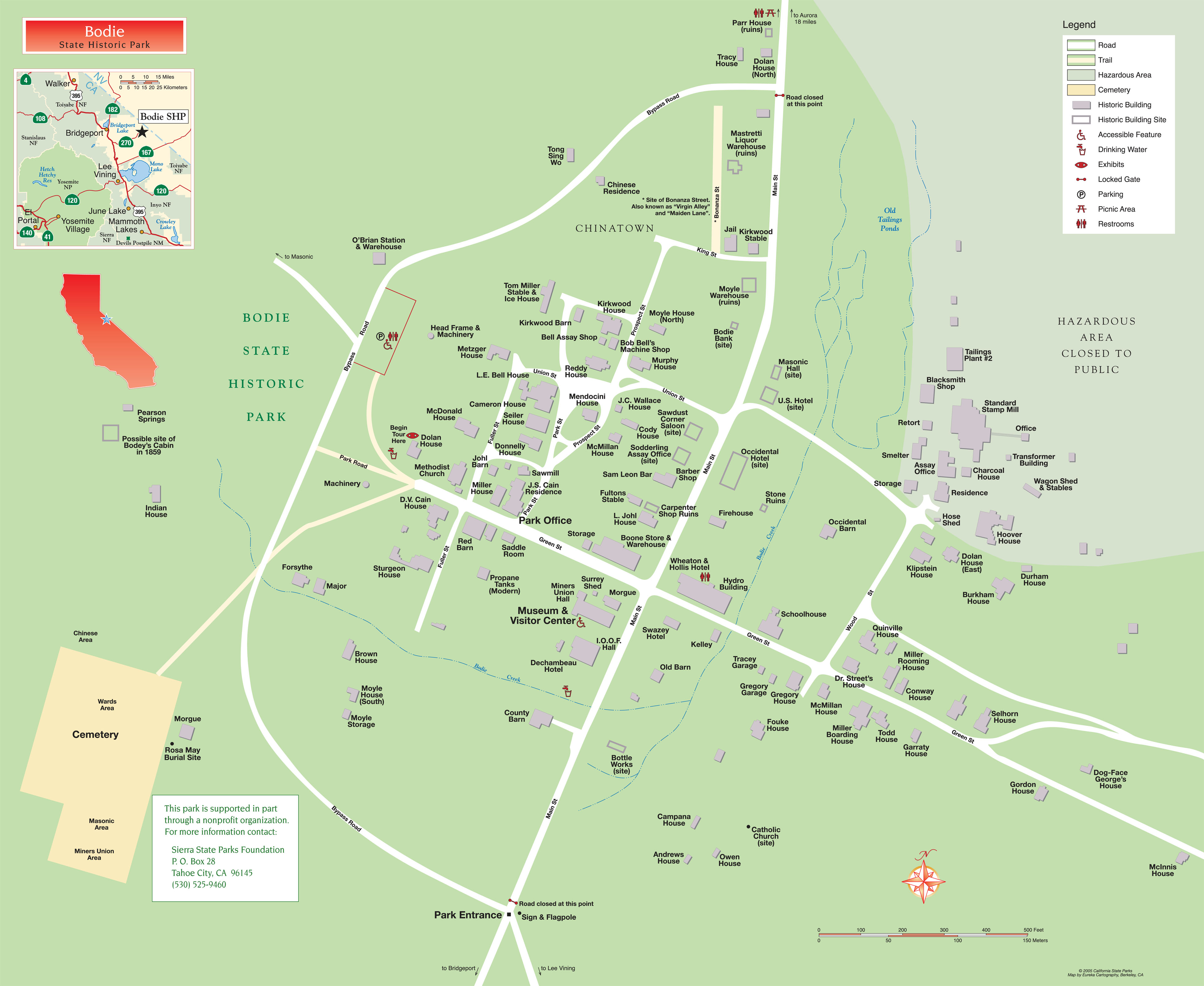
As for as road transportation in Bodie, the best map of the town I could find is located on the link below.
Map of the town of Bodie
I'm almost certain that the bypass road of Bodie which accesses the State Park parking lot is a modern construction given the higher grade gravel that is present on it. To reach Aurora in Nevada it would seem that you would need to enter Bodie via Main Street and follow it out of town where Bodie Road would resume. Bodie Road continues another 9-10 miles to NV 3C which is about another 3-4 miles away from the Aurora ghost town which was once thought to be in California and was even the Mono County seat at one point. NV 3C continues north to NV 208 south of Yerington which would have been NV 3 prior to the 1976 Nevada State Highway renumbering. NV 3C isn't part of the Nevada State Highway system today and never appears to have been maintained beyond the county level. According to what I was told last year you'll need a high clearance vehicle to get through NV 3C to NV 208 given that that a bridge failed just over the Nevada State Line.
Bodie-Masonic Road traverses north out of Bodie to the ghost town called Masonic. From Masonic CA 182 can be reached via Masonic Road by traveling southwest. There is a couple additional mining ghost town sites in the general area around the Bodie Hills, but nothing that appears to have been much more than a collection of shacks.
As for CA 270 it is well signed from US 395 north.
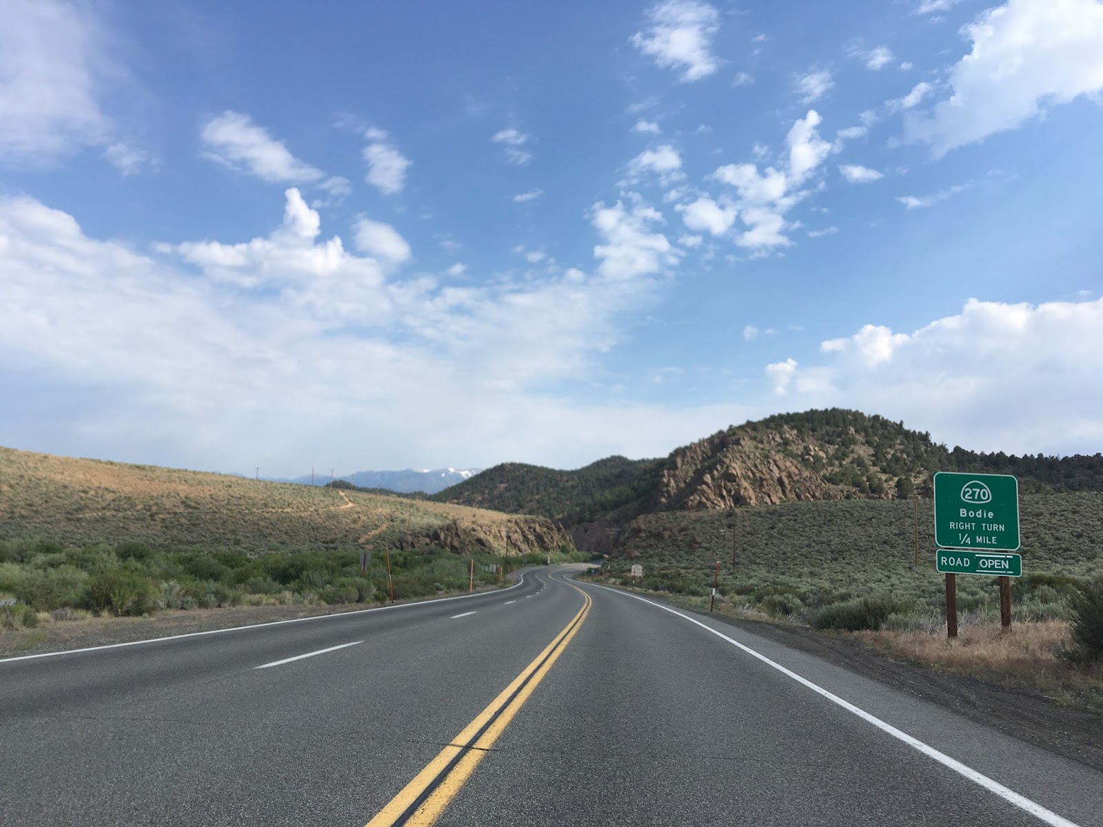
Turning east on to 270 there is no reassurance shield. All that is present is a sign stating the next 10 miles have curves along with signage for Bodie State Historic Park


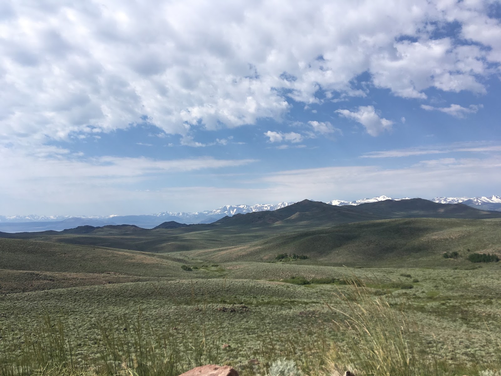
The first couple miles of 270 are pretty tame traversing a valley with grazing sheep herds.


CA 270 begins to climbe 8% grades up to the eastern terminus begin with the elevation climbing over 8,000 feet above sea level.


Approaching the eastern terminus of CA 270 you are greeted by "rough road" and "pavement ends" signage.


At the eastern terminus of CA 270 there is a new sign for Bodie and an
"End" shield/placard combo assembly. The CA 270 shield for westbound assembly was stolen since 2016 but
the "west" placard is still present.


A quick look back west into the High Sierras.

The final three miles of Bodie Road to the town is badly wash boarded. Bodie Road is graded but there are sizable rocks that probably are capable of cutting a tire along with some deep ruts.

On a clear day Mono Lake can be seen to the south of Bodie Road.
The actual park gate is located one mile from Bodie and even has a cattle guard.

There is a small descent into Bodie which is at 8,379 feet above sea level.

Bodie State Historic Park even has a grading machine which often is seen patching up Bodie Road east of the terminus of CA 270.

There is one additional gate with another cattle guard. Obviously deterring vandals seems to be a huge concern for Bodie State Historical Park.

Did I mention the dirt segment of Bodie Road is heavily wash boarded?

Approaching Bodie the grade of the Bodie and Benton Railroad can be observed directly ahead of the gate to the right.

Access to Main Street is blocked to vehicular traffic. My understanding is that traffic heading to NV 3C doesn't have to pay the State Park entry fee.

Main Street appears to still be maintained to a high enough standard for a normal vehicle to traverse.


There is an old gas station at the junction of Main Street and Green Street.


Leaving Bodie eastward on Main the road narrows significantly but the grade remains in place.


Looking back west on Main Street towards Bodie at the junction of the bypass road,

Looking east on Bodie Road which continues to the Nevada State Line and NV 3C.

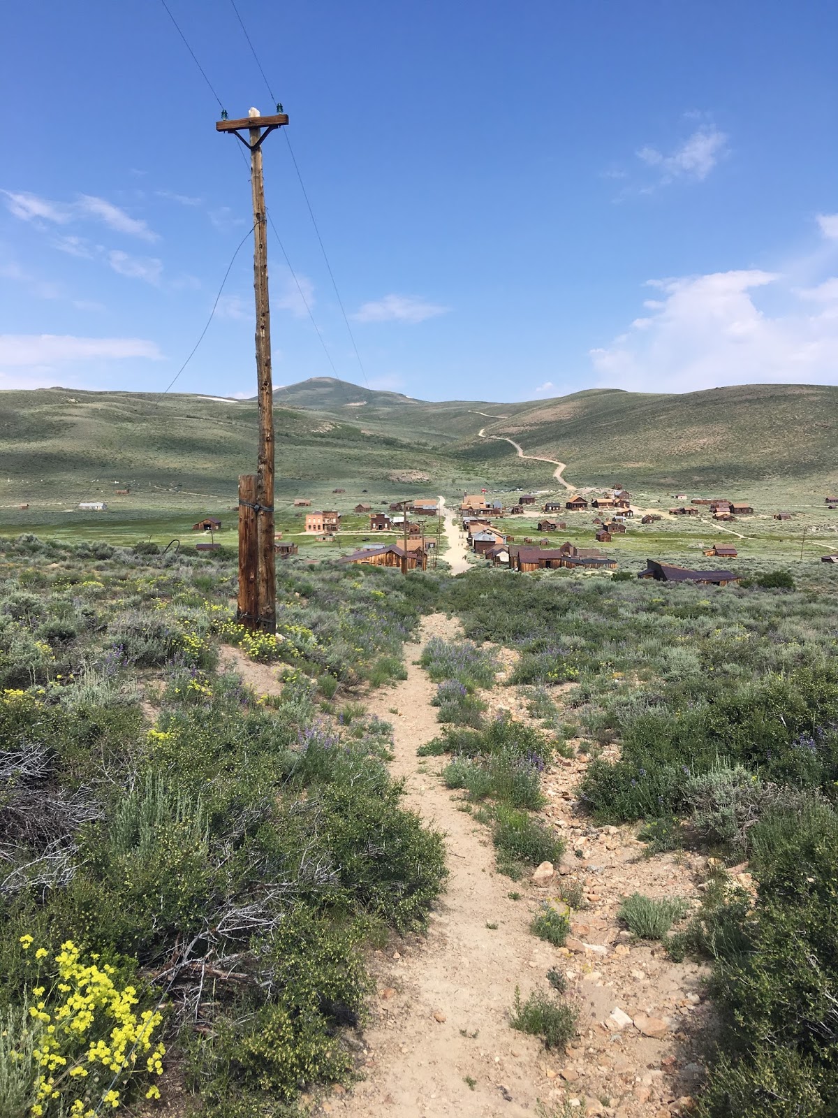
Something I thought was cool was this view from the top of Green Street
looking north towards Bodie and Bodie-Masonic Road in the distance. I'm
fairly certain that Bodie-Masonic Road once ran to Green Street before the
State Park facility and bypass road were built.

In regards to transportation in and around Bodie that's really all there is to cover. The town has an endless swath of abandoned structures and infrastructure that is worth exploring. The mining history of Bodie is a fascinating topic but I'll probably devote an entire blog to that. The only other transportation piece I wanted to share from Bodie was this vintage Firestone Tire ad from Main Street in Bodie.

Comments