After completing CA 167 I had my choice of several routes over get back west to San Joaquin Valley over the Sierras. Given the mountainous nature of several of the roads I drove over the weekend County Route J41 up Nine Mile Canyon leading to Sherman was more than I wanted and CA 58 over Tehachapi Pass was a little passe given it is a major highway. That being the case I settled on CA 178 over Walker Pass which exits into San Joanquin Valley via the Kern River Canyon.

Much of CA 178 near what is now Lake Isabella was heavy realigned as the reservoir was being constructed along the Kern River. The towns of Isabella and Kernville were relocated above the waters of what would become Lake Isabella. Socalregion.com did an extensive write-up on the original alignment of CA 178 which is now located at the bottom of Lake Isabella.
Socalregion.com on CA 178
With that said, the original alignment of CA CA 178 from Walker Pass west to Bakersfield can be viewed on the 1935 California Division of Highways Map of Kern County along with the 1938 State Highway Map. Interestingly the 1938 has CA 178 on Legislative Route 142 (future CA 155) but it is a map error, the city insert has the alignment shown correct.
1935 Kern County Highway Map
1938 State Highway Map
The realignment of CA 178 for the Lake Isabella project can be seen by comparing the 1952 State Highway Map and 1953 State Highway Map.
1952 State Highway Map
1953 State Highway Map
The modern expressway from Lake Isabella west to Kern River Canyon was completed sometime between 1970 and 1975 which can be seen comparing the maps from those two years. There was a proposed realignment of CA 178 out of the Kern River Canyon but it was never constructed.
1970 State Highway Map
1975 State Highway Map
Walker Pass lies at 5,520 feet above sea level and was first traversed by Europeans who learned of it from the Native American tribes in 1834. The first wagon train to use Walker Pass was in 1843 and it was called Walker Pass by 1845. Walker Pass was indirectly the reason why Death Valley was accidentally discovered when the Lost 49ers attempted to find a short cut through the Great Basin and Mojave Deserts. Apparently emigrants were too afraid to try Donner Pass early in the fall season after the fate of the Donner Party in 1846. Interestingly the Lost 49er party actually made it out of Death Valley but still missed Walker Pass which is detailed by the National Park Service.
NPS.gov/Death Valley National Park on the Lost 49ers
Pulling off of the CA 14/CA 178 multiplex onto CA 178 westbound there was no reassurance shields. There is a large guide sign showing Bakersfield 87 miles to the west.

CA 14 used to part of US Route 6 before the 1964 State Highway renumbering. At junction of what was US 6/CA178 there is a historic marker for the ghost town known as Fremont Junction.


The climb west on CA 178 isn't particularly steep but quickly rises over 3,000 feet in elevation. The speed limit out in the Mojave is signed at 60 MPH.

As CA 178 crosses 4,000 feet above elevation it enters a small Joshua Tree forest.


The plant life begins to change at Walker Pass. There used to be a placard present but it disappeared recently but the historic marker still remains.


Walker Pass is very gentle and very wide. A lot of truckers use CA 178 over Walker Pass as an alternate to CA 58. Walker Pass rarely has chain controls in the winter is a really fun route compared to Tehachapi Pass to the south.

The Kern River Valley is very apparent descending Walker Pass. The curve ahead isn't as daunting as the 20 MPH advisory speed would suggest.

Surprisingly there is no overlook at Walker Pass. You can make one with the generously wide shoulders on CA 178.

There are double-side CA 178 reassurance shields at the bottom of Walker Pass.

The terrain of CA 178 levels and follows North Fork Kern River towards Lake Isabella. There are some really nice vista views from the shoulder and on from CA 178.


Oddly there is a guide sign and another reassurance shield east of Onyx floating pretty in the middle of nowhere.

There is a very old store in Onyx which apparently has been in operation since 1851.


The speed limit on CA 178 drops in Weldon which I suspect is due to the school located near the highway.

Approaching South Lake traffic on CA 178 picks up considerably as it approaches Lake Isabella. There is another guide sign immediately east of South Lake.


Approaching Mountain Mesa CA 178 begins to climb the bluffs south of Lake Isabella.


The water level in 2017 was actually pretty high compared to what it normally is in Lake Isabella. CA 178 would apparently have crossed left-to-right ahead in the photo below at water line. There was a distance forest fire high in the Sierras ahead which can be seen in the photo.

I kind of like the monochrome version of the same photo better.

Modern CA 178 rides the south shore of Lake Isabella.

At the Old Isabella Road boat ramp there is a historical marker for the original town site of Isabella. There is a nice view of Lake Isabella to the west of the historical marker.


Entering the community of Lake Isabella modern CA 178 splits off onto the modern expressway whereas the former alignment would have have been on Lake Isabella Blvd on the left.

CA 178 junctions CA 155 on the expressway bypass of Lake Isabella.

Down river from Isabella Dam most of the CA 178 follows the north bank of the Kern River whereas the original alignment is on the south bank on Kern Canyon Road.


The modern CA 178 expressway crosses the Kern River and meets Kern Canyon Road. CA 178 continues west to Bakersfield on Kern Canyon Road.

For some reason eastbound CA 178 has two-lanes substantially longer than westbound.

Kern Canyon Road is somewhat infamous locally in the Bakerfield area. The road follows close to the Kern River and is heavily patrolled. Had CA 178 been routed as an expressway to Bakerfield it would have been built high above Kern River Canyon. Kern River Canyon is 1,500-2,000 feet deep and is often mistaken for the Kern Fault far to the north in the High Sierras.


Kern Canyon Road is narrow but it is still fairly east to maintain the 55 MPH speed limit.


There are some decent draw distances on Kern Canyon Road for photos.
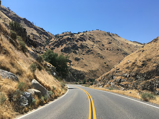

CA 178 drops to 1,000 feet above sea level approaching the mouth of Kern River Canyon.

Approaching the mouth of Kern River Canyon there is a small power station on the Kern River.


Kern River Canyon ends pretty abruptly at the edge of the city limits for Bakerfield. Bakersfield PD, Kern County Sheriff, and CHP love to stage vehicles at the mouth of Kern River Canyon.


There are some great photo opportunities at the mouth of Kern River Canyon.


There is a fatality counter eastbound entering Kern River Canyon.

CA 178 continues west on Kern Canyon Road to CA 178. Modern CA 178 continues westbound towards downtown Bakerfield on a freeway but would have originally turned on Kern Canyon Road which is now the northern extent of CA 184.


Much of CA 178 near what is now Lake Isabella was heavy realigned as the reservoir was being constructed along the Kern River. The towns of Isabella and Kernville were relocated above the waters of what would become Lake Isabella. Socalregion.com did an extensive write-up on the original alignment of CA 178 which is now located at the bottom of Lake Isabella.
Socalregion.com on CA 178
With that said, the original alignment of CA CA 178 from Walker Pass west to Bakersfield can be viewed on the 1935 California Division of Highways Map of Kern County along with the 1938 State Highway Map. Interestingly the 1938 has CA 178 on Legislative Route 142 (future CA 155) but it is a map error, the city insert has the alignment shown correct.
1935 Kern County Highway Map
1938 State Highway Map
The realignment of CA 178 for the Lake Isabella project can be seen by comparing the 1952 State Highway Map and 1953 State Highway Map.
1952 State Highway Map
1953 State Highway Map
The modern expressway from Lake Isabella west to Kern River Canyon was completed sometime between 1970 and 1975 which can be seen comparing the maps from those two years. There was a proposed realignment of CA 178 out of the Kern River Canyon but it was never constructed.
1970 State Highway Map
1975 State Highway Map
Walker Pass lies at 5,520 feet above sea level and was first traversed by Europeans who learned of it from the Native American tribes in 1834. The first wagon train to use Walker Pass was in 1843 and it was called Walker Pass by 1845. Walker Pass was indirectly the reason why Death Valley was accidentally discovered when the Lost 49ers attempted to find a short cut through the Great Basin and Mojave Deserts. Apparently emigrants were too afraid to try Donner Pass early in the fall season after the fate of the Donner Party in 1846. Interestingly the Lost 49er party actually made it out of Death Valley but still missed Walker Pass which is detailed by the National Park Service.
NPS.gov/Death Valley National Park on the Lost 49ers
Pulling off of the CA 14/CA 178 multiplex onto CA 178 westbound there was no reassurance shields. There is a large guide sign showing Bakersfield 87 miles to the west.

CA 14 used to part of US Route 6 before the 1964 State Highway renumbering. At junction of what was US 6/CA178 there is a historic marker for the ghost town known as Fremont Junction.


The climb west on CA 178 isn't particularly steep but quickly rises over 3,000 feet in elevation. The speed limit out in the Mojave is signed at 60 MPH.

As CA 178 crosses 4,000 feet above elevation it enters a small Joshua Tree forest.


The plant life begins to change at Walker Pass. There used to be a placard present but it disappeared recently but the historic marker still remains.


Walker Pass is very gentle and very wide. A lot of truckers use CA 178 over Walker Pass as an alternate to CA 58. Walker Pass rarely has chain controls in the winter is a really fun route compared to Tehachapi Pass to the south.

The Kern River Valley is very apparent descending Walker Pass. The curve ahead isn't as daunting as the 20 MPH advisory speed would suggest.

Surprisingly there is no overlook at Walker Pass. You can make one with the generously wide shoulders on CA 178.

There are double-side CA 178 reassurance shields at the bottom of Walker Pass.

The terrain of CA 178 levels and follows North Fork Kern River towards Lake Isabella. There are some really nice vista views from the shoulder and on from CA 178.


Oddly there is a guide sign and another reassurance shield east of Onyx floating pretty in the middle of nowhere.

There is a very old store in Onyx which apparently has been in operation since 1851.


The speed limit on CA 178 drops in Weldon which I suspect is due to the school located near the highway.

Approaching South Lake traffic on CA 178 picks up considerably as it approaches Lake Isabella. There is another guide sign immediately east of South Lake.


Approaching Mountain Mesa CA 178 begins to climb the bluffs south of Lake Isabella.


The water level in 2017 was actually pretty high compared to what it normally is in Lake Isabella. CA 178 would apparently have crossed left-to-right ahead in the photo below at water line. There was a distance forest fire high in the Sierras ahead which can be seen in the photo.

I kind of like the monochrome version of the same photo better.

Modern CA 178 rides the south shore of Lake Isabella.

At the Old Isabella Road boat ramp there is a historical marker for the original town site of Isabella. There is a nice view of Lake Isabella to the west of the historical marker.


Entering the community of Lake Isabella modern CA 178 splits off onto the modern expressway whereas the former alignment would have have been on Lake Isabella Blvd on the left.

CA 178 junctions CA 155 on the expressway bypass of Lake Isabella.

Down river from Isabella Dam most of the CA 178 follows the north bank of the Kern River whereas the original alignment is on the south bank on Kern Canyon Road.


The modern CA 178 expressway crosses the Kern River and meets Kern Canyon Road. CA 178 continues west to Bakersfield on Kern Canyon Road.

For some reason eastbound CA 178 has two-lanes substantially longer than westbound.

Kern Canyon Road is somewhat infamous locally in the Bakerfield area. The road follows close to the Kern River and is heavily patrolled. Had CA 178 been routed as an expressway to Bakerfield it would have been built high above Kern River Canyon. Kern River Canyon is 1,500-2,000 feet deep and is often mistaken for the Kern Fault far to the north in the High Sierras.


Kern Canyon Road is narrow but it is still fairly east to maintain the 55 MPH speed limit.


There are some decent draw distances on Kern Canyon Road for photos.


CA 178 drops to 1,000 feet above sea level approaching the mouth of Kern River Canyon.

Approaching the mouth of Kern River Canyon there is a small power station on the Kern River.


Kern River Canyon ends pretty abruptly at the edge of the city limits for Bakerfield. Bakersfield PD, Kern County Sheriff, and CHP love to stage vehicles at the mouth of Kern River Canyon.


There are some great photo opportunities at the mouth of Kern River Canyon.


There is a fatality counter eastbound entering Kern River Canyon.

CA 178 continues west on Kern Canyon Road to CA 178. Modern CA 178 continues westbound towards downtown Bakerfield on a freeway but would have originally turned on Kern Canyon Road which is now the northern extent of CA 184.


Comments