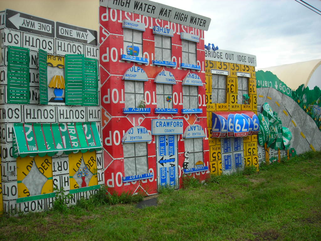
Meadville's PennDOT Road Sign Scultpture Garden

The PennDOT Road Sign Scultpture Garden in Meadville, Pennsylvania is a joint public art project between PennDOT and Allegheny College that began in 2002 to give a distinct look to Meadville's gateway from the west. Using recycled signs and tires, it is truly one of a kind. The sign garden is located at a Meadville PennDOT residency at US 6, US 19 and US 322's junction with PA 102, east of Interstate 79 and west of downtown Meadville. I've had a few occasions to check out the sign sculpture garden myself and I fully endorse recycling signs in this manner. It's a nice little stop to stretch your legs. I took the following pictures in September 2007.

One of the first parts of the project, and what you'll notice first if you are coming from the west, is the Signs and Flowers part of the art exhibit. This is also next to where you would likely park your car if you wanted to stop and take a look around.


It's a flower garden... of signs.

Blooming sign flower.

Blooming sign flower.

There's also a wall of signs called the Read Between the Signs mural that is alongside the highway as well which is worth checking out. 1200 feet of signs in all from what I'm told.

Gives you a little perspective on how tall the signs are.

And how long the sign wall goes on for.

Up, up and away!

Ferris Wheel.

Do 6!

Signs in the weeds.

Signs about town.


Some other articles about the sign garden...
http://sites.allegheny.edu/news/2014/09/24/kaleidoscope-public-art-abounds-in-meadville/
http://uncoveringpa.com/penndot-road-sign-sculpture-garden-meadville
https://pittsburghorbit.com/2015/08/26/the-meadville-penndot-road-sign-sculptures-part-2-the-flower-garden/

Also, see my complete set of photos from the sign garden on Flickr.

Comments

penndot hours said…
The penndot hours oversees highway programs and transportation issues in Pennsylvania's Common Wealth. Additionally, it deals with issues related to rural transportation, railroads, ports, and waterways. Most of Penndot's employees are involved in restoration, maintenance, and expansion of the state highway system. In addition, it has started focusing on intermodal transportation, which is very effective eat way to increase both public and commercial transportation. The department is also responsible for registering motor vehicles and issuing driver's licenses.

Popular posts from this blog

Grand Loop Road of Yellowstone National Park

  Grand Loop Road is a 140 mile loop highway which traverses the interior of Yellowstone National Park.  Grand Loop Road connects all of the major attractions and geological features of Yellowstone National Park along with the entrance roads.  Grand Loop Road is a seasonal highway and despite some conjecture never has been part of the US Route System.   Part 1; the history of Grand Loop Road The majority of history pertaining to Grand Loop Road was taken from the below National Park Service article: Historic Roads - Yellowstone National Park (U.S. National Park Service) (nps.gov) Yellowstone was declared the first National Park of the United States on March 1st, 1872.  The first real highway to access Yellowstone National Park came in 1873 when a tolled facility was constructed from Bozeman, Montana via Yankee Jim Canyon to Mammoth Hot Springs.  Numerous attempts were made to fund construction of roadway infrastructure during the early years of Yellows...

The last 1956-63 era California Sign State Route Spade?

Along southbound California State Route 170 (the Hollywood Freeway Extension) approaching the Hollywood Freeway/Ventura Freeway interchange a white California State Route 134 Sign State Route Spade can be observed on guide sign.  These white spades were specifically used during the 1956-63 era and have become increasingly rare.  This blog is intended to serve as a brief history of the Sign State Route Spade.  We also ask you as the reader, is this last 1956-63 era Sign State Route Spade or do you know of others?  Part 1; the history of the California Sign State Route Spade Prior to the Sign State Route System, the US Route System and the Auto Trails were the only highways in California signed with reassurance markers.  The creation of the US Route System by the American Association of State Highway Officials during November 1926 brought a system of standardized reassurance shields to major highways in California.  Early efforts to create a Sign State Route ...

California State Route 70; the Feather River Highway

From 2017 through to early 2019 I drove the majority of the California State Route 70; the Feather River Highway from CA 89 southwest to CA 99. CA 70 is an approximately 178.5 mile state highway which starts at US 395 near the Nevada State Line and travels west through the Feather River Canyon to CA 99.  CA 70 is often referred to as the Feather River Highway" given it's close association with the river.  Historically CA 70 was previously signed as US 40A and CA 24.  The Legislative Routes prior to the 1964 California Highway Renumbering that made up the current route of CA 70 are as follows: -  Legislative Route Number 21 from US 395 westward to Oroville. -  LRN 87 from Oroville south to Marysville. -  LRN 232 from Marysville to the current junction with CA 99.  CA 70 was even dual signed with CA 99 into Sacramento on what was LRN 232 for a time. The change from US 40A/LRN 21/LRN 87/LRN 232 can be seen by comparing the 1963 State Highway Ma...