The second part of my trip to the San Francisco Bay Area was to California State Route 236. My goal was revisit the unique one-lane segment of California State Route 236 and visit Big Basin State Park.

To reach California State Route 236 ("CA 236") from CA 129 I took CA 1 and CA 17 north before cutting over to CA 9 to bypass a closure near the southern terminus of the route. CA 236 essentially is a 18 mile loop to/from CA 9 that exists solely to bring traffic to Big Basin Redwoods State Park in the deep Santa Cruz Range. As noted above CA 236 contains one of the last remaining one-lane segments of State Highway. CA 236 begins at CA 9 in Boulder Creek and loops back to CA 9 via Big Basin State Park at Waterman Gap. CA 236's entire routing is known as "Big Basin Highway"and lies entirely in Santa Cruz County.

Part 1; a drive on California State Route 236
My approach to CA 236 was from CA 9 in Boulder Creek. From CA 9 northbound there is little indication that CA 236 exists but the signage clearly directs traffic to Big Basin Redwoods State Park. Boulder Creek is a former logging town that was settled in the 1870s and has some pretty colorful older structures.


The southern segment of CA 236 from Boulder Creek to Big Basin is a normal two-lane highway. CA 236 crosses over Boulder Creek via two concrete arch bridges which were built in 1921.


CA 236 had suffered mudslide damage the weekend before my trip which I managed to capture in my photos.

Gradually CA 236 ascends to the Big Basin Redwoods State Park at Postmile SCR 9.487.


CA 236 opens up into a parking lot in front of the Big Basin Redwoods State Park Visitor Center. From the Big Basin Redwoods State Park Visitor Center the north terminus of CA 236 is located approximately 8 miles away at CA 9 in Waterman Gap.


Before continuing to CA 9 I did some trail running for a little bit around Big Basin Redwoods State Park. Big Basin Redwoods State Park had been essentially isolated by the slide to south and by heavy debris fall to the north. There was only one other vehicle at Big Basin when I was passing through which was kind of nice given that it is one of California's best State Parks.


The north segment of CA 236 to CA 9 is a mostly one-lane highway. There is a center stripe in places but it is kind of laughable given a standard light duty truck would have a hard time fitting in the lanes. The road was in really bad shape was tons of tree debris that was serving as an obstruction. I don't find the one-lane segment all that challenging but it was enough to make my Cousin sick in 2016 when I took her and her family up to Big Basin Redwoods State Park during their visit to California.


CA 236 regains a center-stripe before terminating at CA 9 at Waterman Gap.


Part 2; the history of California State Route 236 and Big Basin Redwoods State Park
Big Basin Redwoods State Park lies over 18,000 acres in the Santa Cruz Mountains.. The primary feature of Big Basin Redwood State Park is a large old growth Coastal Redwood Grove.

What is now Big Basin Redwoods State Park was discovered by the Europeans during the 1769 Spanish Portola Expedition of Las California's. Not much happened with the lands of Big Basin until the California Gold Rush of American California. The Gold Rush spurred interest in logging which threatened to deplete the Redwoods of Big Basin. By 1884 there was 28 sawmills operating in what is now Big Basin Redwoods State Park.
As the 20th Century approached efforts to preserve Big Basin began. The Sempervirens Club was formed in 1900 and spurred an effort to throughout California to protect Great Basin. The work of the Sempervirens Club led to the State Legislature creating California State Redwoods Park in March of 1901. California State Redwoods Park was the first California State Park and would later be renamed to Big Basin Redwoods State Park in 1927. During the 1930s the Civilian Conservation Corps constructed Redwood Nature Lodge, Park Headquarters, the trail network, foot bridges, and campgrounds.
According to CAhighways.org the history of State Highway access to Big Basin began in 1913 when the Legislative Chapter 398 approved Legislative Route 42 ("LRN 42.") The original definition of LRN 42 was as follows:
"The survey and construction of a state highway from the point known as Saratoga Gap on the line between the counties of Santa Clara and Santa Cruz, extending thence by the practicable route in a generally SW-ly direction along the ridge between the San Lorenzo and Pescadero creeks to the present boundary of the California State Redwoods Park, thence into the California State Redwoods Park in Santa Cruz County to Governor's Camp, and thence through said park to the boundary thereof at Bloom's Mill."
State Highway access to Big Basin was enhanced further in 1917 when Legislative Chapter 703 created Legislative Route 44. The original definition of LRN 44 was as follows:
"That certain road situated in Boulder Creek township, county of Santa Cruz... Beginning at the intersection of Main and Lorenzo Streets in the town of Boulder Creek, thence running in a NW-ly direction over the present traveled road to the Sequoia schoolhouse, thence running over the road known as the Boulder Creek and state park road to the E-ly boundary of the California Redwood Park..."
The routes of what would become Big Basin Highway via LRN 42 and LRN 44 can be seen passing through California Redwoods State Park on the 1917 California State Automobile Association Map. LRN 42 and LRN 44 were developed off of preexisting logging roads.

LRN 42 and LRN 44 can be seen on the 1918 Division of Highways State Map. LRN 42 is shown as a special appropriations road whereas as LRN 44 is shown as a proposed highway.


As noted above the concrete arch bridges over Boulder Creek on what was LRN 44 were completed by 1921. The completion of LRN 44 is noted on the 1922 Division of Highways State Map which shows the entire Big Basin Highway under state maintenance.


The Sign State Routes were announced in the August 1934 California Highways & Public Works. California State Route 9 is shown as a highway originating from Santa Cruz north to Milpitas via Redwood Park (Big Basin).


CA 9 appears on LRN 44 and LRN 42 through Big Basin Redwoods State Park on the 1935 Goshua Highway Map of California.

CA 9 on LRN 42 and LRN 44 appear in detail on the 1935 Division of Highways Map of Santa Cruz County.

CA 9 through Big Basin Redwoods State Park appears clearly on the 1937 Goshua Highway Map of California.

The first commercial map to show CA 9 on LRN 116 from Boulder Creek to Waterman Gap that I could find was the 1940 Rand McNally Map of California.

The first Division of Highways document that I could find which shows CA 9 on LRN 116 between Boulder Creek and Waterman Gap is the November/December 1951 California Highways & Public Works. CA 9 between Boulder Creek to Waterman Gap on LRN 116 appears on a list of approved projects for the 1952-53 fiscal year. It remains unclear why CA 9 was pushed off of Big Basin Highway but it can likely be assumed that it was intended to aid travel continuity across the Santa Cruz Mountains.

During the 1964 State Highway Renumbering LRN 42 and LRN 44 were consolidated into a new designation of CA 236. The 1964 Division of Highways State Map is the first display CA 236 through Big Basin Redwoods State Park.


Update 8/20/20; Big Basin Redwoods State Park was heavily damaged as the result of the CZU August Lightning Complex Fire. Initial news reports cite that potentially all the historic structures built by the Civilian Conservation Corps during the 1930s have been destroyed. It is currently unknown what the disposition of the Coastal Redwoods within the 18,000 acres of Big Basin Redwoods State Park presently is. As new reports come in from Big Basin Redwoods State Park this article will be updated.

To reach California State Route 236 ("CA 236") from CA 129 I took CA 1 and CA 17 north before cutting over to CA 9 to bypass a closure near the southern terminus of the route. CA 236 essentially is a 18 mile loop to/from CA 9 that exists solely to bring traffic to Big Basin Redwoods State Park in the deep Santa Cruz Range. As noted above CA 236 contains one of the last remaining one-lane segments of State Highway. CA 236 begins at CA 9 in Boulder Creek and loops back to CA 9 via Big Basin State Park at Waterman Gap. CA 236's entire routing is known as "Big Basin Highway"and lies entirely in Santa Cruz County.

Part 1; a drive on California State Route 236
My approach to CA 236 was from CA 9 in Boulder Creek. From CA 9 northbound there is little indication that CA 236 exists but the signage clearly directs traffic to Big Basin Redwoods State Park. Boulder Creek is a former logging town that was settled in the 1870s and has some pretty colorful older structures.


The southern segment of CA 236 from Boulder Creek to Big Basin is a normal two-lane highway. CA 236 crosses over Boulder Creek via two concrete arch bridges which were built in 1921.


CA 236 had suffered mudslide damage the weekend before my trip which I managed to capture in my photos.

Gradually CA 236 ascends to the Big Basin Redwoods State Park at Postmile SCR 9.487.


CA 236 opens up into a parking lot in front of the Big Basin Redwoods State Park Visitor Center. From the Big Basin Redwoods State Park Visitor Center the north terminus of CA 236 is located approximately 8 miles away at CA 9 in Waterman Gap.


Before continuing to CA 9 I did some trail running for a little bit around Big Basin Redwoods State Park. Big Basin Redwoods State Park had been essentially isolated by the slide to south and by heavy debris fall to the north. There was only one other vehicle at Big Basin when I was passing through which was kind of nice given that it is one of California's best State Parks.


The north segment of CA 236 to CA 9 is a mostly one-lane highway. There is a center stripe in places but it is kind of laughable given a standard light duty truck would have a hard time fitting in the lanes. The road was in really bad shape was tons of tree debris that was serving as an obstruction. I don't find the one-lane segment all that challenging but it was enough to make my Cousin sick in 2016 when I took her and her family up to Big Basin Redwoods State Park during their visit to California.


CA 236 regains a center-stripe before terminating at CA 9 at Waterman Gap.


Part 2; the history of California State Route 236 and Big Basin Redwoods State Park
Big Basin Redwoods State Park lies over 18,000 acres in the Santa Cruz Mountains.. The primary feature of Big Basin Redwood State Park is a large old growth Coastal Redwood Grove.

What is now Big Basin Redwoods State Park was discovered by the Europeans during the 1769 Spanish Portola Expedition of Las California's. Not much happened with the lands of Big Basin until the California Gold Rush of American California. The Gold Rush spurred interest in logging which threatened to deplete the Redwoods of Big Basin. By 1884 there was 28 sawmills operating in what is now Big Basin Redwoods State Park.
As the 20th Century approached efforts to preserve Big Basin began. The Sempervirens Club was formed in 1900 and spurred an effort to throughout California to protect Great Basin. The work of the Sempervirens Club led to the State Legislature creating California State Redwoods Park in March of 1901. California State Redwoods Park was the first California State Park and would later be renamed to Big Basin Redwoods State Park in 1927. During the 1930s the Civilian Conservation Corps constructed Redwood Nature Lodge, Park Headquarters, the trail network, foot bridges, and campgrounds.
According to CAhighways.org the history of State Highway access to Big Basin began in 1913 when the Legislative Chapter 398 approved Legislative Route 42 ("LRN 42.") The original definition of LRN 42 was as follows:
"The survey and construction of a state highway from the point known as Saratoga Gap on the line between the counties of Santa Clara and Santa Cruz, extending thence by the practicable route in a generally SW-ly direction along the ridge between the San Lorenzo and Pescadero creeks to the present boundary of the California State Redwoods Park, thence into the California State Redwoods Park in Santa Cruz County to Governor's Camp, and thence through said park to the boundary thereof at Bloom's Mill."
State Highway access to Big Basin was enhanced further in 1917 when Legislative Chapter 703 created Legislative Route 44. The original definition of LRN 44 was as follows:
"That certain road situated in Boulder Creek township, county of Santa Cruz... Beginning at the intersection of Main and Lorenzo Streets in the town of Boulder Creek, thence running in a NW-ly direction over the present traveled road to the Sequoia schoolhouse, thence running over the road known as the Boulder Creek and state park road to the E-ly boundary of the California Redwood Park..."
The routes of what would become Big Basin Highway via LRN 42 and LRN 44 can be seen passing through California Redwoods State Park on the 1917 California State Automobile Association Map. LRN 42 and LRN 44 were developed off of preexisting logging roads.

LRN 42 and LRN 44 can be seen on the 1918 Division of Highways State Map. LRN 42 is shown as a special appropriations road whereas as LRN 44 is shown as a proposed highway.


As noted above the concrete arch bridges over Boulder Creek on what was LRN 44 were completed by 1921. The completion of LRN 44 is noted on the 1922 Division of Highways State Map which shows the entire Big Basin Highway under state maintenance.

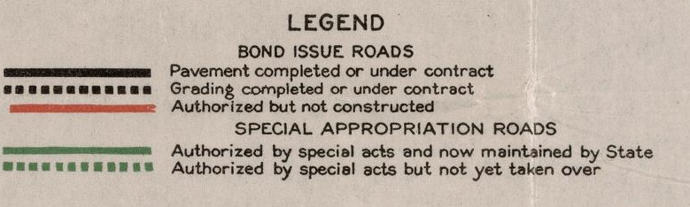
The Sign State Routes were announced in the August 1934 California Highways & Public Works. California State Route 9 is shown as a highway originating from Santa Cruz north to Milpitas via Redwood Park (Big Basin).

CA 9 appears on LRN 44 and LRN 42 through Big Basin Redwoods State Park on the 1935 Goshua Highway Map of California.

CA 9 on LRN 42 and LRN 44 appear in detail on the 1935 Division of Highways Map of Santa Cruz County.

CA 9 through Big Basin Redwoods State Park appears clearly on the 1937 Goshua Highway Map of California.
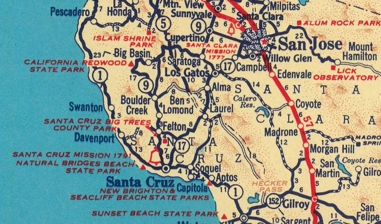
The first commercial map to show CA 9 on LRN 116 from Boulder Creek to Waterman Gap that I could find was the 1940 Rand McNally Map of California.
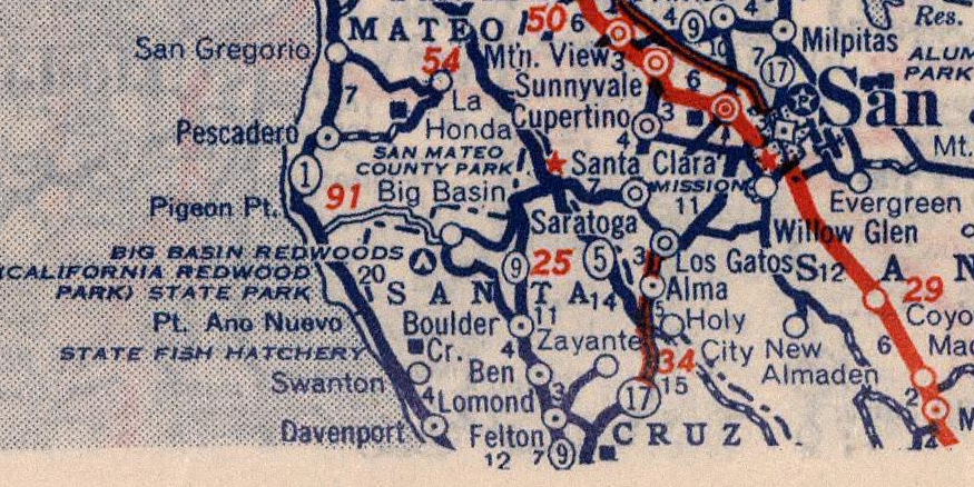
The first Division of Highways document that I could find which shows CA 9 on LRN 116 between Boulder Creek and Waterman Gap is the November/December 1951 California Highways & Public Works. CA 9 between Boulder Creek to Waterman Gap on LRN 116 appears on a list of approved projects for the 1952-53 fiscal year. It remains unclear why CA 9 was pushed off of Big Basin Highway but it can likely be assumed that it was intended to aid travel continuity across the Santa Cruz Mountains.

During the 1964 State Highway Renumbering LRN 42 and LRN 44 were consolidated into a new designation of CA 236. The 1964 Division of Highways State Map is the first display CA 236 through Big Basin Redwoods State Park.


Update 8/20/20; Big Basin Redwoods State Park was heavily damaged as the result of the CZU August Lightning Complex Fire. Initial news reports cite that potentially all the historic structures built by the Civilian Conservation Corps during the 1930s have been destroyed. It is currently unknown what the disposition of the Coastal Redwoods within the 18,000 acres of Big Basin Redwoods State Park presently is. As new reports come in from Big Basin Redwoods State Park this article will be updated.
Comments