Boca Road Bridge


The Boca Road Bridge is an abandoned wooden deck truss span located on the Truckee River near the former site of Boca siding.  The span was completed in 1926 prior to US Route 40 being built through the Truckee River Canyon.  Boca siding was plotted during the 1860s on the Dutch Flat & Donner Lake Road during the construction of the Central Pacific Railroad.  Boca siding was demolished in portions from the late 1920s through 1939 to make way for the site of Boca Dam.  


Part 1; the history of Boca siding and the Boca Road Bridge

Boca was founded in 1866 as Central Pacific Camp #17. The site was plotted as a railroad siding and renamed as Boca in 1868. The siding was home to a mill and icehouse which was connected to Truckee via Boca Road (now mostly under the Boca Reservoir).

Boca Road is a segment of what was the Dutch Flat & Donner Lake Wagon Road. Said corridor was developed as a frontage of the Central Pacific Railroad during construction of the line in the 1860s. Despite a roadway following the railroad through Truckee River Canyon overland traffic preferred the Dog Valley Grade east of Truckee. The Dog Valley Grade would be incorporated into the Lincoln Highway in 1913.

Boca can be seen on the Dutch Flat & Donner Lake Road on the 1882 Bancroft's map of California.


Boca can be seen in detail on the 1893 United States Geological Survey map of Truckee. A bridge over the Truckee River can be seen carrying Boca Road east of the siding site towards Hirschdale.


Nevada County contracted construction firm Rocca & Caletti to build of the Boca Road Bridge in 1925 (courtesy Dana Scanlon of the A Tahoe and Northern Nevada History Facebook group). The span was ultimately completed during 1926 and was not dissimilar to other truss designs with wooden road decks seen in the 1920s. The previous structure along Boca Road at the Truckee River can be seen below in a Wiki Media Image (year unknown).


The 1919 Third State Highway Bond Act added an addition to Legislative Route Number 38 (LRN 38) which defined a new segment of State Highway intended to replace the Dog Valley Grade and serve Boca:

"A certain highway Nevada and Sierra counties, running as follows: From a point in the town of Truckee where the present state highway branches at the subway under the Southern Pacific tracks going toward Lake Tahoe, continuing through the town of Truckee, crossing Prosser Creek and over what is known as the "Dog Valley Grade" as far as the state line about 1 mi NW of Verdi, Nevada..."

LRN 38 east of Truckee appears as a planned highway bypassing the Dog Valley Grade on the 1920 California Highway Commission Map


The Nothern Lincoln Highway can be seen using the Dog Valley Grade from Truckee east to Verdi on the 1920 Clason Roads of California and Nevada Map.  


The Victory Highway was formally organized during 1921 as a coast-to-coast highway aligned from New York to San Francisco.  The Victory Highway Association lived on after the creation of the US Route System and became the US Route 40 Association in 1938.  

The June 1924 California Highways & Public Works noted the initial grading LRN 38 between Truckee along the Truckee River to Boca was underway.  


The August 1924 California Highways & Public Works noted LRN 38 between Truckee-Boca was in the process being graded.  


The October 1924 California Highways & Public Works stated numerous contracts were underway on LRN 38 from Truckee east to the Nevada State Line. 


The June 1925 California Highways & Public Works noted surveys were underway to find the final location of LRN 38 within Truckee.  

The initial draft of the US Route System was approved by the Secretary of Agriculture during November of 1925.  The US Route System within California was approved by California Highway Commission with no changes recommended by January 1926.  The alignment of US Route 40 east of Sacramento was planned to follow the existing Northern Branch of the Lincoln Highway and Victory Highway over LRN 3, LRN 17, LRN 37 and LRN 38 to the Nevada state line at Verdi. 


Thusly US Route 40 appears on the 1925 Rand McNally Map of California east of Sacramento to Verdi.  Conceptual US Route 40 is shown following the Dog Valley Grade east of Truckee.

The May 1926 California Highways & Public Works noted LRN 38 in the Truckee River Canyon between Truckee and the Nevada state line as having been fully graded.  The new segment of LRN 38 is stated to have a planned opening on June 10, 1926, as a bypass to the Dog Valley Grade. 


The completion of LRN 38 east of Truckee to Verdi by way of the Truckee River Canyon was featured in the June 1926 California Highways & Public Works.  The 19.1 mile long "Truckee River Highway" was dedicated on June 10, 1926, by California Governor Friend Richardson.  


The US Route System was formally approved by the American Association of State Highway Officials (AASHO) on November 11, 1926.  The approval of the US Route System formally brought US Route 40 into existence east of Sacramento to the Nevada State Line.  Notably US Route 40 east of Sacramento to the Nevada State Line was referred to as the Victory Highway in numerous official documents into the 1930s.  US Route 40 from the outset of the US Route System was aligned through the Truckee River Canyon east of Truckee to Verdi.  

During the late 1920s the advent of modern refrigeration industry led to a decline in Boca.  Much of the siding facility and icehouse was demolished before the end of the decade.  The remaining structures were demolished in 1939 to make way for Boca Dam.  Construction would lead to Boca Road being realigned over the dam structure.  

US Route 40 can be seen running past Boca on the south side of the Truckee River on the 1940 United States Geological Survey map of Truckee.  The Boca Road Bridge is shown connecting directly to US Route 40.  


The current bridge carrying Hirschdale Road to Boca appears to have been constructed during the 1950s concurrent to Interstate 80 in the Truckee River Canyon.  The structure appears on the 1977 United States Geological Survey map of Truckee.  


Part 2; a visit to the Boca Road Bridge and Boca Siding

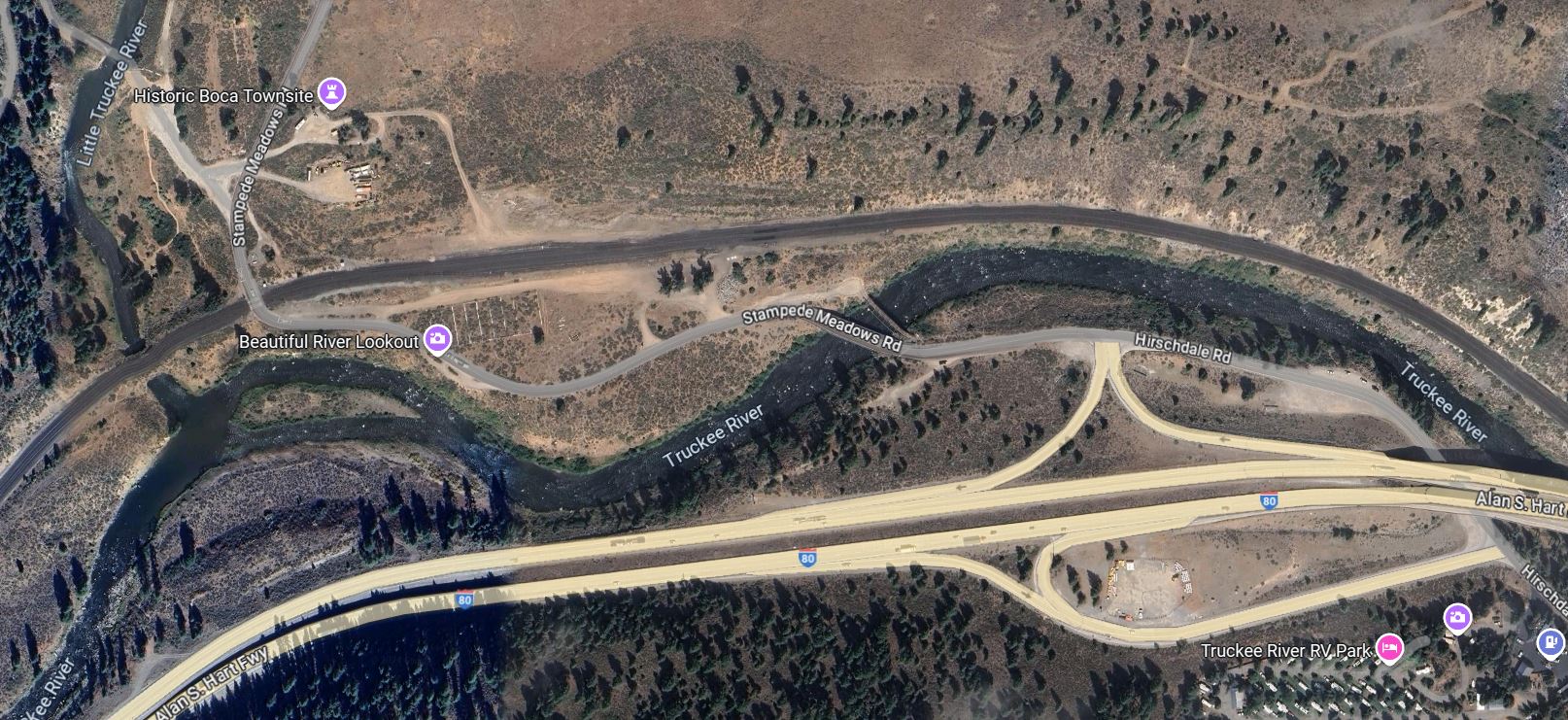
The Boca Road Bridge can be found north of Interstate 80 Exit 194. The structure is easy to find next to the Hirschdale Road Bridge.


The Boca Road Bridge can be accessed on foot and is still be crossed by pedestrian traffic. The cobblestone footings of the span reveal no date of construction.


The site of Boca siding is west of the Boca Road Bridge and easily identified by the numerous tall trees lining the railroad tracks.


Comments

Popular posts from this blog

Grand Loop Road of Yellowstone National Park

  Grand Loop Road is a 140 mile loop highway which traverses the interior of Yellowstone National Park.  Grand Loop Road connects all of the major attractions and geological features of Yellowstone National Park along with the entrance roads.  Grand Loop Road is a seasonal highway and despite some conjecture never has been part of the US Route System.   Part 1; the history of Grand Loop Road The majority of history pertaining to Grand Loop Road was taken from the below National Park Service article: Historic Roads - Yellowstone National Park (U.S. National Park Service) (nps.gov) Yellowstone was declared the first National Park of the United States on March 1st, 1872.  The first real highway to access Yellowstone National Park came in 1873 when a tolled facility was constructed from Bozeman, Montana via Yankee Jim Canyon to Mammoth Hot Springs.  Numerous attempts were made to fund construction of roadway infrastructure during the early years of Yellows...

The last 1956-63 era California Sign State Route Spade?

Along southbound California State Route 170 (the Hollywood Freeway Extension) approaching the Hollywood Freeway/Ventura Freeway interchange a white California State Route 134 Sign State Route Spade can be observed on guide sign.  These white spades were specifically used during the 1956-63 era and have become increasingly rare.  This blog is intended to serve as a brief history of the Sign State Route Spade.  We also ask you as the reader, is this last 1956-63 era Sign State Route Spade or do you know of others?  Part 1; the history of the California Sign State Route Spade Prior to the Sign State Route System, the US Route System and the Auto Trails were the only highways in California signed with reassurance markers.  The creation of the US Route System by the American Association of State Highway Officials during November 1926 brought a system of standardized reassurance shields to major highways in California.  Early efforts to create a Sign State Route ...

California State Route 70; the Feather River Highway

From 2017 through to early 2019 I drove the majority of the California State Route 70; the Feather River Highway from CA 89 southwest to CA 99. CA 70 is an approximately 178.5 mile state highway which starts at US 395 near the Nevada State Line and travels west through the Feather River Canyon to CA 99.  CA 70 is often referred to as the Feather River Highway" given it's close association with the river.  Historically CA 70 was previously signed as US 40A and CA 24.  The Legislative Routes prior to the 1964 California Highway Renumbering that made up the current route of CA 70 are as follows: -  Legislative Route Number 21 from US 395 westward to Oroville. -  LRN 87 from Oroville south to Marysville. -  LRN 232 from Marysville to the current junction with CA 99.  CA 70 was even dual signed with CA 99 into Sacramento on what was LRN 232 for a time. The change from US 40A/LRN 21/LRN 87/LRN 232 can be seen by comparing the 1963 State Highway Ma...