
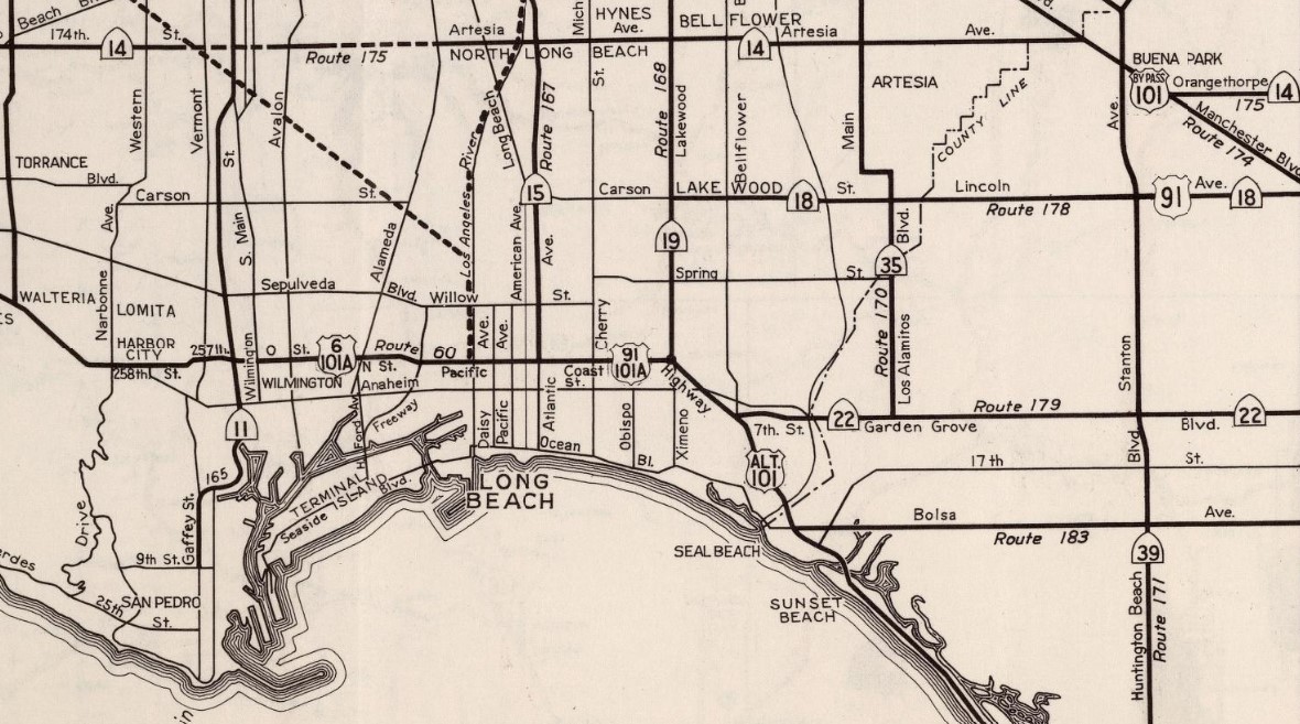
California State Route 214 was created during the 1964 State Highway Renumbering out what had been US Route 91 and California State Route 18 in Los Angeles County and Orange County. California State Route 214 was defined as following Carson Street and Lincoln Avenue from California State Route 19/Lakewood Boulevard east to Interstate 5/Santa Ana Freeway. California State Route 214 was deleted from the State Highway System during 1981.

The history of California State Route 214
What was to become California State Route 214 entered the State Highway System during 1933 as Legislative Route Number 178 (LRN 178). The original definition of LRN 178 was as follows:
"Cerritos Avenue (now Lakewood Avenue) to LRN near Olive via Anaheim"
LRN 178 appears for the first time on the 1934 Division of Highways Map following Carson Street, Lincoln Avenue and Center Street (now Lincoln Avenue in Anaheim) between LRN 168-LRN 43.


The August 1934 California Highways & Public Works announced the initial run of Sign State Routes. The entirety of LRN 178 was assigned as the southernmost leg of California State Route 18.


Almost the entirety of California State Route 18/LRN 178 appears in detail on the 1935 Division of Highways Map of Orange County. The terminus of California State Route 18/LRN 178 at California State Route 19/LRN 168 near Artesia of Los Angeles County along Carson Street can also be seen.

On July 1, 1947, the American Association of State Highway Officials (AASHO) Executive Secretary notified the California State Highway Engineer that California's request to extend US Route 91 from Barstow to Long Beach had been approved. The extension of US Route 91 to Long Beach brought it into the city via multiplex of California State Route 19/LRN 168 to Los Alamitos Traffic Circle and west on US Route 101A/LRN 60 on Pacific Coast Highway. US Route 91 also multiplexed the entirety of California State Route 18/LRN 178.


1953 Legislative Chapter 1836 truncated LRN 178 to the new mainline of US Route 101 at Manchester Avenue/LRN 174. This measure removed the entirety of LRN 178 between US Route 101/LRN 174 east through Anaheim to LRN 43. The new definition of LRN 178 appears on the 1954 Division of Highways Map. US Route 91 and California State Route 18 both appear to still be routed along Center Street in Anaheim and Olive.


US Route 91 and California State Route 18 appear to be rerouted from the eastern terminus of LRN 178 onto US Route 101/LRN 174 and California State Route 14/LRN 175 towards LRN 43 in Santa Ana Canyon on the 1956 Division of Highways Map. 1957 Legislative Chapter 36 clarified the end points of LRN 178 as "LRN 168 near Lakewood and LRN 174 near Anaheim."

California State Route 18 was truncated to San Bernardino during 1961 which left US Route 91 as the only Sign Route on LRN 178. US Route 91 appears solely on LRN 178 on the 1962 Division of Highways Map.

US Route 91 was requested by the Division of Highways to be truncated to Barstow during 1963. The truncation of US Route 91 to Barstow appears in a letter written by the State Highway Engineer to the AASHO Executive Secretary dated August 26, 1963.


As part of the 1964 State Highway Renumbering all the Legislative Route Numbers were dropped in favor of Sign Route designations. Subsequently the entirety of LRN 178 was redesignated as California State Roue 214. California State Route 214 appears for the first time on the 1964 Division of Highways Map.
1965 Legislative Chapter 1372 added a stipulation to the definition of California State Route 214:
"This route shall cease to be a state highway when Route 91 freeway is completed from Route 19 to Route 5 and the commission relinquishes that portion of present Route 91 from Route 19 to Route 5."
The stipulation set by 1965 Legislative Chapter 1372 was acted upon as part of 1981 Legislative Chapter 292 which deleted California State Route 214 from the State Highway System.
Comments